Mechanicsville, Schuylkill County, Pennsylvania
| Mechanicsville, Pennsylvania | |
|---|---|
| Borough | |
 Pottsville Street in Mechanicsville | |
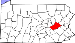
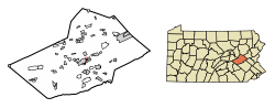 Location of Mechanicsville in Schuylkill County, Pennsylvania. | |
 Mechanicsville Location in Pennsylvania  Mechanicsville Mechanicsville (the US) | |
| Coordinates: 40°41′30″N 76°10′54″W / 40.69167°N 76.18167°WCoordinates: 40°41′30″N 76°10′54″W / 40.69167°N 76.18167°W | |
| Country | United States |
| State | Pennsylvania |
| County | Schuylkill |
| Incorporated | 1914 |
| Government | |
| • Type | Borough Council |
| Area[1] | |
| • Total | 0.33 sq mi (0.84 km2) |
| • Land | 0.33 sq mi (0.84 km2) |
| • Water | 0.00 sq mi (0.00 km2) |
| Population (2010) | |
| • Total | 457 |
| • Estimate (2016)[2] | 445 |
| • Density | 1,365.03/sq mi (527.41/km2) |
| Time zone | UTC-5 (Eastern (EST)) |
| • Summer (DST) | UTC-4 (EDT) |
| Area code(s) | 570 |
| FIPS code | 42-48448 |
| GNIS feature ID | 1215555 |
Mechanicsville is a borough in Schuylkill County, Pennsylvania, United States. The population was 515 at the 2000 census. The borough lies between Pottsville and Port Carbon. Pottsville Street is the main street of town. The borough of part of the Pottsville Area School District.
Geography
Mechanicsville is located at 40°41′30″N 76°10′54″W / 40.69167°N 76.18167°W (40.691596, -76.181576).[3]
According to the United States Census Bureau, the borough has a total area of 0.3 square miles (0.9 km²), all of it land.
Demographics
| Historical population | |||
|---|---|---|---|
| Census | Pop. | %± | |
| 1920 | 560 | — | |
| 1930 | 706 | 26.1% | |
| 1940 | 748 | 5.9% | |
| 1950 | 540 | −27.8% | |
| 1960 | 588 | 8.9% | |
| 1970 | 663 | 12.8% | |
| 1980 | 519 | −21.7% | |
| 1990 | 540 | 4.0% | |
| 2000 | 515 | −4.6% | |
| 2010 | 457 | −11.3% | |
| Est. 2016 | 445 | [2] | −2.6% |
| Sources:[4][5][6] | |||
As of the census[5] of 2000, there were 515 people, 209 households, and 149 families residing in the borough. The population density was 1,559.8 people per square mile (602.6/km²). There were 230 housing units at an average density of 696.6/sq mi (269.1/km²). The racial makeup of the borough was 98.25% White, 0.19% African American, 0.19% Asian, and 1.36% from two or more races. Hispanic or Latino of any race were 0.78% of the population.
There were 209 households out of which 28.7% had children under the age of 18 living with them, 57.4% were married couples living together, 9.1% had a female householder with no husband present, and 28.7% were non-families. 23.9% of all households were made up of individuals and 13.9% had someone living alone who was 65 years of age or older. The average household size was 2.46 and the average family size was 2.93.
In the borough the population was spread out with 22.5% under the age of 18, 6.0% from 18 to 24, 25.6% from 25 to 44, 25.4% from 45 to 64, and 20.4% who were 65 years of age or older. The median age was 42 years. For every 100 females there were 87.3 males. For every 100 females age 18 and over, there were 90.0 males.
The median income for a household in the borough was $34,583, and the median income for a family was $40,556. Males had a median income of $33,750 versus $21,354 for females. The per capita income for the borough was $16,511. About 8.0% of families and 12.1% of the population were below the poverty line, including 18.7% of those under age 18 and 16.7% of those age 65 or over.
References
- ↑ "2016 U.S. Gazetteer Files". United States Census Bureau. Retrieved Jul 4, 2017.
- 1 2 "Population and Housing Unit Estimates". Retrieved June 9, 2017.
- ↑ "US Gazetteer files: 2010, 2000, and 1990". United States Census Bureau. 2011-02-12. Retrieved 2011-04-23.
- ↑ "Census of Population and Housing". U.S. Census Bureau. Retrieved 11 December 2013.
- 1 2 "American FactFinder". United States Census Bureau. Retrieved 2008-01-31.
- ↑ "Incorporated Places and Minor Civil Divisions Datasets: Subcounty Resident Population Estimates: April 1, 2010 to July 1, 2012". Population Estimates. U.S. Census Bureau. Archived from the original on 17 June 2013. Retrieved 11 December 2013.
| Wikimedia Commons has media related to Mechanicsville, Schuylkill County, Pennsylvania. |