Ringtown, Pennsylvania
| Ringtown, Pennsylvania | |
|---|---|
| Borough | |
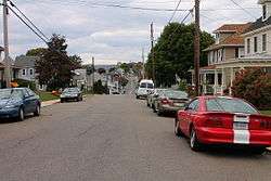 Main Street in Ringtown, looking west | |
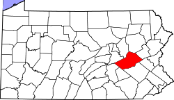
 Location of Ringtown in Schuylkill County, Pennsylvania. | |
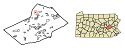
 Ringtown Location in Pennsylvania  Ringtown Ringtown (the US) | |
| Coordinates: 40°51′27″N 76°14′01″W / 40.85750°N 76.23361°WCoordinates: 40°51′27″N 76°14′01″W / 40.85750°N 76.23361°W | |
| Country | United States |
| State | Pennsylvania |
| County | Schuylkill |
| Settled | 1833 |
| Incorporated | 1909 |
| Government | |
| • Type | Borough Council |
| • Mayor | Albert Breznik |
| Area[1] | |
| • Total | 0.44 sq mi (1.14 km2) |
| • Land | 0.44 sq mi (1.14 km2) |
| • Water | 0.00 sq mi (0.00 km2) |
| Population (2010) | |
| • Total | 818 |
| • Estimate (2016)[2] | 791 |
| • Density | 1,801.82/sq mi (695.42/km2) |
| Time zone | UTC-5 (Eastern (EST)) |
| • Summer (DST) | UTC-4 (EDT) |
| ZIP code | 17967 |
| Area code(s) | 570 Exchange: 889 |
| FIPS code | 42-65000 |
Ringtown is a borough in Schuylkill County, Pennsylvania, United States. It is approximately 5 miles north northwest of Shenandoah and 17 miles west southwest of Hazleton. Other nearby towns and boroughs include Zion Grove, Pattersonville, and Nuremberg.
Geography
Ringtown is located at 40°51′27″N 76°14′1″W / 40.85750°N 76.23361°W (40.857604, −76.233718).[3]
According to the United States Census Bureau, the borough has a total area of 0.4 square miles (1.0 km2), which is all land.
Demographics
| Historical population | |||
|---|---|---|---|
| Census | Pop. | %± | |
| 1910 | 723 | — | |
| 1920 | 785 | 8.6% | |
| 1930 | 899 | 14.5% | |
| 1940 | 910 | 1.2% | |
| 1950 | 835 | −8.2% | |
| 1960 | 849 | 1.7% | |
| 1970 | 880 | 3.7% | |
| 1980 | 837 | −4.9% | |
| 1990 | 853 | 1.9% | |
| 2000 | 826 | −3.2% | |
| 2010 | 818 | −1.0% | |
| Est. 2016 | 791 | [2] | −3.3% |
| Sources:[4][5][6] | |||
As of the census[5] of 2000, there were 826 people, 319 households, and 231 families residing in the borough. The population density was 1,869.1 people per square mile (724.8/km²). There were 340 housing units at an average density of 769.4 per square mile (298.4/km²). The racial makeup of the borough was 98.79% White, 0.12% African American, 0.48% Asian, 0.61% from other races. Hispanic or Latino of any race were 0.61% of the population.
There were 319 households out of which 30.4% had children under the age of 18 living with them, 59.2% were married couples living together, 8.8% had a female householder with no husband present, and 27.3% were non-families. Of all households, 23.2% were made up of individuals and 12.9% had someone living alone who was 65 years of age or older. The average household size was 2.59 and the average family size was 3.09.
In the borough the population was spread out with 24.7% under the age of 18, 6.4% from 18 to 24, 25.7% from 25 to 44, 22.5% from 45 to 64, and 20.7% who were 65 years of age or older. The median age was 39 years. For every 100 females there were 89.4 males. For every 100 females age 18 and over, there were 92.6 males.
The median income for a household in the borough was $36,563, and the median income for a family was $43,125. Males had a median income of $32,685 versus $22,000 for females. The per capita income for the borough was $20,345. About 2.6% of families and 4.6% of the population were below the poverty line, including 4.4% of those under age 18 and 11.2% of those age 65 or over.
Notable people
- Danny Litwhiler, baseball player and coach
References
- ↑ "2016 U.S. Gazetteer Files". United States Census Bureau. Retrieved Aug 14, 2017.
- 1 2 "Population and Housing Unit Estimates". Retrieved June 9, 2017.
- ↑ "US Gazetteer files: 2010, 2000, and 1990". United States Census Bureau. 2011-02-12. Retrieved 2011-04-23.
- ↑ "Census of Population and Housing". U.S. Census Bureau. Retrieved 11 December 2013.
- 1 2 "American FactFinder". United States Census Bureau. Retrieved 2008-01-31.
- ↑ "Incorporated Places and Minor Civil Divisions Datasets: Subcounty Resident Population Estimates: April 1, 2010 to July 1, 2012". Population Estimates. U.S. Census Bureau. Archived from the original on 17 June 2013. Retrieved 11 December 2013.