Travisville, Indiana
| Travisville, Indiana | |
|---|---|
| Unincorporated community | |
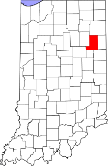 Wells County's location in Indiana | |
 Travisville Location of Travisville in Wells County | |
| Coordinates: 40°41′31″N 85°12′28″W / 40.69194°N 85.20778°WCoordinates: 40°41′31″N 85°12′28″W / 40.69194°N 85.20778°W | |
| Country | United States |
| State | Indiana |
| County | Wells |
| Township | Harrison |
| Elevation[1] | 843 ft (257 m) |
| Time zone | UTC-5 (Eastern (EST)) |
| • Summer (DST) | UTC-4 (EDT) |
| ZIP code | 46714 |
| Area code(s) | 260 |
| GNIS feature ID | 444860 |
Travisville is an unincorporated community in Harrison Township, Wells County, in the U.S. state of Indiana.[2]
History
Travisville was named after John Travis, who laid out the community.[3]
A post office called Travis was established in 1873, and remained in operation until it was discontinued in 1877.[4]
Geography
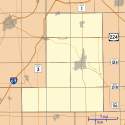
Travisville is located at 40°41′31″N 85°12′28″W / 40.69194°N 85.20778°W.
References
- ↑ "US Board on Geographic Names". United States Geological Survey. October 25, 2007. Retrieved 2016-06-17.
- ↑ "Travisville, Indiana". Geographic Names Information System. United States Geological Survey. Retrieved July 24, 2017.
- ↑ "Profile for Travisville, IN". ePodunk. Retrieved July 7, 2016.
- ↑ "Wells County". Jim Forte Postal History. Retrieved July 7, 2016.
Municipalities and communities of Wells County, Indiana, United States | ||
|---|---|---|
| City | ||
| Towns | ||
| Townships | ||
| Unincorporated communities | ||
| Footnotes | ‡This populated place also has portions in an adjacent county or counties | |
This article is issued from
Wikipedia.
The text is licensed under Creative Commons - Attribution - Sharealike.
Additional terms may apply for the media files.