Rockcreek Township, Wells County, Indiana
| Rockcreek Township | |
|---|---|
| Township | |
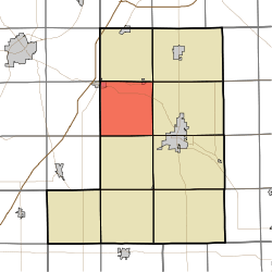 Location in Wells County | |
| Coordinates: 40°46′48″N 85°16′43″W / 40.78000°N 85.27861°WCoordinates: 40°46′48″N 85°16′43″W / 40.78000°N 85.27861°W | |
| Country | United States |
| State | Indiana |
| County | Wells |
| Government | |
| • Type | Indiana township |
| Area | |
| • Total | 35.91 sq mi (93.0 km2) |
| • Land | 35.57 sq mi (92.1 km2) |
| • Water | 0.34 sq mi (0.9 km2) 0.95% |
| Elevation[1] | 820 ft (250 m) |
| Population (2010) | |
| • Total | 1,579 |
| • Density | 44.4/sq mi (17.1/km2) |
| Time zone | UTC-5 (Eastern (EST)) |
| • Summer (DST) | UTC-4 (EDT) |
| ZIP codes | 46714, 46750, 46770, 46791 |
| Area code(s) | 260 |
| GNIS feature ID | 453811 |
Rockcreek Township is one of nine townships in Wells County, Indiana, United States. As of the 2010 census, its population was 1,579 and it contained 645 housing units.[2]
Geography
According to the 2010 census, the township has a total area of 35.91 square miles (93.0 km2), of which 35.57 square miles (92.1 km2) (or 99.05%) is land and 0.34 square miles (0.88 km2) (or 0.95%) is water.[2]
Cities, towns, villages
Unincorporated towns
(This list is based on USGS data and may include former settlements.)
Adjacent townships
- Union Township (north)
- Jefferson Township (northeast)
- Lancaster Township (east)
- Harrison Township (southeast)
- Liberty Township (south)
- Salamonie Township, Huntington County (southwest)
- Rock Creek Township, Huntington County (west)
- Union Township, Huntington County (northwest)
Cemeteries
The township contains these three cemeteries: Horeb, Sparks and Spider Hill.
Rivers
School districts
- Northern Wells Community Schools
Political districts
- Indiana's 6th congressional district
- State House District 82
- State Senate District 19
References
- United States Census Bureau 2007 TIGER/Line Shapefiles
- United States Board on Geographic Names (GNIS)
- IndianaMap
- History of Rockcreek High School, Rockcreek Township
- ↑ "US Board on Geographic Names". United States Geological Survey. October 25, 2007. Retrieved 2017-05-09.
- 1 2 "Population, Housing Units, Area, and Density: 2010 - County -- County Subdivision and Place -- 2010 Census Summary File 1". United States Census. Retrieved 2013-05-10.
External links
Municipalities and communities of Wells County, Indiana, United States | ||
|---|---|---|
| City | ||
| Towns | ||
| Townships | ||
| Unincorporated communities | ||
| Footnotes | ‡This populated place also has portions in an adjacent county or counties | |
This article is issued from
Wikipedia.
The text is licensed under Creative Commons - Attribution - Sharealike.
Additional terms may apply for the media files.