Transport in Mozambique
Modes of transport in Mozambique include rail, road, water, and air. There are rail links serving principal cities and connecting the country with Malawi, Zimbabwe and South Africa. There are over 30,000km of roads, but much of the network is unpaved.
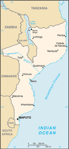
On the Indian Ocean coast are several large seaports, including Nacala, Beira and Maputo, with further ports being developed. There are 3,750km of navigable inland waterways. There is an international airport at Maputo, 21 other paved airports, and over 100 with unpaved runways.
Railways
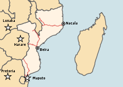
The Mozambican railway system developed over more than a century from three different ports on the Indian Ocean that serve as terminals for separate lines to the hinterland. The railroads were major targets during the Mozambican Civil War, were sabotaged by RENAMO, and are being rehabilitated. A parastatal authority, Portos e Caminhos de Ferro de Moçambique (abbreviated CFM; in English Mozambique Ports and Railways), oversees the railway system of Mozambique and its connected ports, but management has been largely outsourced. Each line has its own development corridor.
As of 2005 there are 3,123 km of railway track, consisting of 2,983 km of 1,067 mm (3 ft 6 in) gauge, compatible with neighboring rail systems, and a 140 km line of 762 mm (2 ft 6 in) gauge, the Gaza Railway.[1] The central Beira Railroad Corporation route links the port of Beira to the landlocked countries of Malawi, Zambia and Zimbabwe. To the north of this the port of Nacala is also linked by rail to Malawi via the Northern Development Corridor, and to the south Maputo is linked to Zimbabwe and South Africa. These networks interconnect only via neighbouring countries. A new route for coal haulage between Tete and Beira was planned to come into service by 2010,[2] and in August 2010, Mozambique and Botswana signed a memorandum of understanding to develop a 1,100 km railway through Zimbabwe, to carry coal from Serule in Botswana to a deepwater port at Techobanine Point in Mozambique.[3]
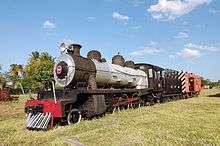
Newer rolling stock has been supplied by the Indian Golden Rock workshop[4] using Centre Buffer Couplers (AAR)[5] and air brakes.
Towns served by railways
Highways
As of 1996 there was estimated to be a total of 30,400 km of highways, of which 5,685 km was paved.
Waterways
There are 3,750 km of navigable waterways.
Sea transport
Ports and harbours
Seaports on the Indian Ocean coast include:
Merchant marine
As of 2002 the merchant marine fleet consists of three cargo ships of 1,000 GRT or over, totaling 4,125 RT/7,024 tonnes deadweight (DWT). Two of these are Belgian-owned ships registered in Mozambique as a flag of convenience.
Airports
As of 2006 there were 158 airports in total, 22 of them having paved runways. The main airport in the country is Maputo International Airport, which is also the hub of Mozambique's flag carrier, LAM Mozambique Airlines.
References
| Wikimedia Commons has media related to Transport in Mozambique. |
- ↑ CIA factbook
- ↑ "Mozambique: Australian Company Plans New Coal Mine in Tete By 2010". Allafrica.com. Retrieved 24 December 2014.
- ↑ "Railway Gazette: Pointers September 2010". Retrieved 2010-09-10.
- ↑ Railway Gazette International, August 2008, p.483
- ↑ "Golden Rock workshop exports locos to Mozambique". The Hindu Business Line. Archived from the original on 6 December 2010. Retrieved 24 December 2014.
- ↑ "New Mozambique port gets approval". Railways Africa. Retrieved 24 December 2014.
External links
Rail network maps
Currency: Metical | |
| Communications |
|
| Industries: | |
![]()