Transport in Nigeria

Decaying infrastructure is one of the deficiencies that Nigeria's National Economic Empowerment Development Strategy (NEEDS) seeks to address. The government has begun to repair the country's poorly maintained road network. Because Nigeria's railways are in a perilous condition, the government is trying to rectify the situation by privatizing the Nigerian Railway Corporation. Similarly, the government is pursuing a strategy of partial port privatization by granting concessions to private port operators so that they can improve the quality of port facilities and operations.
Railways
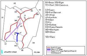
Railways in Nigeria are operated by the Nigerian Railway Corporation. Nigeria's railway system has 3,984 kilometers of track, most of which is Cape gauge. The country has two major rail lines: a western line that connects Lagos to Nguru, and an eastern line that connects Port Harcourt to Maiduguri. The Lagos–Kano Standard Gauge Railway is being built in segments to replace the western Cape gauge line. Several metro systems are under construction.
Highways
Nigeria has the largest road network in West Africa and the second largest south of the Sahara, with roughly 108,000 km of surfaced roads in 1990.
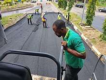
However they are poorly maintained and are often cited as a cause for the country's high rate of road fatalities. In 2004 Nigeria's Federal Roads Maintenance Agency (FERMA) began to patch the 32,000 kilometre federal roads network, and in 2005 FERMA initiated a more substantial rehabilitation. The rainy season and poor equipment pose challenges to road maintenance.[1]
These are the portions that are already modernized at motorway and expressway standard:
| Motorway Number | Route | Built | Planned | Remarks |
|---|---|---|---|---|
| A1 | Agapa Rd - E1 | 15 km | ||
| A1 | Oyo – Ogbomosho | 35 km | u/c, end of 2015 | |
| A2 | Warri – Benin City | 77 km | Benin City Bypass | |
| A2 | Madalla/Abuja (A234) – Kaduna (A235) | 179 | ||
| A2 | Kaduna North – Kano | 221 | Ring Road/Eastern Bypass | |
| A3 | Port Harcourt (E-W Rd) – Umuahia (Umu Opara Rd. /Mission Hill) | 100 | ||
| A3 | Okigwe – Enugu (A343) | 87 | ||
| A3 | Enugu – Ngwo (A232) | 13 | ||
| A5 | Papalanto – Abeokuta | 37 | ||
| A121 | Logbara/Sagamu(E1) - Benin City (A121, Benin City Bypass) | 247 | Shagamu- Benin Expy | |
| A122 | Ibadan – Ife | 63 | Ibadan – Ife Expy | |
| A232 | Benin City (Benin City Bypass) – Agbor (Aliagu Rd.) | 46 | ||
| A232 | Agbor (Lagos -Asaba Rd.) – Enugu (A3) | 161 | ||
| A234 | Abuja North Bypass (Gado Nasko Rd. – Murtalla Mohammed Expy) | 25 | ||
| E1 | Ring Rd Apongbon St – A1 | 21.5 | Lagos East Bypass | |
| - | Apapa – Oworonshoki- Tin Can Access - Creek Road | 28.5 | Apapa – Oworonshoki Expy/ West and South Lagos Bypass | |
| - | Ring Rd Apongbon St – A1 | 80 | Lagos - Badagry Expy | |
| - | Ijora Cause Way | 2 | Lagos South Bypass | |
| - | Eko Bridge - Apongbon St | 4 | Eko Bridge | |
| - | Murtala Mohammed Expy | 5 | Abuja East Bypass | |
| - | Nnamdi Azikiwe Expy | 14 | Abuja West Bypass | |
| - | Airport Rd. /Umaru Musa Yar’Adua Rd. | 38 | Abuja South Bypass | |
Figures from CIA World Factbook (1999):
Total:
194,394 km
paved:
60,068 km (including 1,194 km of expressways)
unpaved:
134,326 km (1998 est.)
note:
Some paved roads have lost their asphalt surface and are in very poor condition or have reverted to being gravel roads. Some of the road system is barely usable, especially in high rainfall areas of the south.
International highways
Nigeria's strategic location and size results in four routes of the Trans-African Highway network using its national road system:
- The Trans-Sahara Highway to Algeria is almost complete but border security issues may hamper its use in the short term.
- The Trans-Sahelian Highway to Dakar is substantially complete.
- The Trans–West African Coastal Highway starts in Nigeria, connecting it westwards to Benin, Togo, Ghana and Ivory Coast with feeder highways to landlocked Burkina Faso and Mali. When construction in Liberia and Sierra Leone is finished, the highway will continue seven other Economic Community of West African States (ECOWAS) nations further west.
- The Lagos-Mombasa Highway has been awaited for many decades to kick-start trade across the continent. It does provide improved highway links to neighbouring Cameroon, but its continuation across DR Congo to East Africa is lacking, as are highways from Cameroon to Central Africa and Southern Africa, which could boost trade within the continent.
Waterways
Nigeria has 8,600 km of inland waterways. The longest are the Niger River and its tributary, the Benue River[1] but the most used, especially by larger powered boats and for commerce, are in the Niger Delta and all along the coast from Lagos Lagoon to Cross River.
Pipelines
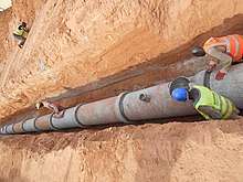
In 2004 Nigeria had 105 kilometers of pipelines for condensates, 1,896 kilometers for natural gas, 3,638 kilometers for oil, and 3,626 kilometers for refined products. Various pipeline projects are planned to expand the domestic distribution of natural gas and to export natural gas to Benin, Ghana, Togo through the West African Gas Pipeline, and, potentially, even to Algeria (where Mediterranean export terminals are located) by proposed Trans-Saharan gas pipeline. Energy pipelines are subject to sabotage by militant groups or siphoning by thieves.[1]
crude oil 2,042 km; petroleum products 3,000 km; natural gas 500 km
Ports and harbors
The Nigerian Ports Authority (NPA) is responsible for managing Nigeria's ports, some of which have fallen behind international standards in terms of the quality of facilities and operational efficiency. Recognizing that the government lacks the funding and expertise to modernize facilities and run the ports efficiently, the NPA is pursuing partial port privatization by means of granting concessions to private port operators. Under the terms of concession agreements, the government would transfer operating rights to private companies for a finite number of years without forgoing ownership of the port land. Nigeria's principal container port is the port of Lagos, which handles about 5.75 million tons of cargo each year. The port, which consists of separate facilities at Apapa and Tin Can Island, has a rail connection to points inland. Port Harcourt, a transshipment port located 66 kilometers from the Gulf of Guinea along the Bonny River in the Niger Delta, handles about 815,000 tons of cargo each year and also has a railway connection. Both ports are not only responsible for Nigeria's seaborne trade but also serve inland countries such as Niger and Chad. A new port is under construction at Onne about 25 kilometers south of Port Harcourt. Relatively modern and efficient terminals managed by multinational oil companies handle most oil and gas exports.[1]
Atlantic Ocean
Merchant marine
The Nigerian Merchant Navy is not a legally recognized body, but the senior officers are represented by the Merchant Navy Officers' and Water Transport Senior Staff Association.[2][3] The maritime industry is regulated by the Nigerian Maritime Administration and Safety Agency (NIMASA), which is responsible for regulations related to Nigerian shipping, maritime labor and coastal waters. The agency also undertakes inspections and provides search and rescue services.[4]
total:
40 ships (1,000 gross register tons (GRT) or over) totaling 360,505 GRT/644,471 tonnes deadweight (DWT)
ships by type:
bulk carrier 1, cargo ship 12, chemical tanker 4, petroleum tanker 22, specialized tanker 1 (1999 est.)
Airport and airlines
Nigeria's principal airports are Murtala Muhammed International Airport in Lagos and Nnamdi Azikiwe International Airport in Abuja. Three other international airports are Mallam Aminu Kano International Airport in Kano, Akanu Ibiam International Airport in Enugu and Port Harcourt International Airport in Port Harcourt. Overall, Nigeria's airports, whether international or regional, suffer from a poor reputation for operational efficiency and safety. Private domestic air carriers began to win business at the expense of Nigeria Airways, the former government-owned national airline which was declared bankrupt in 2004. The former national flag carrier, Air Nigeria, suspended operations in 2012.[5] Arik Air is now a large airline serving Nigeria and has transported over 10 million passengers.[6]
Airports - with paved runways
total:
38
over 3,047 m:
9
2,438 to 3,047 m:
11
1,524 to 2,437 m:
10
914 to 1,523 m:
5
under 914 m:
3 (2010 est.)
Airports - with unpaved runways
total:
16
over 3,047 m:
1
1,524 to 2,437 m:
2
914 to 1,523 m:
11
under 914 m:
2 (2010 est.)
Heliports
1 (1999 est.) 2 (2006) There are at least 15 heliports to date including those in the oil sector
References
- 1 2 3 4 Library of Congress Country Studies, Nigeria.
- ↑ PHILIP NWOSU (December 21, 2007). "Fake Commodore arrested over military outfit". Online Nigeria. Retrieved 2011-06-23.
- ↑ Andrew Airahuobhor (5 August 2010). "Police Can't Ban Merchant Navy - Kemewerigha". The Daily Independent (Lagos). Retrieved 2011-06-23.
- ↑ "About NIMASA". NIMASA. Retrieved 2011-06-20.
- ↑ "Archived copy". Archived from the original on 2013-12-15. Retrieved 2014-07-28.
- ↑ http://www.arikair.com/our-history
General references

![]()