Transport in Waterford
This article deals with transport in Waterford city in Ireland. The city is connected by road, rail, bus, air and sea. There are currently proposals for a bus rapid transit (BRT) system, consisting of bus trams, or streetcars, to be used in future.
Rail
| Regional Rail Services from Waterford | |
|---|---|
Rail services in Waterford are provided by Iarnród Éireann, Ireland's national railway system. Rail services run from Plunkett Station Waterford. The station is located across Rice Bridge on the North side of the city. Services are provided to Dublin, Limerick, Rosslare Europort, Kilkenny, Clonmel. Freight services are also provided to Dublin, Port of Waterford and Rosslare Europort
There are seven daily services to Dublin including an express service which departs at 07:10 and takes 1 hour 50 minutes. Other services take around 2 Hours 10 Minutes. On Sundays there are four services.
There are two daily services to Limerick Junction via Clonmel. All services connect with Limerick, Cork (city), Ennis and Galway.
There used to be one daily service to Rosslare Europort. The service connected with Stena Line and Irish Ferries sailings to Fishguard and Pembroke Dock in the UK respectively. This rail service ceased after the operation of the evening train on Saturday 18 September 2010.[1] It was replaced by a revised Bus Éireann Route 370 service from 20 September 2010. However this bus service does not serve Waterford Railway Station.[2] In November 2016 it was revealed that Waterford could lose its connection to Limerick Junction by 2018 with the closure of the Limerick Junction Waterford line by CIE/IE to save money as the line has low demand.[3]
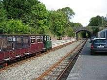
The award winning 3 ft (914 mm) narrow gauge Waterford & Suir Valley Railway[4] follows 10 km of the old Waterford to Dungarvan - Cork route along what is now part of the Deise Greenway. It is a heritage line that runs between Bilberry outside Waterford and Kilmeaden. The panoramic views from this line are considered to be exceptional and are enjoyed by over 28,000 passengers each year. The railway is a registered charity operated by over 50 volunteers who hope to return steam to the scenic route and extend the line closer into Waterford city in the near future.
Coach
Eurolines Coach route 890 operates from the tourist office.
| Number | Locations Served | |
|---|---|---|
| 890 | Pembroke Dock, Kilgetty, Carmarthen, Pont Abraham, Cardiff, Bristol, Reading and London Victoria Coach Station |
Bus
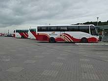
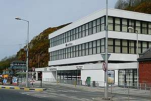
Bus Éireann and JJ Kavanagh and Sons provide bus services around Waterford city centre and to other towns and cities in Ireland. All regional bus services depart from the Waterford Bus Station on the quay and city centre services run throughout the city.
Planning for Bus lanes in the city centre are at an early stage and bus lanes will be on Parnell Street, Manor Street, The Mall, and the South Quays. A bus lane will be in each direction. On street parking will be removed from Parnell Street to facilitate the lanes. This is part of the city centre green plan.[5]
Bus Éireann City services
| Number | Route |
|---|---|
| 601 | Clock Tower - WIT - Ballybeg |
| 602 | Ballybricken - Clock Tower - Ballytruckle - Saint John's Park - Avondale - Kilcohan Park |
| 603 | Clock Tower - Lisduggan - Brown's Road - WIT
(and serves Ballybeg after 18:00) |
| 604 | Clock Tower - Hypercentre - Congress Place - Dominick Place - Gracedieu Road - Carrickpherish Road |
| 605 | University Hospital Waterford - Clock Tower - Hillview |
J. J. Kavanagh & Sons Waterford City Service
| Number | Route |
|---|---|
| 607 | Tesco Ardkeen - Williamston Road - Ballygunner - Dunmore Road - Clock Tower - Ferrybank - Abbey Park |
| 617 | Ballygunner - Dunmore Road - Clock Tower - Ferrybank - Slieverue
(and serves Tesco Ardkeen, Williamstown Road, and Abbey Park after 19:00) |
| 627 | Ballygunner - Dunmore Road - Clock Tower - Rockshire Road - Newrath |
Bus Éireann Regional services
| Number | Route |
|---|---|
| 4/X4 | New Ross - Waterford - Carlow - Dublin - Dublin Airport |
| 40 | Waterford - New Ross - Wexford - Rosslare Europort - (east) |
| 40 | Waterford - Dungarvan - Youghal - Cork - Killarney - Tralee (west) |
| 55 | Waterford - Clonmel - Limerick - Shannon Airport |
| 73 | Waterford - Athlone - Longford |
| 360/A | Waterford - Tramore |
| 362 | Waterford - Kilmacthomas - Dungarvan |
| 365 | Waterford - Thomastown |
| 366 | Waterford - Cappoquin - Lismore |
| 367 | Waterford - Carrick-on-Suir, Clonmel |
| 370 | Waterford - New Ross − Campile - Duncannon − Wellingtonbridge - Wexford - Rosslare Strand - Rosslare Europort |
| 371 | Waterford - New Ross - Adamstown |
J. J. Kavanagh & Sons
| Number | Route |
|---|---|
| 736 | Waterford - Carlow - Dublin - Dublin Airport |
| --- | (WIT) - Thurles - Roscrea - Cashel - Clonmel - Nenagh |
Dublin Coach
| Number | Route |
|---|---|
| 600 | Cork - Dungarvan - Waterford Institute of Technology - Waterford - Kilkenny - Dublin |
Suir Way Regional services
| Number | Route |
|---|---|
| 611 | Waterford - Dunmore East |
| 608 | Waterford - Passage East |
| 609 | Waterford - Portlaw |
Roads
.jpg)
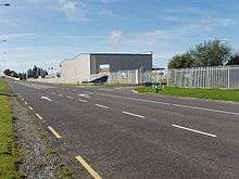
Over the last number of years the road network in Waterford have improved greatly. The city is connected to Cork, Dublin, Kilkenny, Dungarvan, Limerick, Wexford, Rosslare Europort and Clonmel and Tramore.
On 19 October 2009 the N25 Waterford City Bypass opened. The route consists of 23 km of High Quality Dual Carriageway as well as 14 km of Single carriageway and a second crossing over the River Suir. The road was designed as a Toll Road.[6][7]

On 22 March 2010 a section of the M9 opened as part of the new Motorway linking Waterford with Dublin. The final section between Carlow and Knocktopher was opened on September 9, 2010, which completed construction of the 118.5 km route.[8] Journey times have been cut between Kilkenny, Carlow and Dublin.[9]
In 2007 the R710 outer ring road opened. The road is a dual-carriageway which connects Ardkeen with the Waterford City Bypass which connects to all major primary routes from Waterford. The main airport road is also connected. The R709 forms the Inner Ring Road around the south of the inner city. The airport is located on the R708 road which can be accessed from the R710 outer ring road.
| Road | Route | E-Route |
|---|---|---|
 | Kilkenny - Carlow - Dublin | --- |
| Clonmel - Tipperary - Limerick | --- | |
| New Ross - Wexford - Rosslare Europort (east) | E-30 | |
| Dungarvan - Youghal - Cork (west) | E-30 | |
| Waterford City - Port of Waterford | --- |
Cycling
Waterford City Council are in the early stages of planning to have Cycle tracks in the city centre as part of the city centre green plan. There are other cycle tracks in the city but they are not in the main city centre. The new cycle lanes will be on Parnell Street, Manor Street, The Mall, and the South Quays. There will be a lane in each direction.
In July 2010 Waterford City Council have started to put cycle lanes around the city. Currently there is a cycle lane in both directions on the Cork road. They start from Ballybeg and contuine into the city centre. There are also lanes being put on the quays.
The Waterford Greenway is Ireland's longest greenway, and connects the city with Mount Congreve, Kilmeaden, Kilmacthomas, and Dungarvan.[10]
Waterford Port
Port of Waterford is located in Belview on the N29 on the north bank of the River Suir. The Port is the closest to mainland Europe from Ireland. Waterford Port is one of the busiest ports in Ireland.
The port is very important for tourism in Waterford. Between April and September 2010 25 Cruise Ships will dock in Dunmore East, Waterford Port and the quay in Waterford City Centre.[11] In September 2008 a new 190-metre quay was built that cost €11 million.
In 2008 the port of Waterford handled 2.5 million tons of cargo passed through the port.
The port hosted the Tall Ships race in 2005 and will do so again in June 2011.
The closest passenger port is Rosslare Europort in County Wexford [12] (72 km (45 miles) away by road), which has services to Fishguard, Pembroke Dock, Cherbourg, Roscoff and Le Havre.
Air
Waterford Airport is located 9 km south-east of Waterford. The airport serves Waterford and the south east region. There is currently no carrier operating flights at this airport. Aer Southeast is a new carrier established at Waterford Airport in 2017 and will operate flights to London Luton, Birmingham, and Manchester when they obtain a licence to operate these services.
There is an air sea rescue service operating out of Waterford Airport from a dedicated Irish Coastguard base.[13] This operation is currently contracted to a private operator, CHC Ireland. Rescue cover is provided by a Sikorsky S-61. A reserve S-61 helicopter is also based here.
See also
References
- ↑ http://www.irishrail.ie/news_centre/general_news.asp?action=view&news_id=900
- ↑ "Archived copy" (PDF). Archived from the original (PDF) on 2011-12-20. Retrieved 2012-01-21.
- ↑ https://www.nationaltransport.ie/wp-content/uploads/2016/11/151116_2016_Rail_Review_Report_Complete_Online.pdf
- ↑ The Waterford & Suir Valley Railway Official Homepage
- ↑ http://www.waterford-today.ie/index.php?option=com_content&task=view&id=4245&Itemid=10359&ed=413
- ↑ "N25 Waterford Bypass - Home". Waterfordcity.ie. Retrieved 2010-06-19.
- ↑ Parsons, Michael (2009-10-20). "€500m Waterford city bypass opens". The Irish Times. Retrieved 2010-06-19.
- ↑ http://www.nra.ie/News/PressReleases/htmltext,17283,en.html
- ↑ 22/03/2010 - 11:01:55 (2010-03-22). "New section of M9 motorway opens". BreakingNews.ie. Retrieved 2010-06-19.
- ↑ "Ireland's longest greenway opens in Waterford". RTÉ News. March 25, 2017.
- ↑ "2010 Cruise Calls". Portofwaterford.com. 2010-05-20. Retrieved 2010-06-19.
- ↑ Rosslare Europort official homepage
- ↑ CHC Ireland Archived 2010-09-19 at the Wayback Machine.
External links
- Bus Eireann
- Irish Rail
- JJ Kavanagh
- Port of Waterford
- Suir Way
- Waterford Airport
- South Tipperary Rail & Bus Website(Waterford-Clonmel-Limerick Junction)