La Tournette
| La Tournette | |
|---|---|
 La Tournette | |
| Highest point | |
| Elevation | 2,351 m (7,713 ft) [1] |
| Prominence | 1,514 m (4,967 ft) [1] |
| Listing | Ultra |
| Coordinates | 45°49′38″N 06°17′11″E / 45.82722°N 6.28639°ECoordinates: 45°49′38″N 06°17′11″E / 45.82722°N 6.28639°E [1] |
| Geography | |
 La Tournette Location in the Alps | |
| Location | Haute-Savoie, France |
| Parent range | Bornes Massif |
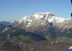
The Tournette (2,351 m) is a mountain in the Bornes Massif in Haute-Savoie, France. It is the highest of the mountains surrounding Lake Annecy and has a prominence of 1,514m, qualifying it as an Ultra.
It is possible to drive most of the way up, parking at Chalet De L'Aulp. From here the summit can be reached via a well marked path in around 3 hours. The final third of the climb requires some scrambling, but there are chains and ladders in all the difficult sections.
See also
References
- 1 2 3 "Europe Ultra-Prominences". Peaklist.org. Retrieved 2012-10-29.
External links
This article is issued from
Wikipedia.
The text is licensed under Creative Commons - Attribution - Sharealike.
Additional terms may apply for the media files.