Touqianzhuang MRT station
Touqianzhuang O17 頭前庄 | |
|---|---|
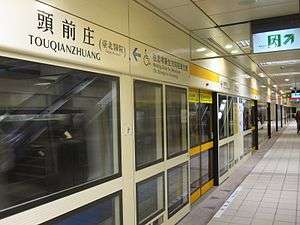 Touqianzhuang station platform 2 | |
| Other names | Taipei Hospital; 臺北醫院 |
| Location |
B1, No. 18, Siyuan Rd. Xinzhuang, New Taipei Taiwan |
| Operated by | |
| Line(s) |
|
| Connections | Bus stop |
| Construction | |
| Structure type | Underground |
| History | |
| Opened | 5 January 2012 |
| Traffic | |
| Passengers |
9,200 daily (2016)[1] (Ranked 98th of 109) |
| Touqianzhuang MRT station | |||||||||||
| Traditional Chinese | 頭前庄站 | ||||||||||
|---|---|---|---|---|---|---|---|---|---|---|---|
| Simplified Chinese | 头前庄站 | ||||||||||
| |||||||||||
The Taipei Metro Touqianzhuang station is a station on the Xinzhuang Line and a planned transfer station with the future Circular Line located in Xinzhuang District, New Taipei, Taiwan.[2] The station opened for service on 5 January 2012.[3]
Station overview
This three-level, underground station has an island platform.[4] It is located beneath the intersection of Zhongzheng Rd. and Siyuan Rd. It was scheduled to open in March 2012 along with most of the Xinzhuang Line,[5] but opened earlier for service on 5 January 2012.[3]
It is a planned transfer station with the Circular Line, which will have an elevated platform. It is scheduled to open in 2015.[6]
Construction
Excavation depth for this station is 24.53 to 25.13 m (80.5 to 82.4 ft). It is 170.85 m (560.5 ft) in length and 17.85 m (58.6 ft) wide. The platform is 141 m (463 ft) meters long.[7] It has six entrances, one accessibility elevator, and two vent shafts.[4] Two of the entrances are connected with an existing pedestrian underpass.
The station is constructed under the existing Siyuan Road pedestrian passage. In addition, the location of the station includes many utility pipelines that could not be relocated. Thus, due to the limited construction area, the station was not constructed using the cut-and-cover method employed in other stations. Instead, construction used the pipe jacking method from sidewalks, outer lanes of roads, and the spaces between Dahan Bridge piers.[8]
Design
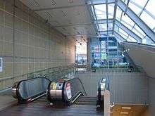
The theme for the station is "Thousands of sails: North Taiwan's Xinzhuang port".[9] Entrances are constructed from glass, steel frames, aluminum plates, and metal.
Station layout
| Street Level | Entrance/Exit | Entrance/Exit |
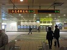
| B1 | Concourse | Lobby, information desk, automatic ticket dispensing machines, one-way faregates |
| Restrooms (Outside fare zone near exit 1) | ||
| B3 | Platform 1 | ← |
| Island platform, doors will open on the left | ||
| Platform 2 | → | |
Exits
- Exit 1: No. 18, Siyuan Rd., near Zhongzheng Rd.

- Exit 2: Zhongzheng Rd., near Dahan Bridge
- Exit 3: Zhongzheng Rd.
- Exit 4: Zhongzheng Rd., near Huacheng Rd.
Around the station
- Taipei Hospital
- IKEA, Xinzhuang Branch
- Hetai Auto Co., Xinzhuang Research Center
- Dahan Bridge
| Preceding station | Following station | |||
|---|---|---|---|---|
| Xinzhuang | Zhonghe–Xinlu line | Xianse Temple towards Nanshijiao | ||
|- | | Future service |
|}
References
| Wikimedia Commons has media related to Touqianzhuang Station. |
- ↑ "Passenger Volume at Taipei Rapid Transit Stations" (PDF). Taipei City Department of Transportation. 2017-03-13. Retrieved 2017-03-13.
- ↑ "Touqianzhuang". Taipei Rapid Transit Corporation. Retrieved 2012-01-07.
- 1 2 "MRT Xinzhuang line begins commercial service". Focus Taiwan News Channel. 2012-01-05. Retrieved 2012-01-05.
- 1 2 "Introduction to Xinzhuang MRT Line" (PDF). Department of Rapid Transit Systems. 2008-03-01. Archived from the original (PDF) on 2013-09-21. Retrieved 2010-06-17.
- ↑ 黃村杉 (2010-03-18). "北縣/捷運新莊線搶先通 市民「樂」官員「愁」". NOWnews. Retrieved 2010-06-22.
- ↑ "環狀線第一階段簡介" (PDF). Department of Rapid Transit System. 2009-12-01. Archived from the original (PDF) on 2016-03-03. Retrieved 2010-06-23.
- ↑ "捷運車站建築設計 後續路網 新莊線-縣轄段各車站透視圖說明". Department of Rapid Transit Systems. Retrieved 2010-08-01.
- ↑ "Pipe Jacking Method Applied to Underground Pedestrian Passage". Department of Rapid Transit Systems. 2011-07-01. Retrieved 2011-07-22.
- ↑ "( O3 ) Touqianzhuang". Comprehensive Planning Division, Civil Engineering and Architectural Design Division. 2008-11-19. Retrieved 2010-08-17.
| Stations |
| ||||||
|---|---|---|---|---|---|---|---|
| Rolling stock |
| ||||||
Coordinates: 25°02′21″N 121°27′38″E / 25.0392°N 121.4606°E