Tomah, Wisconsin
| Tomah | |
|---|---|
| City | |
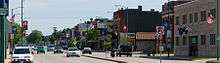
 Downtown Tomah | |
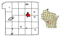 Location of Tomah in Monroe County, Wisconsin. | |
 Tomah Location within the state of Wisconsin | |
| Coordinates: 43°59′6″N 90°30′14″W / 43.98500°N 90.50389°WCoordinates: 43°59′6″N 90°30′14″W / 43.98500°N 90.50389°W | |
| Country | United States |
| State | Wisconsin |
| County | Monroe |
| Government | |
| • Mayor | Mike Murray |
| Area[1] | |
| • Total | 7.86 sq mi (20.36 km2) |
| • Land | 7.46 sq mi (19.32 km2) |
| • Water | 0.40 sq mi (1.04 km2) |
| Population (2010)[2] | |
| • Total | 9,093 |
| • Estimate (2016)[3] | 9,405 |
| • Density | 1,218.9/sq mi (470.6/km2) |
| Time zone | UTC-6 (Central (CST)) |
| • Summer (DST) | UTC-5 (CDT) |
| ZIP codes | 54660 |
| Area code(s) | 608 |
| FIPS code | 55-80075 |
| Website | www.tomahonline.com |
Tomah is a city in Monroe County, Wisconsin, United States. The population was 9,093 as of the 2010 census. The city is surrounded by the Town of Tomah and the Town of La Grange.
History
Tomah was founded by Robert E. Gillett in 1855[4][5] and incorporated as a city in 1883[6] but the charter was not issued until 1894.[7] Tomah is named after Thomas Carron (ca. 1752–1817), a trader at Green Bay who had integrated into the Menominee tribe.[8] The Menominees pronounced the name Tomah or Tomau and he became known as Chief Tomah. Tomah was adopted as the name for the settlement in Monroe County on the unsubstantiated belief that Chief Tomah had once held a tribal gathering in the area.[9]
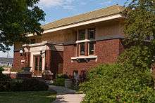
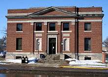
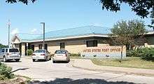
Tomah has two landmarks on the National Register of Historic Places: the old Tomah Post Office[10] at 903 Superior Avenue and the Tomah Public Library[11] at 716 Superior Avenue.
Geography
Tomah is located on the South Fork of the Lemonweir River,[12] a main tributary of the Lemonweir River, which is a large tributary of the lower Wisconsin River. The river is impounded on the west side of the city, forming Lake Tomah. Council Creek flows north through the east side of the city to meet the river.
The city is at the boundary between the hills of the Driftless Area in southwest Wisconsin and the flat, sandy, poorly drained ancient bed of Glacial Lake Wisconsin extending to the north and east of the city. The city's geographic coordinates are 43°59′6″N 90°30′14″W / 43.98500°N 90.50389°W (43.985089, -90.503922).[13]
According to the United States Census Bureau, the city has a total area of 7.86 square miles (20.36 km2), of which, 7.46 square miles (19.32 km2) is land and 0.40 square miles (1.04 km2) is water.[1]
Demographics
| Historical population | |||
|---|---|---|---|
| Census | Pop. | %± | |
| 1870 | 837 | — | |
| 1880 | 1,245 | 48.7% | |
| 1890 | 2,199 | 76.6% | |
| 1900 | 2,840 | 29.1% | |
| 1910 | 3,419 | 20.4% | |
| 1920 | 3,257 | −4.7% | |
| 1930 | 3,354 | 3.0% | |
| 1940 | 3,817 | 13.8% | |
| 1950 | 4,760 | 24.7% | |
| 1960 | 5,321 | 11.8% | |
| 1970 | 5,647 | 6.1% | |
| 1980 | 7,204 | 27.6% | |
| 1990 | 7,570 | 5.1% | |
| 2000 | 8,419 | 11.2% | |
| 2010 | 9,093 | 8.0% | |
| Est. 2016 | 9,405 | [3] | 3.4% |
| U.S. Decennial Census[14] | |||
2010 census
As of the census[2] of 2010, there were 9,093 people, 3,900 households, and 2,194 families residing in the city. The population density was 1,218.9 inhabitants per square mile (470.6/km2). There were 4,196 housing units at an average density of 562.5 per square mile (217.2/km2). The racial makeup of the city was 90.9% White, 2.6% African American, 1.7% Native American, 1.2% Asian, 0.3% Pacific Islander, 1.1% from other races, and 2.2% from two or more races. Hispanic or Latino of any race were 4.0% of the population.
There were 3,900 households of which 31.3% had children under the age of 18 living with them, 38.3% were married couples living together, 13.0% had a female householder with no husband present, 5.0% had a male householder with no wife present, and 43.7% were non-families. 37.6% of all households were made up of individuals and 14.4% had someone living alone who was 65 years of age or older. The average household size was 2.25 and the average family size was 2.96.
The median age in the city was 38 years. 24.9% of residents were under the age of 18; 7.5% were between the ages of 18 and 24; 26.3% were from 25 to 44; 26.2% were from 45 to 64; and 15.2% were 65 years of age or older. The gender makeup of the city was 50.2% male and 49.8% female.
2000 census
As of the census[15] of 2000, there were 8,419 people, 3,451 households, and 2,098 families residing in the city. The population density was 1,148.2 people per square mile (443.5/km²). There were 3,706 housing units at an average density of 505.4 per square mile (195.2/km²). The racial makeup of the city was 94.95% White, 1.03% Black or African American, 1.65% Native American, 0.67% Asian, 0.08% Pacific Islander, 0.46% from other races, and 1.15% from two or more races. 1.41% of the population were Hispanic or Latino of any race.
There were 3,451 households out of which 31.7% had children under the age of 18 living with them, 45.2% were married couples living together, 11.4% had a female householder with no husband present, and 39.2% were non-families. 33.6% of all households were made up of individuals and 15.0% had someone living alone who was 65 years of age or older. The average household size was 2.31 and the average family size was 2.96.
In the city, the population was spread out with 25.8% under the age of 18, 8.0% from 18 to 24, 26.5% from 25 to 44, 22.0% from 45 to 64, and 17.7% who were 65 years of age or older. The median age was 38 years. For every 100 females, there were 97.9 males. For every 100 females age 18 and over, there were 95.2 males.
The median income for a household in the city was $31,986, and the median income for a family was $42,881. Males had a median income of $31,612 versus $21,377 for females. The per capita income for the city was $17,409. About 8.4% of families and 12.7% of the population were below the poverty line, including 18.7% of those under age 18 and 6.3% of those age 65 or over.
Transportation
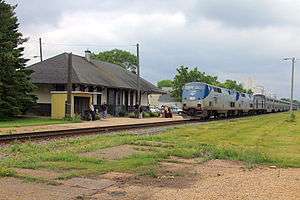
Tomah is a regional transportation hub because of its location where Interstate 90 and Interstate 94 diverge, with Interstate 90 continuing west to La Crosse, Wisconsin and Interstate 94 heading north to Eau Claire, Wisconsin and the Twin Cities. Tomah-Sparta Raceway (formerly known as Veterans Raceway and Excalibur Speedway) is a 3/8 mile asphalt oval track located about 3 miles (5 km) west of Tomah on WIS 21.[16] Tomah is served by an Amtrak Station on the Empire Builder route.
Airport
Bloyer Field airport (Y72) serves the city and is located 1 mile east of Tomah.
Education
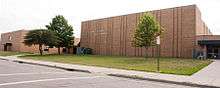
Tomah is served by the Tomah Area School District, which has more than 3,000 students. The district administers seven elementary schools, a middle school, a high school, an alternative school, and a Montessori Public Charter School (grades 4K-3).
Elementary schools
- Camp Douglas Elementary (grades 3-5)
- LaGrange Elementary (grades 4K-5)
- Lemonweir Elementary (grades 4K-5)
- Miller Elementary (grades K-5)
- Oakdale Elementary (grades 4K-2)
- Tomah Area Montessori School (grades 4K-4)
- Warrens Elementary (grades 4K-5)
- Wyeville Elementary (grades K-5)
Middle school
- Tomah Middle School (grades 6-8)
High School
- Tomah High School (grades 9-12)
Alternative school
- Robert Kupper Learning Center (grade 6-age 20)
There are two private schools in Tomah: Queen of the Apostles (grades 4K-8) and St. Paul Lutheran School[17] of the Wisconsin Evangelical Lutheran Synod (grades preK-8).
Health and medical
Four health care facilities are located in Tomah: Tomah Memorial Hospital, a Veteran's Administration Medical Center, Lake Tomah Clinic of Franciscan Skemp Mayo Health System, and the Tomah Clinic of Gundersen Lutheran.[18]
Parks and recreation
Tomah has 11 parks, a citywide recreation trail, and an aquatic center. The Tomah Parks and Recreation Department administers recreational programs for youth and adults.
Notable people
- Adelbert Bleekman, Wisconsin State Senator
- Herbert Eugene Bolton, Spanish borderlands scholar and director of the Bancroft Library, graduated from Tomah High School
- Charles K. Erwin, Wisconsin State Senator
- Anne Nicol Gaylor, advocate
- Glenn L. Henry, lawyer and member of the Wisconsin State Assembly[19]
- Jay R. Hinckley, member of the Wisconsin State Assembly
- Miles Hineman, member of the Wisconsin State Assembly
- William Washington Howes, first Assistant Postmaster General of the United States
- Kyle Kenyon, lawyer and legislator[20]
- Frank King, creator of the comic strip Gasoline Alley, grew up in Tomah.
- Thomas McCaul, mayor of Tomah
- Frank Augustus Miller, builder of the Mission Inn in Riverside, California
- Lewis T. Mittness, member of the Wisconsin State Assembly
- Charles Quigg, member of the Wisconsin State Assembly and physician[21]
- Arthur Claude Ruge, engineer
- John Emmet Sheridan, illustrator, was born in Tomah.
- Kenneth E. Stumpf, Congressional Medal of Honor recipient
- Ed Thompson, mayor of Tomah, Wisconsin gubernatorial candidate, State Senate candidate
- Bert D. Thorp, member of the Wisconsin State Assembly
- James Tormey, member of the Wisconsin State Assembly
References
- 1 2 "US Gazetteer files 2010". United States Census Bureau. Archived from the original on 2012-07-14. Retrieved 2012-11-18.
- 1 2 "American FactFinder". United States Census Bureau. Retrieved 2012-11-18.
- 1 2 "Population and Housing Unit Estimates". Retrieved June 9, 2017.
- ↑ Wisconsin Historical Society. "Tomah, Wisconsin - A Brief History". Retrieved 2015-12-20.
- ↑ History of Northern Wisconsin, Containing an Account of Its Settlement, Growth, Development, and Resources. Chicago: Western Historical Company. 1881. p. 643. Retrieved 2015-12-20.
- ↑ "An act to incorporate the City of Tomah" (PDF). Municipal Records (State of Wisconsin). Office of the Secretary of State (State of Wisconsin). 1883. Retrieved 2015-12-20.
- ↑ "Certificate of Adoption (Charter Issued)" (PDF). Municipal Records (State of Wisconsin). Secretary of State (State of Wisconsin). 1894-10-15. Retrieved 2015-12-20.
- ↑ "History of Chief Tomah". The Tomah Journal. July 11, 1924. Retrieved 2015-12-20.
- ↑ Vogel, Virgil J. Indian Names on Wisconsin's Map. Madison: University of Wisconsin Press, 1991, p. 42.
- ↑ "National Register Digital Assets: Tomah Post Office". National Register of Historic Places. National Park Service. 2000. Retrieved 2015-12-20.
- ↑ "National Register Digital Assets: Tomah Public Library". National Register of Historic Places. National Park Service. 2000. Retrieved 2015-12-20.
- ↑ "Little Lemonweir River Watershed" (PDF). Wisconsin Department of Natural Resources. 2002. p. 411. Retrieved 2015-12-20.
- ↑ "US Gazetteer files: 2010, 2000, and 1990". United States Census Bureau. 2011-02-12. Retrieved 2011-04-23.
- ↑ "Census of Population and Housing". Census.gov. Retrieved June 4, 2015.
- ↑ "American FactFinder". United States Census Bureau. Retrieved 2008-01-31.
- ↑ "Tomah-Sparta Raceway". Racingin. Retrieved March 19, 2015.
- ↑ "St Paul Lutheran School".
- ↑ Welcome to the Tomah VA Medical Center
- ↑ 'Wisconsin Blue Book 1960,' Biographical Sketch of Glenn L. Henry, p. 35.
- ↑ 'Wisconsin Blue Book 1970,' Biographical Sketch of Kyle Kenyon, p. 58.
- ↑ 'Wisconsin Blue Book 1893,' Biographical Sketch of Charles Quigg, p. 648.
External links
| Wikimedia Commons has media related to Tomah, Wisconsin. |
| Wikivoyage has a travel guide for Tomah. |
Municipalities and communities of Monroe County, Wisconsin, United States | ||
|---|---|---|
| Cities | 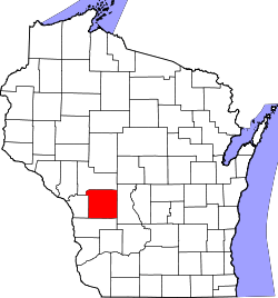 | |
| Villages | ||
| Towns | ||
| CDPs | ||
| Unincorporated communities | ||
| Indian reservation | ||
| Footnotes | ‡This populated place also has portions in an adjacent county or counties | |