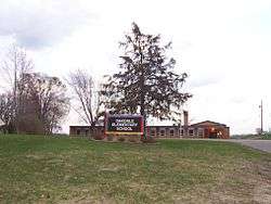
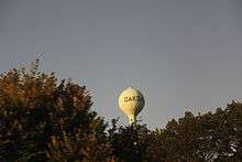
Oakdale, Wisconsin
| Oakdale, Wisconsin | |
|---|---|
| Village | |
 | |
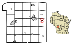 Location of Oakdale in Monroe County, Wisconsin. | |
| Coordinates: 43°56′45″N 90°22′10″W / 43.94583°N 90.36944°WCoordinates: 43°56′45″N 90°22′10″W / 43.94583°N 90.36944°W | |
| Country | United States |
| State | Wisconsin |
| County | Monroe |
| Area[1] | |
| • Total | 0.86 sq mi (2.23 km2) |
| • Land | 0.86 sq mi (2.23 km2) |
| • Water | 0 sq mi (0 km2) |
| Elevation[2] | 948 ft (289 m) |
| Population (2010)[3] | |
| • Total | 297 |
| • Estimate (2016)[4] | 296 |
| • Density | 345.3/sq mi (133.3/km2) |
| Time zone | UTC-6 (Central (CST)) |
| • Summer (DST) | UTC-5 (CDT) |
| Area code(s) | 608 |
| FIPS code | 55-58875[5] |
| GNIS feature ID | 1583837[2] |
Oakdale is a village in Monroe County, Wisconsin, United States. The population was 402 at the 2010 census. The village is located within the Town of Oakdale.
Geography
Oakdale is located at 43°57′32″N 90°22′43″W / 43.95889°N 90.37861°W (43.958986, -90.378844).[6]
According to the United States Census Bureau, the village has a total area of 0.86 square miles (2.23 km2), all of it land.[1]
Demographics
| Historical population | |||
|---|---|---|---|
| Census | Pop. | %± | |
| 1990 | 162 | — | |
| 2000 | 297 | 83.3% | |
| 2010 | 297 | 0.0% | |
| Est. 2016 | 296 | [4] | −0.3% |
| U.S. Decennial Census[7] | |||
2010 census
As of the census[3] of 2010, there were 297 people, 129 households, and 75 families residing in the village. The population density was 345.3 inhabitants per square mile (133.3/km2). There were 137 housing units at an average density of 159.3 per square mile (61.5/km2). The racial makeup of the village was 98.3% White, 0.7% African American, 0.7% Native American, and 0.3% Asian.
There were 129 households of which 30.2% had children under the age of 18 living with them, 42.6% were married couples living together, 9.3% had a female householder with no husband present, 6.2% had a male householder with no wife present, and 41.9% were non-families. 32.6% of all households were made up of individuals and 11.6% had someone living alone who was 65 years of age or older. The average household size was 2.30 and the average family size was 2.96.
The median age in the village was 39.8 years. 25.3% of residents were under the age of 18; 5% were between the ages of 18 and 24; 26.7% were from 25 to 44; 27.6% were from 45 to 64; and 15.5% were 65 years of age or older. The gender makeup of the village was 50.8% male and 49.2% female.
2000 census
As of the census[5] of 2000, there were 297 people, 112 households, and 73 families residing in the village. The population density was 352.9 people per square mile (136.5/km²). There were 127 housing units at an average density of 150.9 per square mile (58.4/km²). The racial makeup of the village was 98.65% White, 0.34% Native American, and 1.01% from two or more races. 0.34% of the population were Hispanic or Latino of any race.
There were 112 households out of which 31.3% had children under the age of 18 living with them, 47.3% were married couples living together, 9.8% had a female householder with no husband present, and 34.8% were non-families. 23.2% of all households were made up of individuals and 8.9% had someone living alone who was 65 years of age or older. The average household size was 2.65 and the average family size was 3.07.
In the village, the population was spread out with 27.3% under the age of 18, 6.7% from 18 to 24, 35.7% from 25 to 44, 18.9% from 45 to 64, and 11.4% who were 65 years of age or older. The median age was 35 years. For every 100 females, there were 106.3 males. For every 100 females age 18 and over, there were 109.7 males.
The median income for a household in the village was $35,500, and the median income for a family was $36,667. Males had a median income of $30,833 versus $20,250 for females. The per capita income for the village was $14,440. About 4.7% of families and 9.6% of the population were below the poverty line, including 12.1% of those under the age of eighteen and none of those sixty five or over.
References
| Wikimedia Commons has media related to Oakdale, Wisconsin. |
- 1 2 "US Gazetteer files 2010". United States Census Bureau. Archived from the original on January 24, 2012. Retrieved 2012-11-18.
- 1 2 "US Board on Geographic Names". United States Geological Survey. 2007-10-25. Retrieved 2008-01-31.
- 1 2 "American FactFinder". United States Census Bureau. Retrieved 2012-11-18.
- 1 2 "Population and Housing Unit Estimates". Retrieved June 9, 2017.
- 1 2 "American FactFinder". United States Census Bureau. Archived from the original on September 11, 2013. Retrieved 2008-01-31.
- ↑ "US Gazetteer files: 2010, 2000, and 1990". United States Census Bureau. 2011-02-12. Retrieved 2011-04-23.
- ↑ "Census of Population and Housing". Census.gov. Archived from the original on May 12, 2015. Retrieved June 4, 2015.
Municipalities and communities of Monroe County, Wisconsin, United States | ||
|---|---|---|
| Cities | 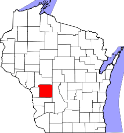 | |
| Villages | ||
| Towns | ||
| CDPs | ||
| Unincorporated communities | ||
| Indian reservation | ||
| Footnotes | ‡This populated place also has portions in an adjacent county or counties | |