Tolnanémedi
| Tolnanémedi | ||
|---|---|---|
| ||
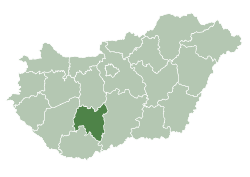
 Tolnanémedi Location of Tolnanémedi in Hungary | ||
| Coordinates: 46°42′55″N 18°28′33″E / 46.71528°N 18.47583°ECoordinates: 46°42′55″N 18°28′33″E / 46.71528°N 18.47583°E | ||
| Country | Hungary | |
| Region | Southern Transdanubia | |
| County | Tolna | |
| Area[1] | ||
| • Total | 21.10 km2 (8.15 sq mi) | |
| Population (2011)[2] | ||
| • Total | 1,079 | |
| • Density | 51/km2 (130/sq mi) | |
| Time zone | UTC+1 (CET) | |
| • Summer (DST) | UTC+2 (CEST) | |
| Postal code | 7083 | |
| Area code | +36 74 | |

Tolnanémedi is a village in Tolna county, Hungary.
References
- ↑ Tolnanémedi at the Hungarian Central Statistical Office (Hungarian).
- ↑ Tolnanémedi at the Hungarian Central Statistical Office (Hungarian). 2011
| City with county rights |
|   |
|---|---|---|
| Towns | ||
| Large villages | ||
| Villages |
| |
| Other topics |
| |
This article is issued from
Wikipedia.
The text is licensed under Creative Commons - Attribution - Sharealike.
Additional terms may apply for the media files.