Bátaszék
| Bátaszék | ||
|---|---|---|
| ||
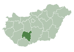
 Bátaszék Location of Bátaszék | ||
| Coordinates: 46°11′33″N 18°43′21″E / 46.19248°N 18.72258°ECoordinates: 46°11′33″N 18°43′21″E / 46.19248°N 18.72258°E | ||
| Country |
| |
| County | Tolna | |
| Area | ||
| • Total | 63.54 km2 (24.53 sq mi) | |
| Population (2015) | ||
| • Total | 6,217 | |
| • Density | 98/km2 (250/sq mi) | |
| Time zone | UTC+1 (CET) | |
| • Summer (DST) | UTC+2 (CEST) | |
| Postal code | 7140 | |
| Area code(s) | 74 | |
Bátaszék (German: Badeseck, Serbian: Батсек, translit. Batsek) is a town in Tolna County, Hungary. Majority residents are Hungarians, with minority of Serbs.
"The oldest tree of Bátaszék" won the title of European Tree of the Year 2016.[1]
History
During World War II, Bátaszék was captured on 28 November 1944 by Soviet troops of the 3rd Ukrainian Front in the course of the Budapest Offensive.
Twin towns — sister cities
Bátaszék is twinned with:


Gallery
 Roman Catholic Church in Bátaszék
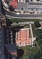 View at the site of the Cikádor Abbey
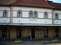 Bátaszék railway station
 "The oldest tree of Bátaszék", European Tree of the Year 2016.
References
- ↑ "Previous years and their winners". Environmental Partnership Association. Retrieved 30 April 2017.
External links
| Wikimedia Commons has media related to Bátaszék. |
- Street map (in Hungarian)
| City with county rights |
|   |
|---|---|---|
| Towns | ||
| Large villages | ||
| Villages |
| |
| Other topics |
| |
This article is issued from
Wikipedia.
The text is licensed under Creative Commons - Attribution - Sharealike.
Additional terms may apply for the media files.