Lengyel
| Lengyel Lendl | |
|---|---|
| Village | |
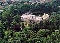
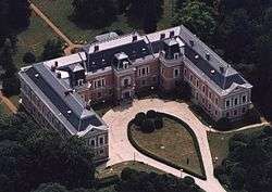 Aerial photography: Lengyel, Appony Manor House | |
 Lengyel Lendl Location of Lengyel | |
| Coordinates: 46°22′12″N 18°22′01″E / 46.37°N 18.367°ECoordinates: 46°22′12″N 18°22′01″E / 46.37°N 18.367°E | |
| Country |
|
| Region | Southern Transdanubia |
| County | Tolna |
| Subregion | Bonyhádi |
| Area | |
| • Total | 20.03 km2 (7.73 sq mi) |
| Population (2004) | |
| • Total | 652 |
| • Density | 26.41/km2 (68.4/sq mi) |
| Time zone | UTC+1 (CET) |
| • Summer (DST) | UTC+2 (CEST) |
| Postal code | 7184 |
| Area code(s) | 74 |
Lengyel (literally: "Pole", German: Lendl) is the highest inhabited village in Tolna County, Hungary. It is located between Bonyhád and Dombóvár.
Lengyel culture is named after the village.
Cultural events
- Annabál
- Pollen Youth Rock Festival
Notable aspects
- Apponyi manor house surrounded by 22 hectares of park with botanical rarities.
- Kindergarten museum
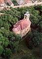
- Svájceráj (a stable built in the Swiss fashion from the 19th century)
- Apponyi basement
- The post office and kindergarten building (The first Apponyi manor house, which is smaller in size)
- Anna Bath - With 100 hectares of forested park, a school, a lake, and a small zoo.
- Sánci Peak (A historical area protected by Mór Wosinsky) with a beautiful panorama of the Kapos Valley.
People
- Sándor Apponyi
- János Bogdán (hu)
- József Cserháti (hu)
- Mór Wosinsky (hu)
After approximately 200 years of residency, Lengyel's ethnic German Danube Swabian population was dispossessed of its property and forcibly removed to Germany following the end of World War II.
References
External links
This article is issued from
Wikipedia.
The text is licensed under Creative Commons - Attribution - Sharealike.
Additional terms may apply for the media files.