Togdheer
| Togdheer | |
|---|---|
| Region | |
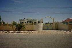 A residential area in Burao. | |
 Location in Somalia | |
| Country |
De jure |
| Capital | Burao |
| Time zone | UTC+3 (EAT) |
Togdheer (Somali: Togdheer, Arabic: تُوجدَير) is an administrative region (gobol) in northern Somalia, although it is de facto part of the Somaliland region, a self-declared state but internationally unrecognized.[1][2]
Overview
Togdheer is bordered by Woqooyi Galbeed from the north & west, while Ethiopia to the south, and eastern side of the regions of Sanaag and Sool. With its capital at Burao (Burco), the region's name is derived from the Togdheer River, which means "Long River" in Somali.
As with much of Somaliland, most local residents in the Togdheer region are nomadic pastoralists.[3]
Territorial dispute
The Buuhoodle District are disputed between the Somaliland government, and the government of the autonomous Puntland state of Somalia. Both recognize the district as the region named Ayn.
Districts
The Togdheer region consists of the following four districts:[4]
Demographics
It is equally shared & dominated by Habar Yoonis, Issa Musse & Habar Jeclo sub-divisions of Isaaq well represented. The Dhulbahante of the Harti, Darod clan is also well represented in the Buuhoodle district. [5][6]
Major towns
Notes
- ↑ Regions of Somalia
- ↑ "Somalia". The World Factbook. Langley, Virginia: Central Intelligence Agency. Retrieved 6 December 2013.
- ↑ Bradbury, Mark (2008). Becoming Somaliland. Progressio. p. 201. ISBN 0253351782.
- ↑ "Districts of Somalia". Statoids. Retrieved 6 December 2013.
- ↑ Hoehne, Markus V. Borders & Borderlands as resources in the Horn of Africa. p. 113. Retrieved 14 November 2017.
- ↑ Gebrewold, Belachew. Anatomy of Violence: Understanding the systems of conflict and violence in Africa. Ashgate Publishing Ltd. p. 130. Retrieved 14 November 2017.
External links
- Administrative map of Togdheer
- Togdheer News Network (in Somali)
| History |
|  | |||||||
|---|---|---|---|---|---|---|---|---|---|
| Geography |
| ||||||||
| Politics |
| ||||||||
| Economy | |||||||||
| Society |
| ||||||||
| |||||||||