Titsey
| Titsey | |
|---|---|
 Titsey Place is the surviving manor of Titsey but a stately home that is open for visitors and is charitably run | |
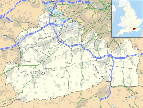 Titsey Titsey shown within Surrey | |
| Area | 10.99 km2 (4.24 sq mi) |
| Population | 272 (Civil Parish 2011)[1] |
| • Density | 25/km2 (65/sq mi) |
| OS grid reference | TQ4157 |
| • London | 16 mi (26 km) NNE |
| Civil parish |
|
| District | |
| Shire county | |
| Region | |
| Country | England |
| Sovereign state | United Kingdom |
| Post town | WESTERHAM |
| Postcode district | TN16 |
| Post town | OXTED |
| Postcode district | RH8 |
| Dialling code | 01959 |
| Police | Surrey |
| Fire | Surrey |
| Ambulance | South East Coast |
| EU Parliament | South East England |
| UK Parliament | |
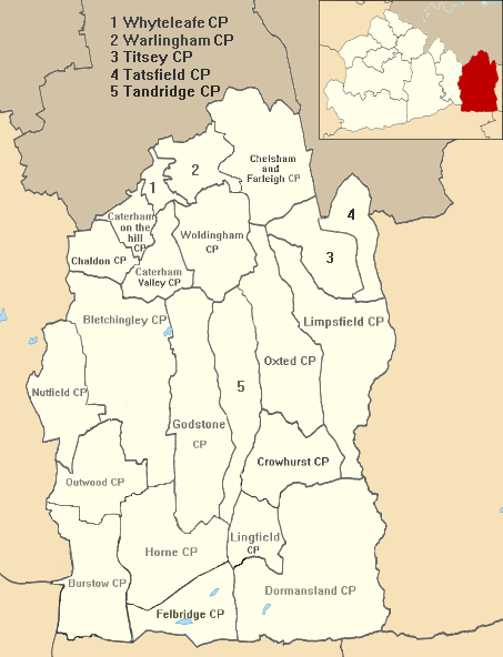
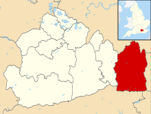
Titsey is a rural village and a civil parish on the North Downs almost wholly within the M25 London Orbital Motorway in the Tandridge District of Surrey, England.
In local government it forms the south-western part of the ward Tatsfield and Titsey and in national statistics approximates to output area E00157289. It has no railway stations however one is centred 1.5 miles (2.4 km) south-west, Oxted which also has the administrative centre of the district. Approximately half of it land is owned by a charity running the Titsey Place estate, with the remainder being a mixture of common and privately owned woodland and smallholdings.
History
The village lay within the Tandridge hundred, of greatest use in the Anglo-Saxon Kingdom of England and it continues to form a parish in the church of England until its church became appropriated by that of Tatsfield.[3]
The eastern parish boundary follows the London to Lewes Way Roman road which descends the escarpment of the North Downs here, crossing two important ancient east–west routes, the North Downs ridgeway and the Pilgrims Way on the lower slopes.[4]
Titsey appears in Domesday Book of 1086 as a village: Ticesei held by Haimo the Sheriff (of Kent) when its assets were: 2 hides; 1 church, 9 ploughs, pasture worth every seventh hog of the villains. It rendered £11 per year to its feudal system overlords.[5]
Demography and housing
| Output area | Detached | Semi-detached | Terraced | Flats and apartments | Caravans/temporary/mobile homes/houseboats | Shared between households[1] |
|---|---|---|---|---|---|---|
| E00157289 | 67 | 37 | 2 | 2 | 0 | 0 |
The average level of accommodation in the region composed of detached houses was 28%, the average that was apartments was 22.6%.
| Output area | Population | Households | % Owned outright | % Owned with a loan | hectares[1] |
|---|---|---|---|---|---|
| E00157289 | 272 | 108 | 36.1 | 23.1 | 1,099 |
The proportion of households who owned their home outright compares to the regional average of 35.1%. The proportion who owned their home with a loan compares to the regional average of 32.5%. The remaining % is made up of rented dwellings (plus a negligible % of households living rent-free).
In 2011 the ward of the United Kingdom, Tatsfield and Titsey, almost twice its size, had 1,816 inhabitants
Local government
Geography
Titsey covers a long tract which reaches up the southern escarpment of the North Downs, specifically to the highest point of the range, Botley Hill, which is in the parish. The north has altitude of around 230 metres (750 ft) where the North Downs Way passes through the parish. Springs in Titsey, rising at the foot of the chalk scarp of the North Downs, are the source of the River Eden.[8][9]
It is a dispersed settlement bordering Farleigh to the north and the London Borough of Bromley to the north-east. Biggin Hill is to the north-east, across the village centre of Tatsfield. The boundary with Kent is centred 1.5 miles (2.4 km) east. Titsey has two post towns depending on exact location.
References
- 1 2 3 Key Statistics; Quick Statistics: Population Density United Kingdom Census 2011 Office for National Statistics Retrieved 21 November 2013
- ↑ Margary, Ivan (1948). Roman Ways in the Weald (3 ed.). London: J. M. Dent. p. 133. OCLC 4611036.
- ↑ Tatsfield St Mary Church of England. Retrieved 31 December 2013
- ↑ Margary (1948: 130)
- ↑ Surrey Domesday Book Archived 15 July 2007 at the Wayback Machine.
- ↑ Tandridge Census Statistics
- ↑ Tandridge Borough Council
- ↑ Long, George; Porter, George (1850). The geography of Great Britain. London: Woodall. p. 50. OCLC 33113443.
- ↑ Wooldridge, Sidney; Hutchings, Geoffrey (1957). "The scarp-zone foot". London's Countryside: Geographical Field Work for Students and Teachers of Geography. London: Methuen. p. 153. OCLC 519129.
External links
![]()
- Explore Britain — Titsey Wood
- Parish Council Clerk — contact details
- Nore Hill Chalk Pinnacle - Surrey Wildlife Trust
| Settlements (grouped by associated post town) |
|  | ||||||||||||||||||
|---|---|---|---|---|---|---|---|---|---|---|---|---|---|---|---|---|---|---|---|---|
| Places of worship | ||||||||||||||||||||
| Education | ||||||||||||||||||||
| Transport |
| |||||||||||||||||||
| Buildings and structures |
| |||||||||||||||||||
| Sport |
| |||||||||||||||||||
The administrative centre is Oxted. The largest town is Caterham. Three of the post towns have urban centres Caterham, Godstone and Oxted. Lingfield and Warlingham are major villages which have post town status. The others are outside the area. | ||||||||||||||||||||