Småland
| Småland | ||
|---|---|---|
| ||
 | ||
| Country | Sweden | |
| Land | Götaland | |
| Counties |
Kronoberg County Kalmar County Jönköping County Halland County Östergötland County | |
| Area | ||
| • Total | 29,400 km2 (11,400 sq mi) | |
| Population (31 December 2016)[1] | ||
| • Total | 754,535 | |
| • Density | 26/km2 (66/sq mi) | |
| Ethnicity | ||
| • Language | Swedish | |
| • Dialect | Småländska | |
| • Demonym | Smålänning | |
| Culture | ||
| • Flower | Twinflower | |
| • Animal | Otter | |
| • Bird | Song thrush | |
| Time zone | UTC+1 (CET) | |
| • Summer (DST) | UTC+2 (CEST) | |
| Postal codes | 33000–34999, 35000–36999, 38000–39999, 55000–57999, 59000–59999 (shared with Östergötland) | |
| Area codes |
0372 0433 0459 0470–0478 0480–0493 | |
Småland (Swedish pronunciation: [ˈsmoːland] (![]()
Administration
The traditional provinces of Sweden serve no administrative or political purposes, but are historical and cultural entities. The province is divided into the three administrative counties: Jönköping County, Kalmar County and Kronoberg County, which roughly cover the entire Småland province. Smaller areas of Småland, however, are situated in Halland County and Östergötland County.
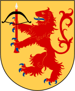
Heraldry
The current coat of arms, granted in 1569, features a rampant red lion on a golden shield carrying a crossbow. The arms may appear with a ducal coronet. Blazon: "Or a lion rampant Gules langued and armed Azure holding in front paws a Crossbow of the second bowed and stringed Sable with a bolt Argent."
Population
The population of Småland was 754,535 as of 31 December 2016, distributed over five counties as follows:[1]
| County | Population |
|---|---|
| Jönköping County, largely | 333,923 |
| Kalmar County, largely | 216,455 |
| Kronoberg County, entirely | 194,628 |
| Halland County, peripherally | 7,574 |
| Östergötland County, peripherally | 1,955 |
| Locality | Population |
|---|---|
| Jönköping | 89,396 |
| Växjö | 65,387 |
| Kalmar | 36,392 |
| Västervik | 21,140 |
| Värnamo | 18,696 |
| Oskarshamn | 17,258 |
| Nässjö | 16,678 |
| Ljungby | 15,205 |
| Tranås | 14,197 |
| Vetlanda | 13,050 |
| Nybro | 12,810 |
Geography

The geography is dominated by a forested high plain where the soil is mixed with sand and small boulders, making it barren in all except the coastal areas, and unsuited for agriculture except in certain locations, notably the Kalmar Plains. The province is rich in lakes and bogs. The coast consists of an archipelago of islands and bays in the north and cultivated flatlands in the south. In total, cultivated land covers 14%, meadows 7% and forest 50%.[3] Except for a lack of deep valleys the landscape is similar to the Norrland terrain found further north in Sweden.[4]
Largest towns are Jönköping in the north-west, Växjö in the south, and Kalmar on the east coast near Öland Island.
Terrain
Småland constitutes the central, eastern and southern parts of the South Swedish highlands. In detail the topography of Småland is that of a series of flat surfaces built-upon or deformed-by a geological dome.[5][6] The elevated terrain thought to be a buckle formed as result of far-away forces transmitted to Sweden.[7] The main surfaces are the Sub-Cambrian peneplain, the South Småland peneplain and the "200 m peneplain".[5][6] These surfaces and others are arranged in a stepped sequence called a piedmonttreppen.[6] In eastern Småland the Sub-Cambrian peneplain forms a gently east-dipping surface that reaches the sea.[5][upper-alpha 1] To the west this part of the Sub-Cambrian peneplain terminates along a north-south escarpment (runs slightly east of Växjö) that separates it from other flat surfaces.[5] Central and northwestern Småland contains strings of isolated hills.[5]
The lakes and rivers of Småland are associated to zones of weak rock, be it either fractures, weathered rock or both. The great number of lakes in Småland is indebted to the creation of basins due to the stripping of an irregular mantle of weathered rock by glacier erosion.[8] Lagan and Nissan drains western Småland following for most of their course zones of weak rock associated to the Protogine Zone.[5][9] The lakes Rusken, Rymmen and Möckeln are aligned with a more eastern branch of the Protogine Zone.[9] Canyons cut into the bedrock are common in central and northern Småland, with the area near Mörlunda containing various particularly narrow (<50 m) canyons.[10][11][upper-alpha 2]
Climate
The climate of Småland is divided between the oceanic climate of coastal areas such as Kalmar[12] and the humid continental climate of the interior higher areas such as Jönköping.[13] Southern interior areas such as Växjö have similar oceanic climates such as the coastline.[14] However, temperature average differences between areas are relatively small, since Småland lies in the continental/oceanic transition zone. Summer daytime averages are similar throughout the province, since according to Weatherbase all three major urban areas are on average around 21 °C (70 °F) with daytime winter temperatures hovering around the freezing point. The slightly colder nights averaging −5 °C (23 °F) in Jönköping are rendering its continental classification.[15] The locality of Målilla has the Swedish and Scandinavian all-time highest-measured temperature with 38 °C (100 °F) on June 1, 1947.[16]
History
The area was probably populated in the Stone Age from the south, by people moving along the coast up to Kalmar. Småland was populated by Stone Age peoples by at least 6000 BC, since the Alby People are known to have crossed the ice bridge across the Kalmar Strait at that time.
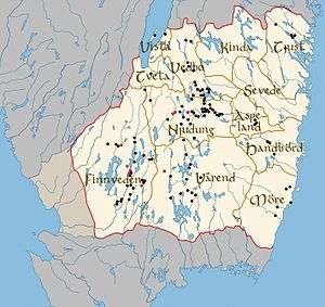
The name Småland ("small lands") comes from the fact that it was a combination of several independent lands, Kinda (today a part of Östergötland), Tveta, Vista, Vedbo, Tjust, Sevede, Aspeland, Handbörd, Möre, Värend, Finnveden and Njudung. Every small land had its own law in the Viking age and early middle age and could declare themselves neutral in wars Sweden was involved in, at least if the King had no army present at the parliamentary debate. Around 1350, in the reign of king Magnus Eriksson, the first national law code was introduced in Sweden, and the historic provinces lost much of their old autonomy.
The city of Kalmar is one of the oldest cities of Sweden, and in the medieval age it was the southernmost and the third largest city in Sweden, when it was a center for export of iron, which, in many cases, was handled by German merchants. At the time, Scania and Blekinge were not parts of Sweden.
Småland was the center of several peasant rebellions. The one closest to being successful was Dackefejden led by Nils Dacke in 1542–1543. When officials of king Gustav Vasa were assaulted and murdered, the king sent small expeditions to pacify the area, but all failed. Dacke was in reality the ruler of large parts of Småland during the winter, though heavily troubled by a blockade of supplies, before finally being defeated by larger forces attacking from both Västergötland and Östergötland. Dacke held a famous battle defence at the (now ruined) Kronoberg Castle, and was shot while trying to escape to then Danish-ruled Blekinge.
A geographical part of Småland called Kingdom of Crystal is known for its many glassworks and can be historically traced back to the 18th century.
In the 19th century, Småland was characterized by poverty, and had a substantial emigration to North America, which additionally hampered its development. The majority of emigrants ended up in Minnesota, with a geography resembling Sweden, combining arable land with forest and lakes. Many then moved to Stamford, Texas, recruited by the state's first Swedish immigrant, Swante M. Swenson, who had become a wealthy Texas magnate[17] and friend of Sam Houston.
The well known furniture company IKEA was founded in the Småland town of Älmhult.
Overnight between 8 and 9 January 2005 the province suffered serious damage from the storm Gudrun.
Historical cities
Towns with former city status were: Eksjö (chartered around 1400), Gränna (1652), Huskvarna (1911), Jönköping (1284), Kalmar (approximately 1100), Ljungby (1936), Nybro (1932), Nässjö (1914), Oskarshamn (1856), Sävsjö (1947), Tranås (1919), Vetlanda (1920), Vimmerby (approximately 1400), Värnamo (1920), Västervik (approximately 1200), Växjö (1342)
National parks
Småland has three national parks:
Religion

Compared to much of Sweden, Småland has a higher level of religious intensity and church participation.
In terms of Lutheran ecclesiastical boundaries, most of the province encompasses the diocese of Växjö. Parts of northern Småland are in the diocese of Linköping.
Småland is also known for its free churches, although the free church congregations are concentrated in Jönköping County. Most of Kalmar County and Kronoberg County have few or no free church congregations.
Politically Småland is the strongest province for Kristdemokraterna (the Swedish Christian Democratic Party), and both of the last two leaders of the party - Göran Hägglund and Alf Svensson live in Jönköping Municipality in northern Småland.
Culture
The Swedish botanist Carl Linnaeus, sw. Carl von Linné (1707–1778), often called the father of taxonomy or "The flower-king", was born in Älmhult in Småland. He gave the twinflower its Latin name based on his own (Latin: Linnaea borealis), because of his particular fondness of it. The flower has become Småland's provincial flower.
Another notable person from Älmhult is Ingvar Kamprad, the founder of the global company IKEA. The name "Småland" is used as the name of the children's play areas at some IKEA stores.
Education
Småland is home to the Linnaeus University, located in Växjö and Kalmar, and the Jönköping University.
Literature
The Swedish emigration to North America during the 19th century, is best depicted in a suite of novels by author Vilhelm Moberg, which is also the basis for the musical Kristina from Duvemåla created by Benny Andersson and Björn Ulvaeus of ABBA fame.
In her writing, children's book author Astrid Lindgren often portrayed scenes from her own childhood, growing up on a farm in Småland.
Smålandians
In the 20th century, Småland has been known for its high level of entrepreneurship and low unemployment, especially in the Gnosjö region.
Old Swedish encyclopedia Nordisk familjebok describes the inhabitants of Småland as follows:
- the Smålandian is by nature awake and smart, diligent and hard-working, yet compliant, cunning and crafty, which gives him the advantage of being able to move through life with little means. [18]
A running joke local to Sweden, is that Smålandians are very economical, ranging from modestly frugal to utterly cheap. Ingvar Kamprad said that the Smålandian are seen as the Scotsmen of Sweden.[19]
Language
The local language is a Swedish dialect known as Småländska (Smalandian). This may in turn be separated in two main branches, with the northern related to the Götaland dialects and the southern to the Scanian dialects.
Sub-divisions
For details, see: Districts of Småland
Small lands
After the unification of Sweden, around 800–1200 AD, Småland was for consistency divided into chartered cities and into hundreds.
Hundreds
The historical sub-divisions of all Sweden's provinces were through hundreds (Swedish: härad). These were Småland's hundreds:
- Allbo Hundred
- Aspeland Hundred
- Handbörd Hundred
- Kinda Hundred
- Kinnevald Hundred
- Konga Hundred
- Mo Hundred
- Möre Northern Hundred
- Möre Southern Hundred
- Norrvidinge Hundred
- Sevede Hundred
- Stranda Hundred
- Sunnerbo Hundred
- Tjust Northern Hundred
- Tjust Southern Hundred
- Tunalän Hundred
- Tveta Hundred
- Uppvidinge Hundred
- Vedbo Northern Hundred
- Vedbo Southern Hundred
- Vista Hundred
- Västbo Hundred
- Västra Hundred
- Ydre Hundred
- Östbo Hundred
- Östra Hundred
Towns in Småland
Sports
Football in the province is administered by Smålands Fotbollförbund.
See also
Notes
- ↑ Then the surface has a continuation as unconformity beneath Öland.[5]
- ↑ During deglaciation meltwater from the Weichsel ice flowed through the canyons contributing to their formation.[11]
References
- 1 2 "Folkmängd i landskapen den 31 december 2016" (in Swedish). Statistics Sweden. 21 March 2017. Retrieved 26 November 2017.
- ↑ Encyclopædia Britannica; Micropaedia Volume IX (1974) p. 278
- ↑ This figure is from Nordisk familjebok (see details and link below). A guess would be that meadows have decreased since.
- ↑ Lundqvist, Jan (1969). "Landskapet". In Lundqvist, Magnus. Det Moderna Sverige (in Swedish). Bonniers. pp. 64–67.
- 1 2 3 4 5 6 7 Lidmar-Bergström (1988). "Denudation surfaces of a shield area in southern Sweden". Geografiska Annaler. 70 A (4): 337–350.
- 1 2 3 Lidmar-Bergström, Karna; Olvmo, Mats; Bonow, Johan M. (2017). "The South Swedish Dome: a key structure for identification of peneplains and conclusions on Phanerozoic tectonics of an ancient shield". GFF.
- ↑ Japsen, Peter; Chalmers, James A.; Green, Paul F.; Bonow, Johan M. (2012). "Elevated, passive continental margins: Not rift shoulders, but expressions of episodic, post-rift burial and exhumation". Global and Planetary Change. 90–91: 73–86.
- ↑ Lidmar-Bergström, K.; Olsson, S.; Roaldset, E. (1999). "Relief features and palaeoweathering remnants in formerly glaciated Scandinavian basement areas". In Thiry, Médard; Simon-Coinçon, Régine. Palaeoweathering, Palaeosurfaces and Related Continental Deposits. Special publication of the International Association of Sedimentologists. 27. Blackwell Science Ltd. pp. 275–301. ISBN 0-632 -05311-9.
- 1 2 Andréasson, Per-Gunnar; Rodhe, Agnes (1992). The Protogine Zone. Geology and mobility during the last 1.5 Ga (PDF) (Report). SKB technical report.
- ↑ Persson, Torsten (1977). "Erosion channels and canyons in the central South Swedish Highlands — a short survey" (PDF). Bulletin of the Geological Society of Finland. 49: 11–18. Retrieved February 18, 2018.
- 1 2 Olvmo, M. (1992). "Glaciofluvial canyons and their relation to the Late Weiochselian deglaciation in Fennoscandia". Zeitschrift für Geomorphologie. 36 (3): 343–363.
- ↑ "Karlmar, Sweden Climate summary". Weatherbase. Retrieved 12 December 2014.
- ↑ "Jonkoping, Sweden Climate summary". Weatherbase. Retrieved 12 December 2014.
- ↑ "Vaxjo, Sweden Köppen Climate Classification". Weatherbase. Retrieved 12 December 2014.
- ↑ "Jonkoping, Sweden temperature averages". Weatherbase. Retrieved 12 December 2014.
- ↑ "Hur var vädret?". Swedish Meteorological and Hydrological Institute. Retrieved 12 December 2014.
- ↑ TSHA "Swenson, Swante Magnus, 1816-1896, Handbook of Texas), Texas State Historical Society.
- ↑ Smålänningen är till sin natur vaken och intelligent, flitig och sträfsam, rask och hurtig, men likväl foglig till lynnet, händig och slug, hvilket allt medför åt honom den förmånen, att han äfven med små medel kan taga sig fram i lifvet. . p.62; source as above.
- ↑ SSR TSR March 24, 2006
- article Småland from Nordisk Familjebok (1917). In Swedish.
External links
- Visit Småland - Official tourist site (Kronoberg and Jönköping counties)
- Eastern Småland and Öland - Official tourist site (Kalmar County)
- VisitSweden - Sweden's official website for tourism and travel information (in English)
- Travel Smaland