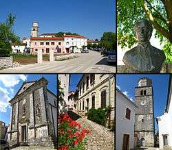
Tinjan
| Tinjan | ||
|---|---|---|
| Municipality | ||
 | ||
| ||
 Tinjan Location of Tinjan in Croatia | ||
| Coordinates: 45°13′02″N 13°50′20″E / 45.21722°N 13.83889°ECoordinates: 45°13′02″N 13°50′20″E / 45.21722°N 13.83889°E | ||
| Country | Croatia | |
| County | Istria | |
| Population (2011)[1] | ||
| • Total | 1,684 | |
| Time zone | UTC+1 (CET) | |
| • Summer (DST) | UTC+2 (CEST) | |
| Website | tinjan.hr | |

Tinjan (Italian: Antignana) is a village and municipality in Istria, Croatia. The total population is 1,684 (2011 census), distributed in the following settlements:[1]
- Brčići, population 100
- Brečevići, population 187
- Jakovici, population 268
- Kringa, population 315
- Muntrilj, population 77
- Radetići, population 210
- Tinjan, population 417
- Žužići, population 110
Tinjan is located is 50 km north of Pula and 10 km southwest of Pazin, in the Draga valley. The Coat of Arms of Tinjan is azure on a base vert a tower argent behind walls of the same. This is based on the historical pattern.
References
- 1 2 "Population by Age and Sex, by Settlements, 2011 Census: Tinjan". Census of Population, Households and Dwellings 2011. Zagreb: Croatian Bureau of Statistics. December 2012.
External links
| Wikimedia Commons has media related to Tinjan. |
Subdivisions of Istria County | ||
|---|---|---|
| Cities and towns | 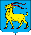 | |
| Municipalities | ||
This article is issued from
Wikipedia.
The text is licensed under Creative Commons - Attribution - Sharealike.
Additional terms may apply for the media files.