Brtonigla
| Brtonigla | |
|---|---|
| Municipality | |
|
Brtonigla Municipality Općina Brtonigla - Comune di Verteneglio[1] | |
 Church in Brtonigla/Verteneglio | |
 Brtonigla Location of Brtonigla in Croatia | |
| Coordinates: 45°23′N 13°38′E / 45.383°N 13.633°ECoordinates: 45°23′N 13°38′E / 45.383°N 13.633°E | |
| Country |
|
| County | Istria |
| Government | |
| • Municipal mayor | Doriano Labinjan |
| Area | |
| • Total | 32.72 km2 (12.63 sq mi) |
| Elevation | 141 m (463 ft) |
| Population (2011)[2] | |
| • Total | 1,626 |
| • Density | 50/km2 (130/sq mi) |
| Time zone | UTC+1 (CET) |
| • Summer (DST) | UTC+2 (CEST) |
| Website |
www |
Brtonigla (Italian: Verteneglio; Venetian: Vertenejo) is a town and municipality in the north-western part of Istria County, Croatia. Brtonigla/Verteneglio is a bilingual town; in 2011, 40% of the population declared themselves as ethnic Italians.[2]
Physical geography
Brtonigla was formerly part of the municipality of Buje, which is immediately north, and is bordered to the south by the River Quieto. The town of Brtonigla originally was placed on top of a hill but over time it extended to its sides occupying the entire hill. The area is suitable for agriculture. Wine, grain, corn, oil and vegetables are produced there. It is about 3km far from Buje while it is about 4km from the sea. The nearest seaside resort is Karigador. The summers are long and dry, while the winters are mild and pleasing.
History
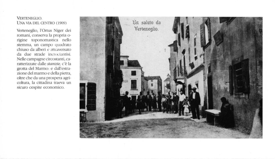
Brtonigla was mentioned for the first time in 1234, with the ancient name Ortoneglo or Hortus Niger, i.e. black ground garden.[3]
In the 11th century Venetians settled in the area, and in the 16th and 17th century Dalmatian and Balkan peasant families settled there too. Vertenejo was part of the Serenissima Republic of Venice and then of the Austro-Hungarian Empire, with the brief parenthesis of the Napoleonic Kingdom of Italy. After the First World War and then the Treaty of Rapallo, the village became part of Italy, a period in which Verteneglio knew its maximum demographic and economic development. After the Second World War it was included in Zone B of the Free Territory of Trieste. With the cession of Zone B to Yugoslavia, most of the Italian population abandoned the village, by then known as Brtonigla. Since 1991, Brtonigla is a municipality in the Istria County of the Republic of Croatia.

Coat of arms
The town's symbol became official for the first time during the period of Italian sovereignty (1920-1945). The symbol then consisted of an oval frame enclosing a green field crossed by two dark red streets crossing the center of the coat of arms and the sea (towards the lower part of the coat of arms).[4] The coat of arms that is used since the independence of Croatia perfectly copies the old coat of arms except the sea that has been moved upward. Everything is enclosed in a white frame.
Monuments
- Church of San Zenone: the parish church of Brtonigla is dedicated to Saint Zenone, Bishop of Verona and patron of the town. The ceiling of the church is flat, the polygonal apse, and the side walls are decorated with marble altars made according to neo-baroque principles. On the yellow, there are two large windows on the sides. Above the entrance is a tall red bell tower, and at the sides of the roof there are two small spiers. The church was built between 1859 and 1861 on the foundations of the oldest homonymous church dating back to 1480.[5]
- Scarlini Natural Park: The Scarlini Natural Park is a reserve that is two kilometers from Brtonigla. It is named after the small river Scarlini, which flows into the river Quieto. Inside the park the stream lying in a small basin forms a long green pond.
Society

Languages and dialects
The municipality is bilingual; Brtonigla is in fact the second Istrian town - after Grisignana - in terms of percentage of Italian-speaking inhabitants. Until before the exodus, the population of Italian ethnicity was between 98 and 100% of the total.
In 2001, Brtonigla hosted 52,82% Croatian-speakers, 41,29% Italian-speakers, 2,47% Slovenian-speakers and 1,52% Albanian-speakers[6]
In 2011, Brtonigla hosted 54% Croatian-speakers, 39,79% Italian-speakers, 2,28% Slovenian-speakers and 0,43% Albanian-speakers[7]
| Historical population of Brtonigla (only main town) | ||
|---|---|---|
| Year | Pop. | ±% |
| 1857 | 1,139 | — |
| 1869 | 1,206 | +5.9% |
| 1880 | 1,072 | −11.1% |
| 1890 | 1,098 | +2.4% |
| 1900 | 1,358 | +23.7% |
| 1910 | 1,550 | +14.1% |
| 1921 | 2,108 | +36.0% |
| 1931 | 2,386 | +13.2% |
| 1948 | 1,537 | −35.6% |
| 1953 | 989 | −35.7% |
| 1961 | 1,107 | +11.9% |
| 1971 | 823 | −25.7% |
| 1981 | 803 | −2.4% |
| 1991 | 736 | −8.3% |
| 2001 | 827 | +12.4% |
| 2011 | 792 | −4.2% |
| Source: Naselja i stanovništvo Republike Hrvatske 1857–2011, DZS, Zagreb | ||
Religions
Settlements
.jpg)
The municipality includes several settlements:
People linked to Brtonigla
- Giovanni Craglietto (1889 Verteneglio - 1975 Trieste), painter and drawer
Twin towns
Brtonigla is twinned with:
See also
References
- ↑ Official site, see also the statute in Croatian Archived July 21, 2011, at the Wayback Machine. and Italian Archived July 21, 2011, at the Wayback Machine. language.
- 1 2 "Population by Ethnicity, by Towns/Municipalities, 2011 Census: County of Istria". Census of Population, Households and Dwellings 2011. Zagreb: Croatian Bureau of Statistics. December 2012.
- ↑ "Verteneglio" (in Italian). Retrieved 8 August 2014.
- ↑ "Verteneglio, foto e stemma" (in Italian).
- ↑ "Verteneglio". associazionedellecomunitaistriane.it (in Italian).
- ↑ Census 2001
- ↑ Census 2011
External links

Subdivisions of Istria County | ||
|---|---|---|
| Cities and towns | 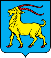 | |
| Municipalities | ||
| Authority control |
|---|