Cerovlje
| Cerovlje | |
|---|---|
| Municipality | |
|
Cerovlje Municipality Općina Cerovlje | |
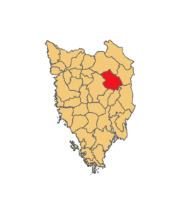 | |
 Cerovlje Location of Cerovlje in Croatia | |
| Coordinates: 45°16′41″N 14°0′36″E / 45.27806°N 14.01000°ECoordinates: 45°16′41″N 14°0′36″E / 45.27806°N 14.01000°E | |
| Country | Croatia |
| County | Istria |
| Area | |
| • Total | 105 km2 (41 sq mi) |
| Population (2011)[1] | |
| • Total | 1,677 |
| • Density | 16/km2 (41/sq mi) |
| Time zone | UTC+1 (CET) |
| • Summer (DST) | UTC+2 (CEST) |
| Postal code | 52402 |
| Area code(s) | 52 |
| Website |
www |
Cerovlje (Italian: Cerreto) is both a village and the surrounding municipality (group of villages gathered together for governmental purposes); it is at the centre of the northern boundary of the Istrian peninsula in Croatia.
Description
Many ancient towns and decayed castles (Belaj, Posert, Paz, Gologorica, Gradinje) can be found in its territory. Almost every town or castle in Cerovlje is on top of a hill, from where they could see enemies from a farther distance. During the Middle Ages (under the reign of the Holy Roman Empire), the people of Cerovlje also built many churches.
Demographics
The total population of Cerovlje is 1,667 (census 2011).[1]
The census of 2011 had recorded the following settlements:[1]
- Belaj, population 16
- Borut, population 213
- Cerovlje, population 241
- Ćusi, population 58
- Draguć, population 68
- Gologorica, population 269
- Gologorički Dol, population 80
- Gradinje, population 43
- Grimalda, population 75
- Korelići, population 53
- Novaki Pazinski, population 200
- Oslići, population 79
- Pagubice, population 127
- Paz, population 72
- Previž, population 83
Municipality Lanišće
| Population number according to the census[2] | |||||||||||||||
|---|---|---|---|---|---|---|---|---|---|---|---|---|---|---|---|
| 1857 | 1869 | 1880 | 1890 | 1900 | 1910 | 1921 | 1931 | 1948 | 1953 | 1961 | 1971 | 1981 | 1991 | 2001 | 2011 |
| 3.585 | 3.707 | 3.954 | 3.993 | 4.185 | 4.378 | 4.405 | 4.780 | 3.834 | 3.607 | 3.049 | 2.485 | 2.024 | 1.815 | 1.745 | 1.677 |
Note: Emerged from old Pazin municipality. From 1857 until 1971 includes part of the data of Pazin.
Lanišće (village)
| Population number according to the census[2] | |||||||||||||||
|---|---|---|---|---|---|---|---|---|---|---|---|---|---|---|---|
| 1857 | 1869 | 1880 | 1890 | 1900 | 1910 | 1921 | 1931 | 1948 | 1953 | 1961 | 1971 | 1981 | 1991 | 2001 | 2011 |
| 131 | 135 | 196 | 228 | 223 | 216 | 0 | 1.090 | 282 | 285 | 303 | 243 | 223 | 203 | 229 | 241 |
Note: In 1921 part of data is contained in Gologorica. In 1931 contains data from villages Gologorica, Gologorički Dol and Previž.
References
- 1 2 3 "Population by Age and Sex, by Settlements, 2011 Census: Cerovlje". Census of Population, Households and Dwellings 2011. Zagreb: Croatian Bureau of Statistics. December 2012.
- 1 2 "Naselja i stanovništvo Republike Hrvatske 1857.-2001" (in Croatian). Retrieved 23 December 2014.
External links
| Wikimedia Commons has media related to Cerovlje. |
- "Cerovlje". Istra County Tourist Association. Retrieved 4 April 2014.
Subdivisions of Istria County | ||
|---|---|---|
| Cities and towns |  | |
| Municipalities | ||
| Authority control |
|---|