Ti'inik
| Ti'inik | |
|---|---|
| Other transcription(s) | |
| • Arabic | تعّنك |
 Ti'inik Location of Ti'inik within Palestine | |
| Coordinates: 32°31′11″N 35°13′16″E / 32.51972°N 35.22111°ECoordinates: 32°31′11″N 35°13′16″E / 32.51972°N 35.22111°E | |
| Palestine grid | 170/214 |
| Governorate | Jenin |
| Government | |
| • Type | Village council |
| Population (2006) | |
| • Jurisdiction | 1,095 |
| Name meaning | sandy[1] |
Ti'inik (Arabic: تعّنك; Hebrew: תיעניכ), also transliterated Ta'anakh, Ti’innik or Taanach, is a Palestinian village in the West Bank, located 13 km Northwest of the city of Jenin in the northern West Bank. The neighbouring Israeli region of Ta'anakh is named after the town.
According to the Palestinian Central Bureau of Statistics, the town had a population of 1,095 inhabitants in mid-year 2006.[2]
Archaeology
Pottery remains from the Roman, Byzantine, and the Middle Ages have been found here.[3]
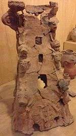
Just to the east of Ti'inik is a 40-metre-high mound which was the site of the biblical city Taanach[4] or Tanach,[5] a Levitical city allocated to the Kohathites.[6][7] Twelve Akkadian cuneiform tablets were found here. Approximately one third of the names on these tablets are of Hurrian origin, indicating a significant northern ethnic presence.[8][9] The main remains visible today are of an 11th-century Abbasid palace.[10]
Ottoman era
Ti'inik, like the rest of Palestine, was incorporated into the Ottoman Empire in 1517, and in the census of 1596, the village appeared as "Ta'inniq”, located in the nahiya of Sara in the liwa of Lajjun. It had a population of 13 households, all Muslim. They paid a taxes on agricultural products, including wheat, barley, summer crops, goats and beehives, in addition to occasional revenues; a total of 7,000 akçe.[11]
In 1838, Ta'annuk was noted as a village in the Jenin district.[12] It only contained a few families, but was said to have been much larger, and to contain ruins.[13]
In 1870 Victor Guérin found that the village consisted of ten houses.[14] He further described it as: 'Once the southern sides and the whole upper plateau of the oblong hill on which the village stands were covered with buildings, as is proved by the innumerable fragments of pottery scattered on the soil, and the materials of every kind which are met with at every step: the larger stones have been carried away elsewhere. Below the village is a little mosque, which passes for an ancient Christian church. It lies, in fact, east and west, and all the stones with which it is built belong to early constructions; some of them are decorated with sculptures. Farther on in the plain are several cisterns cut in the rock, and a well, called Bir Tannuk.'[15]
In 1882 the Palestine Exploration Fund's Survey of Western Palestine described it as "A small village, which stands on the south-east side of the great Tell or mound of the same name at the edge of the plain. It has olives on the south, and wells on the north, and is surrounded with cactus hedges. There is a white dome in the village. The rock on the sides of the Tell is quarried in places, the wells are ancient, and rock-cut tombs occur on the north near the foot of the mound."[16]
British Mandate era
In the 1922 census of Palestine, conducted by the British Mandate authorities, Ti'inik had a population of 65; all Muslims.[17] In the 1931 census it had 64; still all Muslim, in a total of 15 houses.[18]
In the 1945 statistics the population was 100; all Muslims,[19] with 32,263 dunams of land, according to an official land and population survey.[20] 452 dunams were used for plantations and irrigable land, 31,301 dunams for cereals,[21] while a total of 4 dunams were built-up, urban land.[22]
Jordanian era
In the wake of the 1948 Arab–Israeli War, and after the 1949 Armistice Agreements, Ti'inik came under Jordanian rule.
post-1967
After the Six-Day War in 1967, Ti'inik has been under Israeli occupation.
Footnotes
- ↑ Palmer, 1881, p. 153
- ↑ Projected Mid-Year Population for Jenin Governorate by Locality 2004- 2006 Palestinian Central Bureau of Statistics
- ↑ Zertal, 2016, pp. 177-179
- ↑ e.g. New International Version
- ↑ e.g. New King James Version
- ↑ Joshua 21:25
- ↑ David Noel Freedman (2000). "Taanach". Eerdmans Dictionary of the Bible. W.B. Eerdmans. p. 1268. ISBN 978-0-8028-2400-4.
Its identification with modern Tell Ta`annek (171214) is undisputed because of the continuity in the name and because of its location on the southern branch of the Via Maris, next to the pass of Megiddo.
- ↑ Gustavs, A. (1927) Die Personennamen in den Tontafeln von Tell Ta-annek. ZDPV 50, 1-18.
- ↑ Glock, A.E. (1971) A New Ta-annek Tablet. BASOR 204, 17-30.
- ↑ Dave Winter Israel handbook: with the Palestinian Authority areas p644
- ↑ Hütteroth and Abdulfattah, 1977, p. 159
- ↑ Robinson and Smith, 1841, vol 3, 2nd Appendix, p. 131
- ↑ Robinson and Smith, 1841, vol 3, pp. 156, 159
- ↑ Guérin, 1875, p. 226
- ↑ Guérin, 1875, pp. 226 -228; as translated by Conder and Kitchener, 1882, SWP II, p. 68
- ↑ Conder and Kitchener, 1882, SWP II, p. 46
- ↑ Barron, 1923, Table IX, Sub-district of Jenin, p. 30
- ↑ Mills, 1932, p. 71
- ↑ Government of Palestine, Department of Statistics, 1945, p. 17
- ↑ Government of Palestine, Department of Statistics. Village Statistics, April, 1945. Quoted in Hadawi, 1970, p. 55
- ↑ Government of Palestine, Department of Statistics. Village Statistics, April, 1945. Quoted in Hadawi, 1970, p. 99
- ↑ Government of Palestine, Department of Statistics. Village Statistics, April, 1945. Quoted in Hadawi, 1970, p. 149
- ↑ Government of Jordan, Department of Statistics, 1964, p. 25
Bibliography
- Barron, J. B., ed. (1923). Palestine: Report and General Abstracts of the Census of 1922. Government of Palestine.
- Conder, C.R.; Kitchener, H. H. (1882). The Survey of Western Palestine: Memoirs of the Topography, Orography, Hydrography, and Archaeology. 2. London: Committee of the Palestine Exploration Fund.
- Dauphin, Claudine (1998). La Palestine byzantine, Peuplement et Populations. BAR International Series 726 (in French). III : Catalogue. Oxford: Archeopress. ISBN 0-860549-05-4. (p. 743)
- Government of Jordan, Department of Statistics (1964). First Census of Population and Housing. Volume I: Final Tables; General Characteristics of the Population (PDF).
- Government of Palestine, Department of Statistics (1945). Village Statistics, April, 1945.
- Guérin, V. (1875). Description Géographique Historique et Archéologique de la Palestine (in French). 2: Samarie, pt. 2. Paris: L'Imprimerie Nationale.
- Hadawi, S. (1970). Village Statistics of 1945: A Classification of Land and Area ownership in Palestine. Palestine Liberation Organization Research Center.
- Hütteroth, Wolf-Dieter; Abdulfattah, Kamal (1977). Historical Geography of Palestine, Transjordan and Southern Syria in the Late 16th Century. Erlanger Geographische Arbeiten, Sonderband 5. Erlangen, Germany: Vorstand der Fränkischen Geographischen Gesellschaft. ISBN 3-920405-41-2.
- Mills, E., ed. (1932). Census of Palestine 1931. Population of Villages, Towns and Administrative Areas. Jerusalem: Government of Palestine.
- Palmer, E. H. (1881). The Survey of Western Palestine: Arabic and English Name Lists Collected During the Survey by Lieutenants Conder and Kitchener, R. E. Transliterated and Explained by E.H. Palmer. Committee of the Palestine Exploration Fund.
- Robinson, E.; Smith, E. (1841). Biblical Researches in Palestine, Mount Sinai and Arabia Petraea: A Journal of Travels in the year 1838. 3. Boston: Crocker & Brewster.
- Zertal, A. (2016). The Manasseh Hill Country Survey. 3. Boston: BRILL. ISBN 9004312307.
External links
- The Archaeology of Ottoman Ti’innik
- Welcome To Ti'innik
- Survey of Western Palestine, Map 8: IAA, Wikimedia commons
| Cities |  | |
|---|---|---|
| Municipalities |
| |
| Villages |
| |