Thong Pha Phum National Park
| Thong Pha Phum National Park | |
|---|---|
| อุทยานแห่งชาติทองผาภูมิ | |
|
IUCN category II (national park) | |
 | |
 Park location in Thailand | |
| Location | Kanchanaburi Province, Thailand |
| Nearest city | Kanchanaburi |
| Coordinates | 14°41′34″N 98°24′13″E / 14.69278°N 98.40361°ECoordinates: 14°41′34″N 98°24′13″E / 14.69278°N 98.40361°E |
| Area | 1,236 km2 (477 sq mi) |
| Established | 23 December 2009 |
| Governing body | Department of National Parks, Wildlife and Plant Conservation |
Thong Pha Phum National Park (Thai: อุทยานแห่งชาติทองผาภูมิ) is a national park in Kanchanaburi Province, Thailand. The park, located on the border with Myanmar, is part of the Western Forest Complex protected area.
Geography
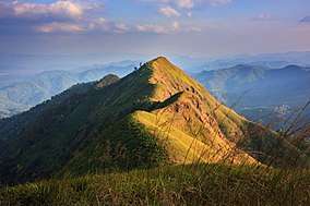
Thong Pha Phum National Park is located about 175 kilometres (100 mi) northwest of Kanchanaburi town and 30 kilometres (20 mi) west of Thong Pha Phum, in Sangkhla Buri and Thong Pha Phum Districts. The park's area is 1,236 square kilometres (477 sq mi). Khao Chang Phueak is the park's highest peak at 1,249 metres (4,098 ft).[1]
History
On 23 December 2009, Thong Pha Phum became Thailand's 114th National Park.[1]
Attractions
The park has numerous waterfalls and caves. Chok Kradin waterfall descends 30 metres (100 ft) over a cliff. Another large waterfall is Khao Yai, with three levels. Other park waterfalls include Dip Yai, Bi Teng and Huai Meuang. Khao Noi cave houses Buddha images. Khao Khat viewpoint offers a panoramic view over the park.[1]
Fauna
Animal species include elephant, tiger, water buffalo, northern red muntjac and civet. Bird life includes hornbills, bulbul and coucal.[1][2]
References
| Wikimedia Commons has media related to Thong Pha Phum National Park. |
- 1 2 3 4 "National Parks in Thailand: Thong Pha Phum National Park" (PDF). Department of National Parks (Thailand). 2015. p. 204. Retrieved 26 June 2017.
- ↑ "Thong Pha Phum National Park". Department of National Parks (Thailand). Archived from the original on 22 May 2013. Retrieved 27 May 2013.