Phu Toei National Park
| Phu Toei National Park | |
|---|---|
| อุทยานแห่งชาติพุเตย | |
|
IUCN category II (national park) | |
 | |
 Location within Thailand | |
| Location | Dan Chang District, Suphan Buri Province, Thailand |
| Coordinates | 14°54′32″N 99°27′36″E / 14.909°N 99.46°ECoordinates: 14°54′32″N 99°27′36″E / 14.909°N 99.46°E[1] |
| Area | 317 km2 (122 sq mi) |
| Established | 1998 |
| Governing body | Department of National Parks, Wildlife and Plant Conservation |
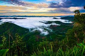
Phu Toei National Park (อุทยานแห่งชาติพุเตย) is a 317 km2 (122 sq mi)[1] national park located in Dan Chang District of Suphan Buri Province, Thailand. It has been a national park since September 30, 1998. On 26 May 1991, Lauda Air Flight 004 crashed over the park after one of the Boeing 767's thrust reversers deployed in mid-air.[2]
The park is visited by about 300 people monthly during the peak of the high season. The Daily Xpress of Singapore states that the park "goes down as one of Thailand's least known and least visited national parks. So much so, that most Suphan Buri folk don't even realise that their province has a national park."[3]
A dominant feature of the park is Khao Thevada (Angel Mountain), a 1,123-metre (3,684 ft) mountain[4] that is the highest in the province. The mountain is on the borders of Kanchanaburi and Uthai Thani provinces.[3]
See also
References
- 1 2 "Phu Toei National Park". protectedplanet.net.
- ↑ "Phu Toei National Park Archived May 22, 2013, at the Wayback Machine.." Department of National Parks, Wildlife and Plant Conservation. Retrieved on July 1, 2011.
- 1 2 "A little-known GEM". Singapore: Daily Xpress (AsiaOne). May 21, 2008. Archived from the original on 2013-01-17. Retrieved July 1, 2011.
- ↑ "National Parks in Thailand: Phu Toei National Park" (PDF). Department of National Parks (Thailand). 2015. pp. 200–201. Retrieved 19 June 2017.
| Wikimedia Commons has media related to Phu Toei National Park. |