Way of the Roses
| Way of the Roses | |
|---|---|
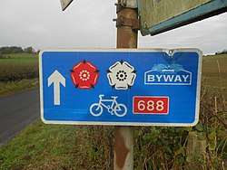 A typical Way of the Roses sign showing the red and white roses, a direction arrow and route number | |
| Established | 2010 |
| Length | 170 mi (274 km) |
| Location | Lancashire & Yorkshire, United Kingdom |
| Designation | NCN routes |
| Trailheads |
Morecambe (west) 54°04′16″N 2°52′34″W / 54.0710°N 2.8760°W Bridlington (east) 54°05′33″N 0°10′38″W / 54.0924°N 0.1772°W |
| Use |
cycling pedestrians |
| Elevation | |
| Highest point | Greenhow, 1,325[1] ft (404 m) |
| Cycling details | |
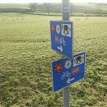
| Waymark |
 |
| Surface | Varies from on-road, to traffic-free tarmac, compacted surface and cinder track |
| Website | Guide to the Way of the Roses |
| Trail map | |
 | |
| Route Map | |||||||||||||||||||||||||||||||||||||||||||||||||||||||||||||||||||||||||||||||||||||||||||||||||||||||||||||||||||||||||||||||||||||||||||||||||||||||||||||||||||||||||||||||||||||||||||||||||||||||||||||||||||||||||||||||||||||||||||||||||||||||||||||||||||||||||||||||||||||||||||||||||||||||||||||||||||||||||||||||||||||||||||||||||||||||||||||||||||||||||||||||
|---|---|---|---|---|---|---|---|---|---|---|---|---|---|---|---|---|---|---|---|---|---|---|---|---|---|---|---|---|---|---|---|---|---|---|---|---|---|---|---|---|---|---|---|---|---|---|---|---|---|---|---|---|---|---|---|---|---|---|---|---|---|---|---|---|---|---|---|---|---|---|---|---|---|---|---|---|---|---|---|---|---|---|---|---|---|---|---|---|---|---|---|---|---|---|---|---|---|---|---|---|---|---|---|---|---|---|---|---|---|---|---|---|---|---|---|---|---|---|---|---|---|---|---|---|---|---|---|---|---|---|---|---|---|---|---|---|---|---|---|---|---|---|---|---|---|---|---|---|---|---|---|---|---|---|---|---|---|---|---|---|---|---|---|---|---|---|---|---|---|---|---|---|---|---|---|---|---|---|---|---|---|---|---|---|---|---|---|---|---|---|---|---|---|---|---|---|---|---|---|---|---|---|---|---|---|---|---|---|---|---|---|---|---|---|---|---|---|---|---|---|---|---|---|---|---|---|---|---|---|---|---|---|---|---|---|---|---|---|---|---|---|---|---|---|---|---|---|---|---|---|---|---|---|---|---|---|---|---|---|---|---|---|---|---|---|---|---|---|---|---|---|---|---|---|---|---|---|---|---|---|---|---|---|---|---|---|---|---|---|---|---|---|---|---|---|---|---|---|---|---|---|---|---|---|---|---|---|---|---|---|---|---|---|---|---|---|---|---|---|---|---|---|---|---|---|---|---|---|---|---|---|---|---|---|---|---|---|---|---|---|---|---|---|---|---|---|---|---|---|---|---|---|---|---|---|---|---|---|---|---|---|---|---|---|---|---|---|
| |||||||||||||||||||||||||||||||||||||||||||||||||||||||||||||||||||||||||||||||||||||||||||||||||||||||||||||||||||||||||||||||||||||||||||||||||||||||||||||||||||||||||||||||||||||||||||||||||||||||||||||||||||||||||||||||||||||||||||||||||||||||||||||||||||||||||||||||||||||||||||||||||||||||||||||||||||||||||||||||||||||||||||||||||||||||||||||||||||||||||||||||
The Way of the Roses is the newest of Great Britain's coast-to-coast, long-distance cycle routes and is based on minor roads, disused railway lines and specially constructed cycle paths. It lies entirely within the counties of Lancashire and Yorkshire, crossing the Yorkshire Dales and the Yorkshire Wolds in the north of England, passing through the historic cities of Lancaster and York and scenic towns and villages including Settle, Pateley Bridge and Ripon.
At 170 miles (270 km) long,[2] the route is designed for the whole range of cyclists, from families to cycling club riders. Although a challenge with some hard climbs—the highest point being over 1,312 feet (400 m) the route is steadily increasing in popularity. The route is fully open and signed.
The route is named after the Wars of the Roses, a fifteenth-century war between the English dynastic families Lancaster and York.[3]
History
The route was developed by Sustrans and part of the National Cycle Network (NCN Route 69) in partnership with various Local Authorities, Lancaster City Council, Cyclists Touring Club, Bridlington Renaissance Partnership and Welcome to Yorkshire amongst others. The route was opened in 2010 running from Morecambe on the west coast of Lancashire to the east coast at Bridlington.[4] A second diversion between Pateley Bridge and York that goes via Harrogate and Knaresborough was opened in 2011.[5] Additionally, there is a section that links Kingston upon Hull to the cycle route that joins/leaves near Pocklington rather than going to/from Bridlington.[6]
Art
A number of public artworks have been commissioned for the route. Matt Baker is currently developing a series of linked artworks at various points along the route. This work has not yet been completed.[7]
Route
The route is well signposted with signs carrying the name of the route or marked with the red and white heraldic roses from which the name of the route is derived.
The route starts in the resort town of Morecambe, Lancashire loosely following the River Lune and the River Wenning into the Pennines at Settle and entering into the stunning scenery of the Yorkshire Dales National Park.[8] From there it makes its steepest climb (eastwards) across the edge of Rye Loaf Hill before descending to Airton. Thence it heads northeast to Grassington before following the River Wharfe for several miles and then turning towards the high point of the route at Greenhow and descending to Pateley Bridge on the River Nidd. Beyond Pateley Bridge the hills are significantly lower and after Ripon (with a short exception of the Yorkshire Wolds) the route is more or less flat, passing through York before finally reaching Bridlington and the North Sea. The route is made up primarily of:
- Minor Roads – quiet, country roads – 90%
- Main Roads – mainly short sections through urban areas – 5%
- Cyclepaths/Off Road – disused railway lines etc.- 5%
The Way Of The Roses is best ridden from West to East to take advantage of the prevailing winds from the West[9] and the more favourable gradients. Tradition dictates that you start the ride by dipping your back wheel in the Irish Sea and only ends when your front wheel gets a dip in the North Sea at the finish. It is typically completed in 3–5 days.[10]
Related NCN Routes
The Way of the Roses makes use of 8 National Cycle Network routes. Starting in Morecambe on Route 69. It transfers to Route 68 at Clapham (54°07′02″N 2°23′30″W / 54.1173°N 2.3918°W), on to Route 688 at Winterburn (54°01′21″N 2°06′09″W / 54.0226°N 2.1025°W), and Route 65 at Linton-on-Ouse (54°02′19″N 1°14′06″W / 54.0387°N 1.2351°W). Through central York (53°57′41″N 1°05′33″W / 53.9614°N 1.0924°W) it follows the short Route 658 before joining Route 66 (53°57′35″N 1°03′04″W / 53.9597°N 1.0511°W). At Pockington (53°55′51″N 0°46′33″W / 53.9309°N 0.7758°W) it takes Route 164 over the Yorkshire Wolds before picking up Route 1 near Hutton Cranswick (53°57′14″N 0°29′53″W / 53.954°N 0.498°W), which it then uses to the finish in Bridlington.[11]
The route links to other parts of the NCN so can be used as part of a longer cycle tour. In addition to the above listed routes the way of the Roses has junctions with Route 700 at Morecambe (54°04′16″N 2°52′34″W / 54.0710°N 2.8760°W), Route 6 at Lancaster (54°03′08″N 2°48′09″W / 54.0522°N 2.8025°W), Route 67 near Fountains Abbey (54°05′29″N 1°34′38″W / 54.0914°N 1.5771°W). and Route 167 at Huggate in the Yorkshire Wolds(53°59′02″N 0°39′50″W / 53.984°N 0.6638°W).
Route maps for The Way Of The Roses and detailed route guides from other publishers are available from Sustrans.[12]
References
- ↑ "Way of the Roses – LDWA Long Distance Paths". www.ldwa.org.uk. Retrieved 1 September 2017.
- ↑ "Way of the Roses". GPS Cycle and Walking Routes. Retrieved 27 July 2017.
- ↑ McFarland, Rob (8 November 2015). "Coast to coast England cycling trip: The Way of the Roses". Newcastle Herald. Retrieved 1 September 2017.
- ↑ "BBC – 'Way of the Roses' coast-to-coast cycle route launched". BBC News. 7 September 2010. Retrieved 1 September 2017.
- ↑ "On your bike coast to coast". The Yorkshire Post. 6 August 2010. Retrieved 1 September 2017.
- ↑ "Way of the Roses" (PDF). bridlingtonrenaissance.com. Retrieved 1 September 2017.
- ↑ "Way of the Roses — Public Art". wayoftheroses.info. Retrieved 1 September 2017.
- ↑ "The Way of the Roses coast to coast ride". The Guardian. 4 May 2012. Retrieved 16 June 2012.
- ↑ "The Way of the Roses, cycle from Lancashire to East Yorkshire". Countryfile.com. 5 January 2012. Retrieved 1 September 2017.
- ↑ Dixe Wills (23 July 2010). "Roller coaster: a cycle trip across northern England". The Guardian. Retrieved 16 June 2012.
- ↑ Way of the Roses Sustrans' Cycle Route Map. Sustrans. 2010. ISBN 1901389839.
- ↑ "Way of the Roses – Map". Sustrans. Retrieved 1 September 2017.
External links
- Official online guide to the Way of the Roses
- Review at the Guardian
- Sustrans. The Way Of The Roses.
Coordinates: 54°05′47″N 1°28′49″W / 54.0964°N 1.4804°W