Templeton Township, Atchison County, Missouri
| Templeton Township | |
|---|---|
| Township | |
 | |
| Coordinates: 40°23′12″N 095°36′10″W / 40.38667°N 95.60278°WCoordinates: 40°23′12″N 095°36′10″W / 40.38667°N 95.60278°W | |
| Country | United States |
| State | Missouri |
| County | Atchison |
| Area | |
| • Total | 25.34 sq mi (65.64 km2) |
| • Land | 24.84 sq mi (64.33 km2) |
| • Water | 0.51 sq mi (1.31 km2) 2.00% |
| Elevation[1] | 889 ft (271 m) |
| Population (2010) | |
| • Total | 79 |
| • Density | 3/sq mi (1.2/km2) |
| FIPS code | 29-72646[2] |
| GNIS feature ID | 0766240 |
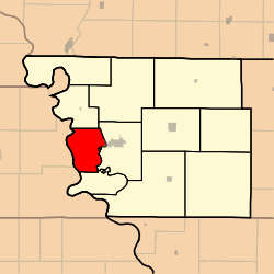
Templeton Township is one of eleven townships in Atchison County, Missouri, United States. As of the 2010 census, its population was 79.[3]
Templeton Township was established in 1870, and named after John W. Templeton, a county official.[4]
Geography
Templeton Township covers an area of 25.3 square miles (65.6 km2) and contains no incorporated settlements.
Nishnabotna Lake is within this township.[5]
Transportation
Templeton Township contains one airport, Rock Port Municipal Airport.
References
- ↑ "US Board on Geographic Names". United States Geological Survey. 2007-10-25. Retrieved 2008-01-31.
- ↑ "American FactFinder". United States Census Bureau. Retrieved 2008-01-31.
- ↑ "Geographic Identifiers: 2010 Demographic Profile Data (G001): Templeton township, Atchison County, Missouri". U.S. Census Bureau, American Factfinder. Retrieved June 25, 2013.
- ↑ "Atchison County Place Names, 1928-1945 (archived)". The State Historical Society of Missouri. Archived from the original on 24 June 2016. Retrieved 30 August 2016.
- ↑ http://mapcarta.com/22458762
External links
Municipalities and communities of Atchison County, Missouri, United States | ||
|---|---|---|
| Cities | 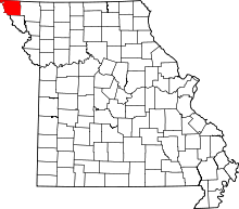 | |
| Village | ||
| Townships | ||
| CDPs | ||
| Unincorporated communities | ||
| Ghost towns | ||
This article is issued from
Wikipedia.
The text is licensed under Creative Commons - Attribution - Sharealike.
Additional terms may apply for the media files.