Clay Township, Atchison County, Missouri
| Clay Township | |
|---|---|
| Township | |
 | |
| Coordinates: 40°25′20″N 095°31′03″W / 40.42222°N 95.51750°WCoordinates: 40°25′20″N 095°31′03″W / 40.42222°N 95.51750°W | |
| Country | United States |
| State | Missouri |
| County | Atchison |
| Area | |
| • Total | 42.03 sq mi (108.85 km2) |
| • Land | 42.01 sq mi (108.80 km2) |
| • Water | 0.02 sq mi (0.06 km2) 0.05% |
| Elevation[1] | 1,047 ft (319 m) |
| Population (2010) | |
| • Total | 1,798 |
| • Density | 43/sq mi (16.5/km2) |
| FIPS code | 29-14284[2] |
| GNIS feature ID | 0766233 |
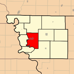
Clay Township is one of eleven townships in Atchison County, Missouri, United States. As of the 2010 census, its population was 1,798.[3]
Clay Township was organized in 1856, and named after Henry Clay of Kentucky.[4]
Geography
Clay Township covers an area of 42.0 square miles (108.9 km2) and contains one incorporated settlement, Rock Port (the county seat). It contains five cemeteries: Bush, Green Hill, Hunter, Millsap and Smith.
The streams of Boney Branch, Turkey Creek and Volger Branch run through this township.
Transportation
Clay Township contains one airport, Luhrs Landing Strip.
References
- ↑ "US Board on Geographic Names". United States Geological Survey. 2007-10-25. Retrieved 2008-01-31.
- ↑ "American FactFinder". United States Census Bureau. Archived from the original on 2013-09-11. Retrieved 2008-01-31.
- ↑ "Geographic Identifiers: 2010 Demographic Profile Data (G001): Clay township, Atchison County, Missouri". U.S. Census Bureau, American Factfinder. Retrieved June 25, 2013.
- ↑ "Atchison County Place Names, 1928-1945 (archived)". The State Historical Society of Missouri. Archived from the original on 24 June 2016. Retrieved 30 August 2016.
External links
Municipalities and communities of Atchison County, Missouri, United States | ||
|---|---|---|
| Cities | 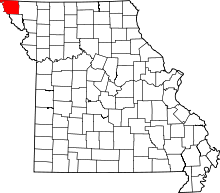 | |
| Village | ||
| Townships | ||
| CDPs | ||
| Unincorporated communities | ||
| Ghost towns | ||
This article is issued from
Wikipedia.
The text is licensed under Creative Commons - Attribution - Sharealike.
Additional terms may apply for the media files.