Blanchard, Missouri
| Blanchard, Missouri | |
|---|---|
| Census-designated place | |
 | |
 Blanchard | |
| Coordinates: 40°34′41″N 95°13′17″W / 40.57806°N 95.22139°WCoordinates: 40°34′41″N 95°13′17″W / 40.57806°N 95.22139°W | |
| Country | United States |
| State | Missouri |
| County | Atchison |
| Area[1] | |
| • Total | 0.53 sq mi (1.37 km2) |
| • Land | 0.53 sq mi (1.37 km2) |
| • Water | 0 sq mi (0 km2) |
| Elevation | 1,020 ft (310 m) |
| Population (2010) | |
| • Total | 22 |
| • Density | 41/sq mi (16.0/km2) |
| Time zone | UTC-6 (Central (CST)) |
| • Summer (DST) | UTC-5 (CDT) |
| Area code(s) | 660 |
| GNIS feature ID | 2587055[2] |
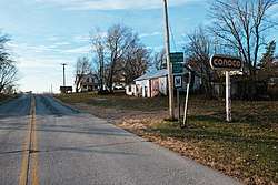
Blanchard is a census-designated place and unincorporated community in Atchison County, Missouri, United States. As of the 2010 census, its population was 22.[3] The community is located on the Iowa border and is adjacent to the city of Blanchard, Iowa.[4] It has sometimes been known as "South Blanchard".[5]
References
- ↑ "US Gazetteer files: 2010, 2000, and 1990". United States Census Bureau. 2011-02-12. Retrieved 2011-04-23.
- ↑ "Blanchard Census Designated Place". Geographic Names Information System. United States Geological Survey.
- ↑ "Geographic Identifiers: 2010 Demographic Profile Data (G001): Blanchard CDP, Missouri". U.S. Census Bureau, American Factfinder. Retrieved June 25, 2013.
- ↑ "South Blanchard (historical)". Geographic Names Information System. United States Geological Survey.
- ↑ "Atchison County Place Names, 1928-1945 (archived)". The State Historical Society of Missouri. Archived from the original on 24 June 2016. Retrieved 30 August 2016.
Municipalities and communities of Atchison County, Missouri, United States | ||
|---|---|---|
| Cities | 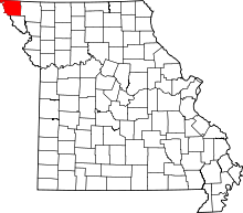 | |
| Village | ||
| Townships | ||
| CDPs | ||
| Unincorporated communities | ||
| Ghost towns | ||
This article is issued from
Wikipedia.
The text is licensed under Creative Commons - Attribution - Sharealike.
Additional terms may apply for the media files.