Polk Township, Atchison County, Missouri
| Polk Township | |
|---|---|
| Township | |
 | |
| Coordinates: 40°31′16″N 095°30′38″W / 40.52111°N 95.51056°WCoordinates: 40°31′16″N 095°30′38″W / 40.52111°N 95.51056°W | |
| Country | United States |
| State | Missouri |
| County | Atchison |
| Area | |
| • Total | 62.32 sq mi (161.41 km2) |
| • Land | 62.32 sq mi (161.41 km2) |
| • Water | 0 sq mi (0 km2) 0% |
| Elevation[1] | 994 ft (303 m) |
| Population (2010) | |
| • Total | 226 |
| • Density | 4/sq mi (1.4/km2) |
| FIPS code | 29-58700[2] |
| GNIS feature ID | 0766238 |
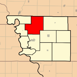
Polk Township is one of eleven townships in Atchison County, Missouri, United States. As of the 2010 census, its population was 226.[3]
Polk Township was established in 1845, and named after President James K. Polk.[4]
Geography
Polk Township covers an area of and contains no incorporated settlements. It contains six cemeteries: High Creek, Linden, St. John's Lutheran, Grange Hall, Noblitt-gibson, and Steiner.
The streams of McElroy Creek, High Creek, West High Creek, and Hall Branch run through this township.
References
- ↑ "US Board on Geographic Names". United States Geological Survey. 2007-10-25. Retrieved 2008-01-31.
- ↑ "American FactFinder". United States Census Bureau. Retrieved 2008-01-31.
- ↑ "Geographic Identifiers: 2010 Demographic Profile Data (G001): Polk township, Atchison County, Missouri". U.S. Census Bureau, American Factfinder. Retrieved June 25, 2013.
- ↑ "Atchison County Place Names, 1928-1945 (archived)". The State Historical Society of Missouri. Archived from the original on 24 June 2016. Retrieved 30 August 2016.
External links
Municipalities and communities of Atchison County, Missouri, United States | ||
|---|---|---|
| Cities | 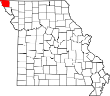 | |
| Village | ||
| Townships | ||
| CDPs | ||
| Unincorporated communities | ||
| Ghost towns | ||
This article is issued from
Wikipedia.
The text is licensed under Creative Commons - Attribution - Sharealike.
Additional terms may apply for the media files.