Temenggor Lake
| Temenggor Lake Tasik Temenggor | |
|---|---|
 | |
| Location | Peninsula Malaysia |
| Coordinates | 5°19′N 101°12′E / 5.31°N 101.20°ECoordinates: 5°19′N 101°12′E / 5.31°N 101.20°E |
| Type | reservoir |
| Basin countries | Malaysia |
| Islands | Banding Island |
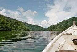
Temenggor Lake (Malay: Tasik Temenggor) is a lake in Hulu Perak District, Perak, Malaysia. It is the second largest lake in Peninsula Malaysia after Kenyir Lake in Terengganu. This man-made lake is located south of 1,533 m high Ulu Titi Basah peak,.[1] It was created after the construction of Temenggor Dam to generate electric power. The lake is located about 45 km from the Hulu Perak district capital, Gerik. There is a man-made island, Banding Island (Pulau Banding)[2] and Lake Temenggor Bridge on the East-West Highway which crosses the lake.

Notable features
- Belum Rainforest Resort
- Belum forest
- Temenggor Lake Bridge
- Malaysian Public Works Department (JKR) East-West Highway Monument
- Orang Asli village
See also
References
- ↑ "Gunong Ulu Titi Basah". Geographic.org. 1994-04-06. Retrieved 2013-04-30.
- ↑ "Pulau Banding, Temenggor lake". Perak.info. 2012-08-24. Archived from the original on 2007-11-02. Retrieved 2013-04-30.
External links
| Wikimedia Commons has media related to Temenggor Lake. |
| NCER Perlis |
|
|---|---|
| NCER Kedah | |
| NCER Penang |
|
| NCER Perak | |
This article is issued from
Wikipedia.
The text is licensed under Creative Commons - Attribution - Sharealike.
Additional terms may apply for the media files.