Kangar
| Kangar, Perlis | |
|---|---|
| State Capital | |
 | |
 Kangar Location in Malaysia | |
| Coordinates: 6°26′N 100°12′E / 6.433°N 100.200°E | |
| Country |
|
| State |
|
| Established | 1897 |
| Granted municipality status | 1 Januari 1980 |
| Population (2005) | |
| • Total | 48,898 |
| Time zone | UTC+8 (MST) |
| • Summer (DST) | Not observed |
| Website |
mpkangar |
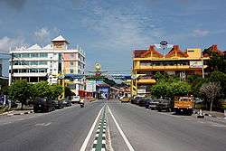
Kangar is the state capital of Perlis, Malaysia. It has a population of 48,898 and an area of 2,619.4 ha. It is located in the northernmost point of Peninsular Malaysia and is situated by the Perlis River. The centre of Kangar is Sena Province. The town is the smallest state capital in Malaysia and its inhabitants are mostly farmers and civil servants.
It is believed that the name Kangar was derived from a species of hawk named Kangkok or Spizaetus Limnaetu.
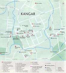
Kangar Map
Places of interest
Downtown Kangar is a mixture of old and new shophouses, and has an elegant colonial State Secretariat Building and clocktower from the 1930s. Other major landmarks are:
- Bangunan KWSP, one of the highest point in Kangar
- Dato' Wan Ahmad's House
- Kubu Hill Recreational Park
- Malay World Weaponry Museum
- Medan Mountain
- Perlis Craft Cultural Complex
- State Museum and Heritage Hall
- Alwi Mosque, the former state mosque built in 1910
- Tuanku Syed Putra Stadium
- Kuala Perlis Bus Terminal and Kuala Perlis Ferry Service
- Dark Cave (Gua Kelam) of Kaki Bukit
- Snake Farm of Sungai Batu Pahat
- Bukit Ayer Recreational Park
- Wang Kelian - Next to Thai border
- Padang Besar Shopping Arcade - Duty Free Zone
- Royal Palace of Arau
- Fish Grill Food Court of Kuala Perlis
- Mini Putrajaya - State Assembly Building
- Gua Cenderawasih Park - Look out point
Notable natives
- Queenzy Cheng, singer and actress
External links
| Wikimedia Commons has media related to Kangar. |
Capital: Kangar | |||||
| Topics |
| ||||
| Society |
| ||||
| Administrative divisions |
| ||||
| |||||
| NCER Perlis |
|
|---|---|
| NCER Kedah | |
| NCER Penang |
|
| NCER Perak | |
Coordinates: 6°26′N 100°12′E / 6.433°N 100.200°E
This article is issued from
Wikipedia.
The text is licensed under Creative Commons - Attribution - Sharealike.
Additional terms may apply for the media files.