Tejay, Kentucky
| Tejay | |
|---|---|
| Unincorporated community | |
 Tejay Location within the state of Kentucky  Tejay Tejay (the US) | |
| Coordinates: 36°45′49″N 83°33′44″W / 36.76361°N 83.56222°WCoordinates: 36°45′49″N 83°33′44″W / 36.76361°N 83.56222°W | |
| Country | United States |
| State | Kentucky |
| County | Bell |
| Elevation | 1,063 ft (324 m) |
| Time zone | UTC-5 (Eastern (EST)) |
| • Summer (DST) | UTC-4 (EDT) |
| GNIS feature ID | 509194[1] |
Tejay is an unincorporated community located in Bell County, Kentucky, United States. It was named for Thomas Jefferson Asher (1848-1935), landowner and founder.[2]
References
- ↑ U.S. Geological Survey Geographic Names Information System: Tejay, Kentucky
- ↑ Rennick, Robert M. (2013). Kentucky Place Names. University Press of Kentucky. ISBN 9780813144016.
Municipalities and communities of Bell County, Kentucky, United States | ||
|---|---|---|
| Cities | 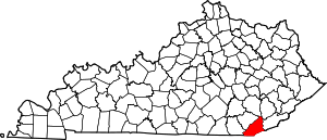 | |
| Unincorporated communities |
| |
| Ghost towns | ||
| Footnotes | ‡This populated place also has portions in an adjacent county or counties | |
This article is issued from
Wikipedia.
The text is licensed under Creative Commons - Attribution - Sharealike.
Additional terms may apply for the media files.