Calvin, Kentucky
| Calvin, Kentucky | |
|---|---|
| Unincorporated community | |
 Calvin  Calvin | |
| Coordinates: 36°43′20″N 83°37′20″W / 36.72222°N 83.62222°WCoordinates: 36°43′20″N 83°37′20″W / 36.72222°N 83.62222°W | |
| Country | United States |
| State | Kentucky |
| County | Bell |
| Elevation | 1,079 ft (329 m) |
| Time zone | UTC-5 (Eastern (EST)) |
| • Summer (DST) | UTC-4 (EDT) |
| ZIP code | 40813 |
| Area code(s) | 606 |
| GNIS feature ID | 488650[1] |
Calvin is an unincorporated community in Bell County, Kentucky, United States.[1] The community is located along U.S. Route 119 and the Cumberland River 4.9 miles (7.9 km) southeast of Pineville. The area on the south side of the river is also known as Page, which was the name of the Louisville_and_Nashville_Railroad station in the community.[2] Calvin has a post office with ZIP code 40813, which opened on April 3, 1908.[3][4]
References
- 1 2 "Calvin". Geographic Names Information System. United States Geological Survey.
- ↑ "Kentucky Hometown Locator". Retrieved June 6, 2018.
- ↑ United States Postal Service. "USPS - Look Up a ZIP Code". Retrieved April 9, 2017.
- ↑ "Postmaster Finder - Post Offices by ZIP Code". United States Postal Service. Retrieved April 9, 2017.
Municipalities and communities of Bell County, Kentucky, United States | ||
|---|---|---|
| Cities | 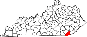 | |
| Unincorporated communities |
| |
| Ghost towns | ||
| Footnotes | ‡This populated place also has portions in an adjacent county or counties | |
This article is issued from
Wikipedia.
The text is licensed under Creative Commons - Attribution - Sharealike.
Additional terms may apply for the media files.