Stoney Fork, Kentucky
| Stoney Fork, Kentucky | |
|---|---|
| Unincorporated community | |
 Stoney Fork, Kentucky | |
| Coordinates: 36°49′56″N 83°32′05″W / 36.83222°N 83.53472°WCoordinates: 36°49′56″N 83°32′05″W / 36.83222°N 83.53472°W | |
| Country | United States |
| State | Kentucky |
| County | Bell |
| Elevation | 1,112 ft (339 m) |
| Time zone | UTC-5 (Eastern (EST)) |
| • Summer (DST) | UTC-4 (EDT) |
| ZIP code | 40988 |
| Area code(s) | 606 |
| GNIS feature ID | 504491[1] |
Stoney Fork is an unincorporated community in Bell County, Kentucky, United States. Stoney Fork is located on Kentucky Route 221 10.1 miles (16.3 km) east-northeast of Pineville.[2] Stoney Fork has a post office with ZIP code 40988, which opened on November 20, 1946.[3][4]
References
- ↑ "Stoney Fork". Geographic Names Information System. United States Geological Survey.
- ↑ State Primary Road System: Bell County (PDF) (Map). Kentucky Transportation Cabinet. 2012. Retrieved February 23, 2013.
- ↑ United States Postal Service (2012). "USPS - Look Up a ZIP Code". Retrieved 2012-02-15.
- ↑ "Postmaster Finder - Post Offices by ZIP Code". United States Postal Service. Retrieved February 23, 2013.
Municipalities and communities of Bell County, Kentucky, United States | ||
|---|---|---|
| Cities | 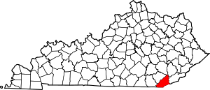 | |
| Unincorporated communities |
| |
| Ghost towns | ||
| Footnotes | ‡This populated place also has portions in an adjacent county or counties | |
This article is issued from
Wikipedia.
The text is licensed under Creative Commons - Attribution - Sharealike.
Additional terms may apply for the media files.