Kingston Railway Bridge
| Kingston Railway Bridge | |
|---|---|
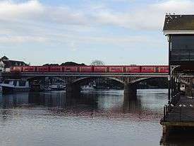 South West Trains service crossing Kingston Railway Bridge | |
| Coordinates | 51°24′48.66″N 0°18′30.49″W / 51.4135167°N 0.3084694°W |
| Carries | Kingston-Richmond loop line |
| Crosses | River Thames |
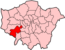
| Locale | Kingston upon Thames |
| Characteristics | |
| Material | Steel |
| Height | 22 feet 4 inches (6.81 m)[1] |
| Longest span | 22 feet 11 inches (6.99 m) |
| No. of spans | 5 |
| Piers in water | 2 |
| History | |
| Designer | J W Jacomb Hood |
| Opened | 1863 |
Kingston Railway Bridge in Kingston upon Thames, London, crosses the River Thames on the reach above Teddington Lock. It carries the entirely passenger-service Kingston Loop Line from London terminus, Waterloo, where the majority of services begin and end and which line includes a maintenance depot. The loop diverges from main lines at New Malden and Richmond. East and west of the bridge along the line are Kingston and Hampton Wick stations. The loop returns to the south bank of its terminus via Richmond Railway Bridge. The loop feeds a branch line, a further incentive for the 1863 construction of the bridge, Shepperton Branch Line.
History
- First Kingston Railway Bridge and its 1907-built replacement
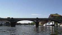
The present bridge was designed by J W Jacomb Hood and built in 1907, replacing a cast-iron bridge designed by J E Errington,[2] first discussed in 1860, completed in 1863.[3]
- Design specifications
The bridge has five arches: three span the Thames; two span dry land, which on the Kingston bank includes a road. The bridge has elevated track approaches varying from on viaduct to on embankment, which navigate curves and fly over an urban grid of roads.
- Former industrial surroundings
Twin power stations were close to the bridge on the Kingston bank from 1893 to 1959 as to one and from 1948 to 1980 as to the later. Being close to the Thames, coal came up river by barge, and ash was sent away the same way.[4] The barge dock was constructed at Kingston Railway Bridge close to the present the upstream entrance to Canbury Gardens. Much of these sites has been landscaped for public park use and accommodates high-specification 21st century mid- and high-rise apartments.[5]
Operational use
In original and privatized railways it carries the South Western compass sector operator's suburban Kingston Loop commencing from its sole London terminus: Waterloo. The loop diverges from main lines at New Malden and Richmond. Within 400 m along the line are Kingston and Hampton Wick stations, dependent on direction. The loop returns to the south bank of its terminus via Richmond Railway Bridge on the combined, major Windsor and Reading (from Waterloo) line. The loop feeds a branch line, the Shepperton Branch Line.
- Complimentary uses
When part of the Kingston Loop is unable to operate, the bridge enables continued passenger services, typically using the capacity of bay platform 1 at Kingston railway station, the only example on the loop. The related branch line, the Shepperton Branch Line is approximately equidistant between the two Thames bridges and the capacity of a bay platform means various service patterns have been used since the bridge was built. Present use of both lines is entirely for stopping services, save for when either main line is diverted, more typically the Windsor and Reading lines which must be diverted via Kingston or via Hounslow when the busiest stretches of that line are being repaired. The loop has Strawberry Hill maintenance depot which can accommodate a few regular trains.
See also
References
- ↑ River Thames Alliance. Bridge heights on the River Thames.
- ↑ Malcolm Tucker (1983). "Thames Crossings" in Bridget Cherry and Nikolaus Pevsner The Buildings of England – London 2: South. London: Penguin Books. p. 716. ISBN 0 14 0710 47 7.
- ↑ Fred S Hacker (1968) [1920]. The Thames Highway: Volume II - Locks and Weirs. David & Charles.
- ↑ Greater London Industrial Archaeology Society
- ↑ Thames Landscape Strategy Archived 1 October 2008 at the Wayback Machine.
| Next crossing upstream | River Thames | Next crossing downstream |
| Kingston Bridge (road) | Kingston Railway Bridge | Teddington Lock Footbridge (pedestrian) |
Coordinates: 51°24′48.6″N 0°18′30.4″W / 51.413500°N 0.308444°W