Te Urewera
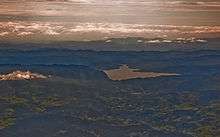
Te Urewera is an area of mostly forested, sparsely populated rugged hill country in the North Island of New Zealand, much of it in the northern Hawke's Bay Region, and some in the eastern Bay of Plenty Region. Much of it is in the Huiarau, Ikawhenua, and Maungapohatu ranges,[1] and there are also lowland areas in the north.[2] The Waikaremoana and Waikareiti lakes lie in the south-eastern part.
Settlements include Ruatahuna and Ruatoki. The area is isolated, with State Highway 38 being the only major arterial road crossing it, running from Waiotapu near Rotorua via Murupara to Wairoa.
It is the historical home of Tūhoe, a Māori iwi (tribe) known for their stance on Māori sovereignty. Because of its isolation and dense forest, Te Urewera remained largely untouched by British colonists until the early 20th century; in the 1880s it was still in effect under Māori control. Te Kooti, the Māori leader, found refuge there from his pursuers among Tuhoe, with whom he formed an alliance. Like the King Country at the time, few Pākehā were prepared to risk entering Te Urewera.[3] In the early 20th century Rua Kenana Hepetipa formed a religious community at Maungapōhatu.
The name Te Urewera is a Māori phrase meaning "The Burnt Penis".[4]
A large part, but by no means all, of the area has a protected status. Te Urewera National Park was established in 1954 and disestablished in 2014, when it was replaced by a new legal entity, simply called Te Urewera.[5] Te Urewera has legal personhood, and owns itself.[6] All North Island native forest bird species, except for the weka, live in the area.[7] The crown fern (Blechnum discolor) is a widespread understory plant.[8]
See also
References
- ↑ McLintock, A.H., ed. (1966). "Urewera". An Encyclopaedia of New Zealand.
- ↑ McKinnon, Malcolm (23 March 2015). "Bay of Plenty places – Urewera lowland settlements". Te Ara – the Encyclopedia of New Zealand.
- ↑ King, Michael (2003). The Penguin History of New Zealand. Penguin Books. ISBN 0-14-301867-1.
- ↑ Binney, Judith (2009). "1". Encircled lands : Te Urewera, 1820–1921. Wellington, N.Z.: Bridget Williams Books. p. 21. ISBN 9781877242441. Retrieved 22 June 2018.
Tūhoe are guardians of the lands they named ‘Te Urewera’, the Burnt Penis. Its fearsome name depicts the fate of Mura-kareke, a son of Tuhoe-potiki, the eponymous ancestor. One version narrates that Mura-kareke chose this death in protest at his sons’ treatment of their youngest brother, his ‘favourite’ child. A different and grimmer version tells that Mura-kareke burnt the severed penis of his younger brother, Mura-anini, in a cooking fire. This was his revenge for Mura-anini’s adultery with Mura-kareke’s wife. Both versions – one stoic, one savagely vengeful – recall family lines in conflict.
- ↑ Ruru, Jacinta (October 2014). "Tūhoe-Crown settlement – Te Urewera Act 2014". Māori Law Review: 16–21. Retrieved 13 December 2015.
- ↑ Te Urewera Act 2014, ss 11–12.
- ↑ "Te Urewera National Park". Department of Conservation. Retrieved 26 March 2012.
- ↑ Hogan, C. Michael. "Crown Fern Blechnum discolor". iGoTerra. Retrieved 13 October 2014.