Tauthali
| Tauthali तौथली hajipur | |
|---|---|
| Small city | |
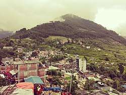 Shikharchuli Heights | |
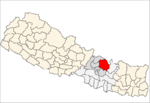
 Tauthali Location in Nepal | |
| Coordinates: 27°44′N 85°55′E / 27.73°N 85.91°ECoordinates: 27°44′N 85°55′E / 27.73°N 85.91°E | |
| Country |
|
| Zone | Bagmati Zone |
| District | Sindhupalchok District |
| Population (2013) | |
| • Total | 3,886 |
| • Religions | Hindu especially newar community |
| Time zone | UTC+5:45 (Nepal Time) |
Tauthali Hajipur is a village in Sindhupalchok District in the Bagmati Zone of central Nepal. Tauthali is 110 km to from Katmandu. In the 2013 Nepal census it had a population of 3,886 in 670 houses.[1] After the devastating earthquake of 2072 almost every house was destroyed including religious sites such as Tripura Sundari Mai. The population grew to around 7000. The villagers started building concrete houses with the help of the government earthquake fund.
Attractions
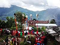
lingha nach
- Newari culture is celebrated on festive occasions, especially the curd festival, like holi with curd.
- Trekking route from Kharidhungha to Tauthali covers around 10km.
- View of Honey hill (Mahabhir Jarna) waterfall
- One of the country's biggest ropeways
- View of mountains like Ganesh and Jugal
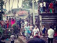
playing curd (dahi jatra)
References
- ↑ "Nepal Census 2001". Nepal's Village Development Committees. Digital Himalaya. Retrieved 2008-08-24.
External links
This article is issued from
Wikipedia.
The text is licensed under Creative Commons - Attribution - Sharealike.
Additional terms may apply for the media files.