Tatakoto Airport
| Tatakoto Airport Aérodrome de Tatakoto | |||||||||||
|---|---|---|---|---|---|---|---|---|---|---|---|
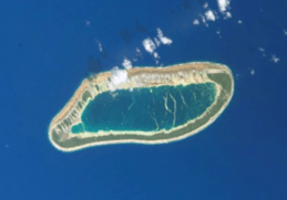 NASA satellite image of Tatakoto | |||||||||||
| Summary | |||||||||||
| Airport type | Public | ||||||||||
| Operator | DSEAC Polynésie Française | ||||||||||
| Serves | Tatakoto, Tuamotu, French Polynesia | ||||||||||
| Elevation AMSL | 3 m / 10 ft | ||||||||||
| Coordinates | 17°21′19″S 138°26′42″W / 17.35528°S 138.44500°WCoordinates: 17°21′19″S 138°26′42″W / 17.35528°S 138.44500°W | ||||||||||
| Map | |||||||||||
 TKV Location of the airport in French Polynesia | |||||||||||
| Runways | |||||||||||
| |||||||||||
|
Source: French AIP.[1] | |||||||||||
Tatakoto Airport (IATA: TKV, ICAO: NTGO) is an airport serving the village of Tumukuru, located on the island of Tatakoto, in the Tuamotu group of atolls in French Polynesia, 1,180 kilometres (730 mi) from Tahiti.
Airlines and destinations
Passenger
| Airlines | Destinations |
|---|---|
| Air Tahiti | Nukutavake, Papeete, Pukarua, Vahitahi |
References
- ↑ NTGO – Fangatau. AIP from French Service d'information aéronautique, effective 11 October 2018.
External links
Tuamotus Gambiers | Islands/Atolls | ||
|---|---|---|---|
| Island groups | |||
This article is issued from
Wikipedia.
The text is licensed under Creative Commons - Attribution - Sharealike.
Additional terms may apply for the media files.