Pukarua Airport
| Pukarua Airport Aérodrome de Pukarua | |||||||||||
|---|---|---|---|---|---|---|---|---|---|---|---|
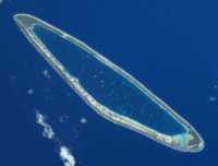 NASA picture of Pukarua Atoll | |||||||||||
| Summary | |||||||||||
| Airport type | Public | ||||||||||
| Operator | DSEAC Polynésie Française | ||||||||||
| Serves | Pukarua | ||||||||||
| Location | Pukarua, Tuamotu, French Polynesia | ||||||||||
| Elevation AMSL | 5 ft / 2 m | ||||||||||
| Coordinates | 18°17′44″S 137°01′01″W / 18.29556°S 137.01694°WCoordinates: 18°17′44″S 137°01′01″W / 18.29556°S 137.01694°W | ||||||||||
| Map | |||||||||||
 PUK Location of the airport in French Polynesia | |||||||||||
| Runways | |||||||||||
| |||||||||||
Pukarua Airport (IATA: PUK, ICAO: NTGQ) is serving the village of Marautagaroa, located on the Pukarua atoll, in the Tuamotu group of atolls in French Polynesia, at 1,125 kilometres (699 mi) from Tahiti.
Airlines and destinations
Passenger
| Airlines | Destinations |
|---|---|
| Air Tahiti | Reao, Tatakoto |
References
- ↑ Airport information for NTGQ at World Aero Data. Data current as of October 2006.Source: DAFIF.
- ↑ NTGQ – Pukarua. AIP from French Service d'information aéronautique, effective 11 October 2018.
External links
Tuamotus Gambiers | Islands/Atolls | ||
|---|---|---|---|
| Island groups | |||
This article is issued from
Wikipedia.
The text is licensed under Creative Commons - Attribution - Sharealike.
Additional terms may apply for the media files.