Vahitahi Airport
| Vahitahi Airport Aérodrome de Vahitahi | |||||||||||
|---|---|---|---|---|---|---|---|---|---|---|---|
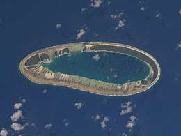 NASA satellite image of Vahitahi | |||||||||||
| Summary | |||||||||||
| Airport type | Public | ||||||||||
| Operator | DSEAC Polynésie Française | ||||||||||
| Serves | Vahitahi, Tuamotu, French Polynesia | ||||||||||
| Elevation AMSL | 3 m / 10 ft | ||||||||||
| Coordinates | 18°46′48″S 138°51′11″W / 18.78000°S 138.85306°WCoordinates: 18°46′48″S 138°51′11″W / 18.78000°S 138.85306°W | ||||||||||
| Map | |||||||||||
 VHZ Location of the airport in French Polynesia | |||||||||||
| Runways | |||||||||||
| |||||||||||
Vahitahi Airport (IATA: VHZ, ICAO: NTUV) is an airport that serves the village of Mohitu, located on the Vahitahi atoll, in the Tuamotu group of atolls in French Polynesia, 960 kilometres (600 mi) from Tahiti.
Vahitahi atoll Airport was inaugurated in 1978.
Airlines and destinations
Passenger
| Airlines | Destinations |
|---|---|
| Air Tahiti | Hao, Tatakoto |
References
- ↑ NTUV – Vahitahi. AIP from French Service d'information aéronautique, effective 11 October 2018.
- ↑ Airport information for NTUV at Great Circle Mapper.
- ↑ Airport information for Vahitahi Airport at Search (for) Travel website.
External links
Tuamotus Gambiers | Islands/Atolls | ||
|---|---|---|---|
| Island groups | |||
This article is issued from
Wikipedia.
The text is licensed under Creative Commons - Attribution - Sharealike.
Additional terms may apply for the media files.