Toussidé
| Toussidé | |
|---|---|
 | |
| Highest point | |
| Elevation | 3,265 m (10,712 ft) |
| Prominence | 1,593 m (5,226 ft) [1] |
| Listing | Ultra |
| Coordinates | 21°02′24″N 16°28′12″E / 21.04000°N 16.47000°ECoordinates: 21°02′24″N 16°28′12″E / 21.04000°N 16.47000°E [1] |
| Geography | |
 Toussidé Location in Chad | |
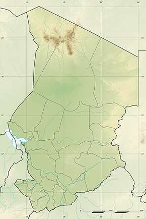
| Location | Tibesti Region, Chad |
| Parent range | Tibesti Mountains |
| Geology | |
| Mountain type | Stratovolcano |
| Last eruption | unknown |
Toussidé (also known as Tarso Toussidé) is a potentially active volcano in Chad. It has an elevation of 3,315 m (10,876 ft) above sea level.[2] Toussidé is one of the volcanoes that make up the Tibesti Mountains, and in its neighbourhood lie the large Yirrigué caldera and the smaller Trou au Natron and Doon Kidimi craters. Toussidé is the source of a number of lava flows, which have flowed westward away from Toussidé and east into the Yirrigué caldera.
Trou au Natron, the depression southeast of the volcano measures approximately 8 by 6 kilometres (5.0 mi × 3.7 mi) diameter and 700–1,000 metres (2,300–3,300 ft) in depth. During the last glacial maximum or the early-middle Holocene, it was filled with a lake. A number of volcanic cones have developed within Trou au Natron. Fumarolic activity on the peak of Toussidé and geothermal manifestations within Trou au Natron are the last signs of volcanic activity at Toussidé.
Names
Toussidé is also known as Tarso Toussidé.[3] "Trou au Natron" refers to the springs which have deposited white trona in the caldera.[4] "Toussidé" translates as "Which killed the local people (Tou) with fire".[5]
Geography and geomorphology
Regional
Toussidé is part of the western Tibesti[6] mountains in Chad, Africa.[7] The Tibesti mountains reach elevations of 3 kilometres (1.9 mi) and are surrounded by the Sahara.[8] The towns of Bardai and Zouar lie east-northeast and south of Toussidé, respectively.[4]
Another volcano in Tibesti is Emi Koussi,[4] which is the highest mountain of the Tibesti and of the entire Sahara region.[6] The volcano Tarso Toh lies northwest of Toussidé,[9] the Botoum and Botoudoma/Petit Botoum rhyolite extrusions are located 10 kilometres (6.2 mi) south of Trou au Natron.[10] The origin of volcanism in Tibesti is unclear; both a hotspot-related mechanism and tectonic effects of the collision between the African Plate and the Eurasian Plate have been proposed.[11]
Local
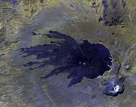
Toussidé is a symmetrical[12] stratovolcano,[7] with 3,265 metres (10,712 ft) height the second highest peak in Tibesti[4] and the highest peak in the western Tibesti mountains.[13] In the past it was considered to be lower, only 2,500 metres (8,200 ft).[14] It rises 1,000 metres (3,300 ft) above the surrounding landscape and covers a base of 8 by 9 kilometres (5.0 mi × 5.6 mi),[13][15] dominating the surroundings.[14] The summit cone is formed by lapilli, pyroclastics and scoria,[16] and has a white and a black half;[17] some areas are white from fumarolic alteration.[3] Lava flows emanate from Toussidé in a radial pattern[18] and reach lengths of 25 kilometres (16 mi), covering an area of 200 square kilometres (77 sq mi).[16] These flows descended valleys towards the west[19] and may have buried an older volcanic edifice of Toussidé.[20] The flows have a ropy appearance with a diverse surface texture, including bubbly, glassy and porphyric textures,[16] which are very fresh and free of erosion.[13] The surface of the flows is rough and can be a problem to climbers.[18][21]
Toussidé itself lies in part within an even larger caldera, the 14 by 13 kilometres (8.7 mi × 8.1 mi) "pre-Toussidé" (also known as "Yirrigué"[22]) caldera which is in part filled by the lava flows from Toussidé and eruption products from more recent explosion craters,[23] as well as debris that fell from the steep caldera margin.[24] Toussidé is located on its western side,[3] and the smaller Trou au Natron caldera cuts into the flanks of Yirrigué.[25] Yirrigué contains a small cinder cone and an associated 1 kilometre (0.62 mi) long lava flow,[26] as well as an alluvial plain.[24] The "Yirrigué" caldera is part of a large rhyolitic shield-shaped volcano[27] that developed on top of a tectonic horst, which in turn may have been formed by intrusion of magmas.[28] The ignimbrites have buried older terrain and filled valleys.[19]
Southeast of Toussidé lies the 8 by 6 kilometres (5.0 mi × 3.7 mi) wide caldera Trou au Natron (also known as Doon[20] or Doon Orei[29]),[4] whose rim reaches heights of 700–1,000 metres (2,300–3,300 ft), cut into sequences of lavas[23] and older volcanic cones.[30] In places it is almost vertical.[31] Inside of Trou au Natron are several recent basaltic volcanic cones,[4] the most remarkable of which is the 75 metres (246 ft) high Moussosomi, which has erupted a lava flow.[30] Three of these cones are deeply eroded.[25] Cones are also located outside of the Trou au Natron and their eruption products have in part flowed into the crater.[31] Like Toussidé, the position of Trou au Natron appears to be controlled by the ring fault of the "pre-Toussidé" caldera.[20] A salty swamp lies within Trou au Natron,[32] whose floor is in part covered by evaporites,[19] mainly sodium sulfate.[33]
Another 1,500 metres (4,900 ft) wide and 300 metres (980 ft) deep crater, Doon Kidimi (also known as Petit Trou[20] or Doon Kinimi[29]), lies northeast of Trou au Natron;[15][18] it is among the freshest volcanic features in the region.[32] Additional volcanoes in the neighbourhood are Ehi Timi and Ehi Sosso,[3] the former of which features lava domes. The river Enneri Oudingueur originates closely in the area and becomes a tributary of the Enneri Bardagué,[19] which drains the Tibesti northward.[34]
_ASTER.jpg) Trou au Natron (centre down) and Doon Kidimi (upper right corner)
Trou au Natron (centre down) and Doon Kidimi (upper right corner) Trou au Natron seen from northeast; Toussidé lava flows upper right corner and Doon Kidimi lower right corner
Paleolake
Trou Au Natron was once filled by a lake during the last glacial maximum.[4] Fed by meltwater from snow, such a lake persisted for several thousands of years. Aside from a lake level drop between 14,900 - 14,600 years before present[35]), the lake persisted[36] until about 12,400 years before present.[37] Later analysis suggested that there was no late Pleistocene lake stage and that Trou au Natron was filled with water between 8,645 calibrated radiocarbon years ago to about 4,425 calibrated radiocarbon years ago, thus at the same time as lakes in the lowland.[38] Charophyte algae (such as Chara globularis and Chara vulgaris[39]), diatoms, gastropods,[4] golden algae, sponges[38] and stromatoliths lived in the lake.[37] Ferns and mosses colonized the margins of the crater.[36]
The lake reached maximum depths of at a minimum 300–350 metres (980–1,150 ft)[4], at least once reaching 500 metres (1,600 ft),[36] and its waters were fresh.[39] Such a large size, relative to its catchment, has raised the question of where this water came from.[40] The formation of such a lake during the glacial maximum was probably dependent on orographic precipitation transported by the subtropical jet stream.[35]
Geology
The Tibesti mountains are part of a volcanic province that reaches from Libya into Chad and which in total covers a surface area of about 100,000 square kilometres (39,000 sq mi).[41] The Tibesti Mountains have been volcanically active since the late Cenozoic, with one old volcanic unit being dated to 17 million years ago.[7] While all the higher peaks are volcanoes, not all of Tibesti is formed by volcanic material; the volcanoes have developed on top of a basement uplift.[41]
The terrain beneath Toussidé is formed by Precambrian schists and sandstones, including the Nubian Sandstone. A thick layer of ash has covered much of the terrain and with the exception of the younger volcanoes only few parts of the terrain crop out.[42] Several of these outcrops can be found east of Trou au Natron.[43]
The volcano has erupted rhyolite,[21] trachybasalt[7] bordering on trachyandesite, which define a subalkaline/[16]hyperalkaline suite.[21] The lavas contain phenocrysts of augite, olivine, plagioclase and sanidine.[16] The cones in Trou au Natron are andesitic.[19] Yirrigué conversely has erupted peralkaline rhyolite,[27] while Ehi Timi erupted rhyolite and trachyte and Ehi Sosso only rhyolite.[19] The formation of Trou au Natron has been accompanied by the eruption of bedrock material.[32]
Climate and vegetation
Annual temperatures at Trou au Natron fluctuate between 27 – −8 °C (81–18 °F), with a daily temperature variation of 8.8 °C (15.8 °F); this is less than in the lowlands.[44] At higher altitudes frost can be expected.[43] Precipitation amounts to 93.3 millimetres per year (3.67 in/year) at Trou au Natron. Most of it falls as frontal precipitation during summer,[45] and it is more copious than in the lowlands; the Tibesti mountains are the sources for wadis.[43] Other, more indirect estimates yield precipitation of 150–250 millimetres (5.9–9.8 in) per year at Toussidé.[46]
A characteristic vegetation has been discovered on the fumaroles of Toussidé. It ranges from cyanophyceae, ferns, mosses, Oldenlandia and Selaginella within the fumarole vents to small meadows consisting of mosses and Campanula monodiana, Fimbristylis minutissima, Lavandula antineae, Mollugo nudicaulis, Oxalis corniculata, Satureja biflora[47] and other species.[48] The growth of these plants is favoured by the water emanating from the fumaroles.[21] The plant Erodium toussidanum is endemic at the fumaroles of Toussidé,[49] and the mountain is the type locality of Salvia tibestiensis.[50] Trou au Natron also has its own unique flora, including many Sahelian species.[51]
Eruption history
Volcanic activity at Toussidé appears to be of Quaternary age.[52] The "pre-Toussidé" caldera is considered to be the source of numerous local ignimbrites,[23] including the 430,000 ± 110,000 years old Yirrigué ignimbrite. This ignimbrite covers a surface area of 3,200 square kilometres (1,200 sq mi) with about 150 cubic kilometres (36 cu mi) of rock.[27] The eruption that generated this ignimbrite also led to the formation of the Yirrigué caldera.[28]
Trou au Natron probably formed through two or three separate phreatic eruptions,[15] while an alternative proposal considers it a collapse caldera.[53] It formed after the "pre-Toussidé" caldera considering that its caldera rim is cut by Trou au Natron, at a time where part of the Toussidé volcano already existed,[18] but before the Würm glaciation. Doon Kidimi on the other hand may have formed during the Neolithic Subpluvial,[54] and after Trou au Natron.[15]
Toussidé is among the youngest volcanoes in Tibesti,[7] and may have erupted in historical time.[3] A large number of fumaroles are active on its summit, exhaling mainly water vapour[21] at temperatures of 40–60 °C (104–140 °F);[16] thus it is considered to be the only active Tibesti volcano.[20] Likewise, the volcanic cones in Trou au Natron are considered to be recent,[4] there are hot springs that deposit trona[32] and fumarolic activity has been reported there.[19]
See also
References
- 1 2 "Africa Ultra-Prominences" Peaklist.org. Retrieved 2012-01-14.
- ↑ "Pic Toussidé, Chad" Peakbagger.com. Retrieved 2012-01-14.
- 1 2 3 4 5 "Tarso Toussidé". Global Volcanism Program. Smithsonian Institution.
- 1 2 3 4 5 6 7 8 9 10 Soulié-Märsche et al. 2010, p. 335.
- ↑ Deniel et al. 2015, p. 19.
- 1 2 Gèze et al. 1959, p. 136.
- 1 2 3 4 5 Soulié-Märsche et al. 2010, p. 334.
- ↑ Schwarz 1976, p. 139.
- ↑ Gèze et al. 1959, p. 154.
- ↑ Gèze et al. 1959, p. 156.
- ↑ Deniel et al. 2015, pp. 2-3.
- ↑ Bruneau de Miré & Quézel 1959, p. 126.
- 1 2 3 Louis 1960, p. 89.
- 1 2 Tilho, Jean; Tweedale, W. G. (1920). "The Exploration of Tibesti, Borkou, and Ennedi in 1912-1917: A Mission Entrusted to the Author by the French Institute (Continued)". The Geographical Journal. 56 (4): 259. doi:10.2307/1781650. JSTOR 1781650.
- 1 2 3 4 Gèze et al. 1959, p. 159.
- 1 2 3 4 5 6 Gèze et al. 1959, p. 160.
- ↑ Louis 1960, p. 90.
- 1 2 3 4 Grove 1960, p. 25.
- 1 2 3 4 5 6 7 Pachur & Altmann 2006, p. 99.
- 1 2 3 4 5 Deniel et al. 2015, p. 9.
- 1 2 3 4 5 Bruneau de Miré & Quézel 1959, p. 127.
- ↑ Vincent, Pierre (1 December 1963). "Le volcanisme ignimbritique du Tibesti Occidental (Sahara tchadien). Essai d'interprétation dynamique". Bulletin Volcanologique (in French). 26 (1): 268. Bibcode:1963BVol...26..259V. doi:10.1007/BF02597291. ISSN 0366-483X.
- 1 2 3 Gèze et al. 1959, p. 157.
- 1 2 Louis 1960, p. 93.
- 1 2 Roland 1974, p. 690.
- ↑ Roland 1974, p. 698.
- 1 2 3 Deniel et al. 2015, p. 8.
- 1 2 Deniel et al. 2015, p. 16.
- 1 2 Pachur & Altmann 2006, p. 98.
- 1 2 Gèze et al. 1959, p. 158.
- 1 2 Louis 1960, p. 94.
- 1 2 3 4 Pachur & Altmann 2006, p. 100.
- ↑ Scholz 1966, p. 185.
- ↑ Pachur & Altmann 2006, p. 132.
- 1 2 Soulié-Märsche et al. 2010, p. 339.
- 1 2 3 Soulié-Märsche et al. 2010, p. 337.
- 1 2 Soulié-Märsche et al. 2010, p. 338.
- 1 2 Hoelzmann, Philipp (2016-01-01). "Crater palaeolakes in the Tibesti mountains (Central Sahara, North Chad) – New insights into past Saharan climates". ResearchGate. EGU2016.
- 1 2 Soulié-Märsche et al. 2010, p. 336.
- ↑ Kroepelin, S.; Darius, F.; Deschamps, P.; Dinies, M.; Hoelzmann, P.; Kuper, J.; Oppenheimer, C.; Soulié-Märsche, I; Sylvestre, F. (December 2015). "New data on the unresolved paradox of the Tibesti crater paleolakes (Central Sahara, North Chad)". AGU Fall Meeting Abstracts. Bibcode:2015AGUFMPP11D..03K.
- 1 2 Deniel et al. 2015, p. 1.
- ↑ Gèze et al. 1959, p. 155.
- 1 2 3 Grove 1960, p. 21.
- ↑ Schwarz 1976, p. 142.
- ↑ Schwarz 1976, p. 141.
- ↑ Messerli, B. (1973). "Problems of Vertical and Horizontal Arrangement in the High Mountains of the Extreme Arid Zone (Central Sahara)". Arctic and Alpine Research. 5 (3): 146. JSTOR 1550163. (Subscription required (help)).
- ↑ Poli, Emilia (1974). "Vegetationsgrenzen In Vulkangebieten". Tatsachen und Probleme der Grenzen in der Vegetation (in German). Springer, Dordrecht: 234. doi:10.1007/978-94-011-7595-1_21. ISBN 978-94-011-7596-8.
- ↑ Bruneau de Miré & Quézel 1959, p. 128.
- ↑ DUCHÉ, Grégoire; PICARD, Marie (2010). "Aperçu sur la Taxonomie, l'Ecologie et la phylogénie du genre Erodium dans le bassin méditerranéen". Tela Botanica (in French): 13. Retrieved 2018-04-13.
- ↑ WILL, Maria; SCHMALZ, Natalie; CLASSEN-BOCKHOFF, Regine (2015). "Towards a new classification of Salvia s.l.: (re)establishing the genus Pleudia Raf". Turkish Journal of Botany. 39: 702. doi:10.3906/bot-1405-34.
- ↑ Scholz 1966, p. 200.
- ↑ Gèze et al. 1959, p. 163.
- ↑ Roland 1974, p. 705.
- ↑ Paylore, Patricia (September 1970). "Desert Research, 2: Selected References 1966-1970". Defense Technical Information Center: 49.
Sources
- Bruneau de Miré, Ph.; Quézel, P. (1959). "Sur quelques aspects de la Flore residuelle du Tibesti: Les fumeroles du Tousside et les Lappiaz volcaniques cuiminaux de l'Emi Koussi". Bulletin de la Société d'histoire naturelle de l'Afrique du Nord (in French). 50.
- Deniel, C.; Vincent, P. M.; Beauvilain, A.; Gourgaud, A. (1 September 2015). "The Cenozoic volcanic province of Tibesti (Sahara of Chad): major units, chronology, and structural features". Bulletin of Volcanology. 77 (9): 74. Bibcode:2015BVol...77...74D. doi:10.1007/s00445-015-0955-6. ISSN 0258-8900.
- Gèze, B.; Hudeley, H.; Vincent, P.; Wacrenier, Ph. (1 December 1959). "Les volcans du Tibesti (Sahara du Tchad)". Bulletin Volcanologique (in French). 22 (1): 135–172. Bibcode:1959BVol...22..135G. doi:10.1007/BF02596582. ISSN 0366-483X.
- Grove, A. T. (1960). "Geomorphology of the Tibesti Region with Special Reference to Western Tibesti". The Geographical Journal. 126 (1): 18–27. doi:10.2307/1790425. JSTOR 1790425.
- Louis, Herbert (1960). Annals of geomorphology: Supplement volume (in German). Borntraeger. ISBN 9783443210120. (Subscription required (help)).
- Pachur, Hans-Joachim; Altmann, Norbert (2006). Die Ostsahara im Spätquartär (in German). SpringerLink. doi:10.1007/978-3-540-47625-2. ISBN 978-3-540-47625-2.
- Roland, Norbert W. (1 July 1974). "Zur Entstehung der Trou-Au-Natron-Caldera (Tibesti-Gebirge, Zentral-Sahara) aus photogeologischer Sicht". Geologische Rundschau (in German). 63 (2): 689–707. Bibcode:1974GeoRu..63..689R. doi:10.1007/BF01820838. ISSN 0016-7835.
- Scholz, Hildemar (1966). "Beitrag zur Flora des Tibesti-Gebirges (Tschad)". Willdenowia (in German). 4 (2): 183–202. JSTOR 3995307. (Subscription required (help)).
- Schwarz, Werner (October 1976). "Ökophysiologische Untersuchungen in den Bergen der zentralen Sahara" (PDF). Berichte des naturwissenschaftlich-medizinischen Vereins in Innsbruck (in German). 63: 139–164. Retrieved 12 April 2018.
- Soulié-Märsche, I.; Bieda, S.; Lafond, R.; Maley, J.; M'Baitoudji, Mathieu Mbaiki; Vincent, P.M.; Faure, Hugues (July 2010). "Charophytes as bio-indicators for lake level high stand at "Trou au Natron", Tibesti, Chad, during the Late Pleistocene". Global and Planetary Change. 72 (4): 334–340. Bibcode:2010GPC....72..334S. doi:10.1016/j.gloplacha.2010.05.004. ISSN 0921-8181.
Other sources
- National Aeronautics and Space Administration
- Heseltine, Nigel (1960). From Libyan sands to Chad. Museum Press.
- High-resolution NASA photograph