Tarns, Cumbria
| Tarns | |
|---|---|
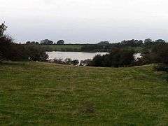 The tarn from which the settlement derives its name | |
 Tarns Tarns shown within Cumbria | |
| OS grid reference | NY117478 |
| Civil parish | |
| District | |
| Shire county | |
| Region | |
| Country | England |
| Sovereign state | United Kingdom |
| Post town | WIGTON |
| Postcode district | CA7 |
| Dialling code | 016973 |
| Police | Cumbria |
| Fire | Cumbria |
| Ambulance | North West |
| EU Parliament | North West England |
| UK Parliament | |
Tarns is a small farming settlement in the civil parish of Holme St. Cuthbert in Cumbria, United Kingdom. It is located two miles north-east of the village of Mawbray, and twenty-three miles south-west of Carlisle, Cumbria's county town. The B5301 road runs through the settlement, and along that road the town of Silloth-on-Solway is located five-and-a-half miles to the north, and Aspatria four-and-a-half miles to the south-east. Other nearby settlements include Aikshaw, Goodyhills, Jericho, and New Cowper.[1]
History and etymology
The name Tarns comes from the Old Norse "tiorn", meaning a lake, and "tarn" is a word commonly used in northern England for a lake or pond. Such a lake is present at Tarns, giving the settlement its name. In the past, the name has been spelled as Ternis, Terns, and Tarnes.[2]
Tarns is a small settlement, and, in spite of appearing on local signposts,[3] including on the B5300 coast road,[4] it is not named on some contemporary mapping projects like Google Maps. However, it does appear in the historical record, with records of births and deaths dating from at least the early 19th century.[5] It is also noted on historical documents from the time of Holme Cultram Abbey's operation prior to the dissolution of the monasteries, where a farm owned by the abbey was operating at Tarns in or around 1200 AD.[6]
The tarn for which the settlement is named has a surface area of 21 acres (8.5 hectares), and a perimeter of three-quarters of a mile (1.1 km).[7]
Local amenities
Tarns has no public transportation links, though a shuttle-bus is laid on to and from Aspatria railway station (the nearest station to the settlement) for visitors to Solfest during the August bank holiday weekend.[8] The nearest stops on a mainline bus service are two-and-a-half miles away at either Mawbray or Beckfoot on the B5300 road, where services run every two hours in the direction of Silloth and Maryport, or alternatively four miles away at Abbeytown, where buses run from Silloth to Carlisle via Wigton.
There is a public house, called The Lowther, at nearby Mawbray, and in the past there was another, the Swan Inn, at Westnewton. The nearest shops are in Aspatria, Abbeytown, and Silloth.
Solfest
Tarnside Farm, one of the farms at Tarns, hosts an annual music festival called Solfest on the August bank holiday weekend. Short for "SOLway music FESTival", Solfest started in 2004 and has attracted such artists as Badly Drawn Boy, Seth Lakeman, The Proclaimers, and Kate Rusby. Solfest was cancelled in 2014, after ten consecutive years, but organisers reassured festival-goers that the event would return in August 2015.[9]
The full price for an adult ticket for Solfest 2012 was £95, with young people aged 12–16 paying £65, and children paying £35.[10] In 2007, Solfest won the "Best Family Festival" award.[11]
References
| Wikimedia Commons has media related to Tarns, Cumbria. |
- ↑ "Google Maps - Tarns". Retrieved 11 January 2015.
- ↑ Holme St. Cuthbert History Group (2004). Plain People: Bygone Times on the Solway Plain.
- ↑ "Marra Man - Jericho Crossroads". Retrieved 11 January 2015.
- ↑ "Marra Man - Mawbray Crossroads". Retrieved 11 January 2015.
- ↑ "Webtrees genealogy - Joseph Holliday". Retrieved 11 January 2015.
- ↑ "Roots Web - Plain People". Retrieved 11 January 2015.
- ↑ "British Lakes - Tarns Dub, Cumbria". Retrieved 11 January 2015.
- ↑ "Solfest - Shuttle bus". Retrieved 11 January 2015.
- ↑ "ITV Border - Solfest 2014 cancelled". Retrieved 11 January 2015.
- ↑ "Solfest - Tickets (via the Wayback Machine)". Archived from the original on April 21, 2012. Retrieved 11 January 2015.
- ↑ "Festival Awards - 2007 winners". Retrieved 11 January 2015.