Aspatria railway station
| Aspatria | |
|---|---|
 | |
| Location | |
| Place | Aspatria |
| Local authority | Allerdale |
| Coordinates | 54°45′32″N 3°19′55″W / 54.759°N 3.332°WCoordinates: 54°45′32″N 3°19′55″W / 54.759°N 3.332°W |
| Grid reference | NY143412 |
| Operations | |
| Station code | ASP |
| Managed by | Northern |
| Number of platforms | 2 |
| DfT category | F2 |
|
Live arrivals/departures, station information and onward connections from National Rail Enquiries | |
| Annual rail passenger usage* | |
| 2012/13 |
|
| 2013/14 |
|
| 2014/15 |
|
| 2015/16 |
|
| 2016/17 |
|
| History | |
| Key dates | Opened 12 April 1841 |
| National Rail – UK railway stations | |
| * Annual estimated passenger usage based on sales of tickets in stated financial year(s) which end or originate at Aspatria from Office of Rail and Road statistics. Methodology may vary year on year. | |
|
| |
| Maryport and Carlisle Railway | ||||||||||||||||||||||||||||||||||||||||||||||||||||||||||||||||||||||||||||||||||||||||||||||||||||||||||||||||||||||||||||||||||||||||||||||||||||||||||||||||||||||||||||||||||||||||||||||||||||||||||||||||||||||||
|---|---|---|---|---|---|---|---|---|---|---|---|---|---|---|---|---|---|---|---|---|---|---|---|---|---|---|---|---|---|---|---|---|---|---|---|---|---|---|---|---|---|---|---|---|---|---|---|---|---|---|---|---|---|---|---|---|---|---|---|---|---|---|---|---|---|---|---|---|---|---|---|---|---|---|---|---|---|---|---|---|---|---|---|---|---|---|---|---|---|---|---|---|---|---|---|---|---|---|---|---|---|---|---|---|---|---|---|---|---|---|---|---|---|---|---|---|---|---|---|---|---|---|---|---|---|---|---|---|---|---|---|---|---|---|---|---|---|---|---|---|---|---|---|---|---|---|---|---|---|---|---|---|---|---|---|---|---|---|---|---|---|---|---|---|---|---|---|---|---|---|---|---|---|---|---|---|---|---|---|---|---|---|---|---|---|---|---|---|---|---|---|---|---|---|---|---|---|---|---|---|---|---|---|---|---|---|---|---|---|---|---|---|---|---|---|---|
| ||||||||||||||||||||||||||||||||||||||||||||||||||||||||||||||||||||||||||||||||||||||||||||||||||||||||||||||||||||||||||||||||||||||||||||||||||||||||||||||||||||||||||||||||||||||||||||||||||||||||||||||||||||||||
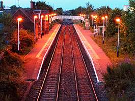
Aspatria railway station serves the town of Aspatria in Cumbria, England. The railway station is a request stop on part of the scenic Cumbrian Coast Line 20 miles (32 km) south west of Carlisle. The station is operated by Northern who provide all passenger train services.
History
Opened by the Maryport and Carlisle Railway in 1841 (although the line through to Carlisle wasn't completed until 1845), the station was once the junction for the branch line to Mealsgate. Passenger trains on this route began in 1866 but ceased in September 1930 and complete closure followed in 1952.[1]
The station became part of the London, Midland and Scottish Railway during the Grouping of 1923, and then passed on to the London Midland Region of British Railways on nationalisation in 1948.
When Sectorisation was introduced in the 1980s, the station was served by Regional Railways until the Privatisation of British Railways.
The station signal box was the last surviving example built by the Maryport & Carlisle company prior to its closure and demolition in 1998.[2]
Facilities
The station is unstaffed and has no ticket machine, so tickets must be purchased prior to travel or on the train (the main buildings are now in private residential use). Shelters are located on both platforms. Timetable posters and a telephone are provided to give train running information, whilst there is also public wifi access on offer. The platforms are linked by footbridge and there is step-free access to each one.[3]
Service
There is generally an hourly service northbound to Carlisle and southbound to Whitehaven with most trains going onward to Barrow-in-Furness (no late evening service operates south of Whitehaven).[4]
Train operator Northern introduced a regular through sunday service to Barrow via the coast at the May 2018 timetable change - the first such service south of Whitehaven for more than 40 years. Services run approximately hourly from late morning until early evening, with later trains terminating at Whitehaven. This represents a major upgrade on the former infrequent service of four per day each way to/from Whitehaven only that previously operated.
See also
Notes
- ↑ The Bolton Loop
- ↑ Aspatria Signal Box
- ↑ Aspatria station facilities National Rail Enquiries; Retrieved 20 December 2016
- ↑ GB eNRT May 2018 Edition, Table 100
References
- Marshall, J (1981) Forgotten Railways North-West England, David & Charles (Publishers) Ltd, Newton Abbott. ISBN 0-7153-8003-6
- Butt, R. V. J. (1995). The Directory of Railway Stations: details every public and private passenger station, halt, platform and stopping place, past and present (1st ed.). Sparkford: Patrick Stephens Ltd. ISBN 978-1-85260-508-7. OCLC 60251199.
- Jowett, Alan (2000). Jowett's Nationalised Railway Atlas (1st ed.). Penryn, Cornwall: Atlantic Transport Publishers. ISBN 978-0-906899-99-1. OCLC 228266687.
- Jowett, Alan (March 1989). Jowett's Railway Atlas of Great Britain and Ireland: From Pre-Grouping to the Present Day (1st ed.). Sparkford: Patrick Stephens Ltd. ISBN 978-1-85260-086-0. OCLC 22311137.
- Station on navigable O.S. map
External links
| Wikimedia Commons has media related to Aspatria railway station. |
- Train times and station information for Aspatria railway station from National Rail
- The station, via Holme St Cuthbert History Group
| Preceding station | Following station | |||
|---|---|---|---|---|
| Northern Cumbrian Coast Line | ||||
| Historical railways | ||||
Line open, station closed | Maryport and Carlisle Railway | Line open, station closed |
||
| Disused railways | ||||
Line and station closed | Maryport and Carlisle Railway Bolton Loop | Line open, station closed |
||