Tairua
| Tairua | |
|---|---|
 | |
 Tairua | |
| Coordinates: 37°00′23″S 175°50′56″E / 37.00639°S 175.84889°ECoordinates: 37°00′23″S 175°50′56″E / 37.00639°S 175.84889°E | |
| Country | New Zealand |
| Region | Waikato |
| District | Thames-Coromandel District |
| Population (June 2018)[1] | |
| • Total | 1,430 |
| Postcode(s) | 3508 |
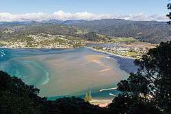
The town of Tairua is on the east coast of the Coromandel Peninsula in the North Island of New Zealand. It lies at the mouth of the Tairua River on its north bank and on the small Paku Peninsula.[2] The population was 1,227 in the 2013 Census, a decrease of 42 from 2006.[3] Tairua is a Māori name which translates literally as tai: tides, rua: two.[4]
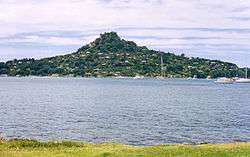
Directly opposite Tairua on the south bank of the river's estuary is the smaller settlement of Pauanui. The two settlements are 30 kilometres east of Thames although the town has closer connections with the sea side resort town Whangamata. Several islands lie off the mouth of the river, notably Slipper Island to the southeast and the Alderman Islands 20 kilometres to the east. Mount Paku is an extinct volcano that lies by Tairua Harbour. It was thought to have formed the Alderman Islands.
History and features
The earliest occupation of the area was once thought to have been by early Polynesian explorers based on the discovery of a pearl-shell (not native to New Zealand) lure shank found here[5] and originally carbon-dated to the 11th century.[4] Subsequent reassessment of the archaeological site has resulted in dates in the 14th century[6]
Early European settlers to the area, in the late 19th century, were primarily drawn by timber stocks (predominantly kauri) and gold prospecting.[7]
From the late 1960s Tairua has become a holiday destination,[7] with major activities including game fishing, scuba diving, and surfing.
Radio Tairua is an independent radio station on frequency 88.3FM, which has broadcast to the area since May 2007.[8]
Climate
Tairua features an extremely mild oceanic climate (Köppen: Cfb) with no month having an average temperature above 20°C or below 10°C. As a result of this, temperatures above 30°C or below 0°C are almost unheard of with the town being a popular holiday location because of its mild weather, beautiful beaches and rugged hills and mountains. These surrounding hills and mountains also cause the city to see significant rainfall throughout the year, especially in winter which can often lead to flooding and slips which isolate the community (almost annually) for a day or two at a time. This high rainfall also leads to lush temperate rainforest vegetation surrounding the city.
| Climate data for Tairua, New Zealand (1981–2010) | |||||||||||||
|---|---|---|---|---|---|---|---|---|---|---|---|---|---|
| Month | Jan | Feb | Mar | Apr | May | Jun | Jul | Aug | Sep | Oct | Nov | Dec | Year |
| Average high °C (°F) | 24.2 (75.6) |
24.3 (75.7) |
22.9 (73.2) |
20.5 (68.9) |
17.6 (63.7) |
15.4 (59.7) |
14.7 (58.5) |
15.3 (59.5) |
16.7 (62.1) |
18.4 (65.1) |
20.5 (68.9) |
22.3 (72.1) |
19.4 (66.9) |
| Daily mean °C (°F) | 19.4 (66.9) |
19.6 (67.3) |
18.4 (65.1) |
16 (61) |
13.1 (55.6) |
11.1 (52) |
10.3 (50.5) |
11 (52) |
12.5 (54.5) |
14.1 (57.4) |
16.1 (61) |
17.8 (64) |
14.9 (58.9) |
| Average low °C (°F) | 14.7 (58.5) |
15 (59) |
13.9 (57) |
11.5 (52.7) |
8.7 (47.7) |
6.9 (44.4) |
5.9 (42.6) |
6.8 (44.2) |
8.3 (46.9) |
9.9 (49.8) |
11.7 (53.1) |
13.3 (55.9) |
10.6 (51) |
| Average precipitation mm (inches) | 131 (5.16) |
122 (4.8) |
189 (7.44) |
152 (5.98) |
164 (6.46) |
211 (8.31) |
184 (7.24) |
199 (7.83) |
158 (6.22) |
121 (4.76) |
125 (4.92) |
129 (5.08) |
1,885 (74.2) |
| Source: NIWA[9] | |||||||||||||
Education
Tairua School is a coeducational full primary (years 1-8) school with a decile rating of 7 and a roll of 102.[10]
Notes
- ↑ "Subnational Population Estimates: At 30 June 2018 (provisional)". Statistics New Zealand. 23 October 2018. Retrieved 23 October 2018. For urban areas, "Subnational population estimates (UA, AU), by age and sex, at 30 June 1996, 2001, 2006-18 (2018 boundary)". Statistics New Zealand. 23 October 2018. Retrieved 23 October 2018.
- ↑ Peter Dowling (editor) (2004). Reed New Zealand Atlas. Reed Books. pp. map 17. ISBN 0-7900-0952-8.
- ↑ 2013 Census QuickStats about a place: Tairua
- 1 2 Wises New Zealand Guide, 7th Edition, 1979. p. 412.
- ↑ University of Auckland Library: Anthropology Photographic Archive
- ↑ Archaeological Monitoring at T11/62, The Tairua Site (Report to Heritage New Zealand)
- 1 2 "Tairua History". Archived from the original on 2010-06-02. Retrieved 2010-06-01.
- ↑ "Radio Tairua". Archived from the original on 2010-05-26. Retrieved 2010-06-01.
- ↑ "Climate Data and Activities". NIWA Science. Retrieved 15 October 2013.
- ↑ "Te Kete Ipurangi - Tairua School". Ministry of Education.
External links
| Wikivoyage has a travel guide for Tairua. |