Aldermen Islands
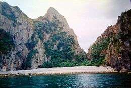 A bay on one of the Aldermen Islands. | |
| Geography | |
|---|---|
| Location | Mercury Bay in the North Island |
| Coordinates | 36°58′S 176°05′E / 36.967°S 176.083°E |
| Area | 1 km2 (0.39 sq mi) |
| Administration | |
| Demographics | |
| Population | 0 |
The Aldermen Islands are a small group of rocky islets to the southeast of Mercury Bay in the North Island of New Zealand. They are located off the coast of the Coromandel Peninsula, 20 kilometres (12 mi) east of the mouth of the Tairua River.
The islands were named 'the Court of Aldermen' by Captain Cook and his crew on 3 November 1769 after previously naming Mayor Island.[1] The Aldermen group consists of four main islands: Hongiora, Middle, Ruamahuanui, and Ruamahuaiti, which are the remnants of a volcanic cone. Their combined area is just under 1 km2 (0.4 sq mi). The islands are a forested nature reserve hosting rare species including the tuatara. Access is by permit only. Coordinates: 36°58′S 176°05′E / 36.967°S 176.083°E
See also
References
- ↑ Cook, J., Wharton, Sir W. J. L. (1968) Captain Cook's journal during his first voyage round the world, made in H. M. Bark 'Endeavour', 1768-71 : a literal transcription of the original mss ; with notes and introd. ed. by Captain W. J. L. Warton. Adelaide: Libraries Board of South Australia.
External links
This article is issued from
Wikipedia.
The text is licensed under Creative Commons - Attribution - Sharealike.
Additional terms may apply for the media files.