TIROS-1
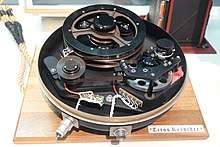
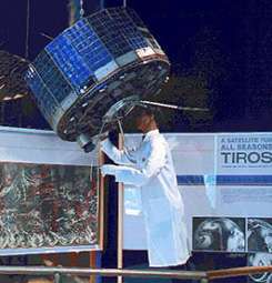 Tiros I prototype on display at the Smithsonian National Air and Space Museum. | |
| Mission type | Weather satellite |
|---|---|
| Operator | NASA[1] |
| Harvard designation | 1960 β 2 |
| COSPAR ID | 1960-002B |
| SATCAT no. | 29 |
| Mission duration | 78 days |
| Spacecraft properties | |
| Spacecraft type | TIROS |
| Manufacturer | RCA Astro |
| Launch mass | 122.5 kilograms (270 lb)[2] |
| Start of mission | |
| Launch date | April 1, 1960, 11:40:09 UTC[3] |
| Rocket | Thor DM-18 Able II |
| Launch site | Cape Canaveral LC-17A |
| End of mission | |
| Last contact | June 15, 1960 |
| Orbital parameters | |
| Reference system | Geocentric |
| Regime | LEO |
| Semi-major axis | 7,026.96 kilometers (4,366.35 mi)[4] |
| Eccentricity | 0.0024623 |
| Perigee | 631 kilometers (392 mi) |
| Apogee | 665 kilometers (413 mi) |
| Inclination | 48.3797° |
| Period | 98.76 minutes |
| RAAN | 264.3671 degrees |
| Argument of perigee | 226.1327 degrees |
| Mean anomaly | 133.7550 degrees |
| Mean motion | 14.74045109 |
| Epoch | April 22, 2016, 21:05:55 UTC |
| Instruments | |
|
two slow-scan visible television camera (wide-angle and narrow-angle) horizon sensor sun angle sensor | |
TIROS I (or TIROS-1) was the first successful low-Earth orbital weather satellite, and the first of a series of Television Infrared Observation Satellites.
Launch
The TIROS-1 spacecraft was launched by NASA and partners at 6:40 AM EST[5] on April 1, 1960, from Cape Canaveral, Florida, in the United States. Mission partners were NASA, the U.S. Army Signal Research and Development Laboratory, RCA, the U.S. Weather Bureau, and the U.S. Naval Photographic Interpretation Center.[1]
Program
The TIROS Program was NASA's first experimental step to determine if satellites could be useful in the study of the Earth. At that time, the effectiveness of satellite observations was still unproven. Since satellites were a new technology, the TIROS Program also tested various design issues for spacecraft: instruments, data and operational parameters. The goal was to improve satellite applications for Earth-bound decisions, such as "should we evacuate the coast because of the hurricane?".[1]
The TIROS Program's first priority was the development of a meteorological satellite information system. Weather forecasting was deemed the most promising application of space-based observations.[1]
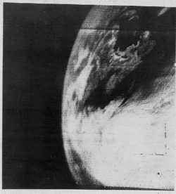
TIROS proved extremely successful, providing the first accurate weather forecasts based on data gathered from space. TIROS began continuous coverage of the Earth's weather in 1962, and was used by meteorologists worldwide. The program's success with many instrument types and orbital configurations led to the development of more sophisticated meteorological observation satellites.[1]
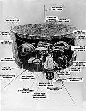
Instruments
The two cameras for TIROS-1 were for the visible spectrum. The cameras were slow-scan, taking a half-second to record an image, but had a 1.5 millisecond shutter. One camera had a wide-angle lens (104 degrees/~750 miles) with the other having a narrow-angle (12.67 degrees/~65 miles) with corresponding image resolutions of 1.5 miles and 1000 feet. Also included were a horizon sensor and a sun sensor, both used for indicating the orientation of the satellite for the images.
References
- 1 2 3 4 5 "TIROS". NASA Science. Retrieved December 8, 2013.
- ↑ "TIROS 1". National Space Science Data Center. Retrieved December 8, 2013.
- ↑ McDowell, Jonathan. "Launch Log". Jonathan's Space Page. Retrieved December 8, 2013.
- ↑ "TIROS 1 Satellite details 1960-002B NORAD 29". N2YO. December 7, 2013. Retrieved December 8, 2013.
- ↑ "U.S. Launches Camera Weather Satellite". The Fresno Bee. AP and UPI. April 1, 1960. pp. 1a, 4a.
- ↑ Anderson, George D. (April 1, 2010). "The first weather satellite picture". Weather. 65 (4): 87–87. Bibcode:2010Wthr...65...87A. doi:10.1002/wea.550. ISSN 1477-8696.
External links
- TIROS – NASA Science
- Final Report on the TIROS I Meteorological Satellite System
- The Smithsonian National Air & Space Museum Exhibition List
- TIROS 1 & 2 Ground Control Canter at Camp Evans - preserved by InfoAge Science History Center
- Published story of how the first TIROS photo was flown by helicopter, then a jet from the Camp Evans Ground Control Center to NASA
- TIROS I is Launched - NOAASIS
- TIROS-1 50th Anniversary & Resources on Satellite Meteorology
- NASA's YouTube video of TIROS-1