Túpac Amaru District
| Tupac Amaru Tupaq Amaru | |
|---|---|
| District | |
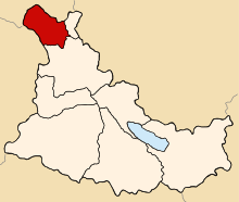 Location of Tupac Amaru in the Canas province | |
| Country |
|
| Region | Cusco |
| Province | Canas |
| Founded | September 1, 1941 |
| Capital | Tungasuca |
| Government | |
| • Mayor | Honorato Ttito Quispe (2007) |
| Area | |
| • Total | 117.81 km2 (45.49 sq mi) |
| Elevation | 3,791 m (12,438 ft) |
| Population (2005 census) | |
| • Total | 3,423 |
| • Density | 29/km2 (75/sq mi) |
| Time zone | UTC-5 (PET) |
| UBIGEO | 080508 |
Tupac Amaru District is one of eight districts in the Canas Province in Peru. Its seat is the village of Tungasuca.
Geography
One of the highest peaks of the district is Puka Kancha at approximately 4,400 m (14,400 ft). Other mountains are listed below:[1]
- Anka Suka
- Ayna
- Hatun Ñan
- Pukara
- Suka
- Tunka Suka
- Wanu Kunka
Ethnic groups
The people in the district are mainly indigenous citizens of Quechua descent. Quechua is the language which the majority of the population (97.85%) learnt to speak in childhood, 1.72% of the residents started speaking using the Spanish language (2007 Peru Census).[2]
Sources
- ↑ escale.minedu.gob.pe/ UGEL map Canas Province (Cusco Region)
- ↑ inei.gob.pe Archived 2013-01-27 at the Wayback Machine. INEI, Peru, Censos Nacionales 2007, Frequencias: Preguntas de Población
| |
|---|---|
| Acomayo | |
| Anta | |
| Calca | |
| Canas | |
| Canchis | |
| Chumbivilcas | |
| Cusco | |
| Espinar | |
| La Convención | |
| Paruro | |
| Paucartambo | |
| Quispicanchi | |
| Urubamba | |
This article is issued from
Wikipedia.
The text is licensed under Creative Commons - Attribution - Sharealike.
Additional terms may apply for the media files.