Checca District
| Checca Ch'iqa | |
|---|---|
| District | |
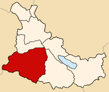 Location of Checca in the Canas province | |
| Country |
|
| Region | Cusco |
| Province | Canas |
| Founded | January 2, 1857 |
| Capital | Checca |
| Government | |
| • Mayor | Pablo Cesar Chaiña Carpio (2007) |
| Area | |
| • Total | 503.76 km2 (194.50 sq mi) |
| Elevation | 3,810 m (12,500 ft) |
| Population (2005 census) | |
| • Total | 6,490 |
| • Density | 13/km2 (33/sq mi) |
| Time zone | UTC-5 (PET) |
| UBIGEO | 080502 |
| Website | munichecca.gob.pe |
Checca District is the largest of eight districts in the Canas Province in Peru. Its seat is Checca.
Geography
One of the highest peaks of the district is Anta Qalla at approximately 4,600 m (15,100 ft). Other mountains are listed below:[1]
- Ararankha
- Iruni
- Kiska Muqu
- Marka Marka
- Saywa
- Suntur Uta
- Sura Tira
- Tuqtu
- Urqu K'uchu
- Wanqarani
- Yuraq Q'asa
Ethnic groups
The people in the district are mainly indigenous citizens of Quechua descent. Quechua is the language which the majority of the population (98.68%) learnt to speak in childhood, 1.10% of the residents started speaking using the Spanish language (2007 Peru Census).[2]
References
- ↑ escale.minedu.gob.pe/ UGEL map Canchis Province (Cusco Region)
- ↑ inei.gob.pe Archived January 27, 2013, at the Wayback Machine. INEI, Peru, Censos Nacionales 2007, Frequencias: Preguntas de Población
External links
- (in Spanish) Municipal website
| |
|---|---|
| Acomayo | |
| Anta | |
| Calca | |
| Canas | |
| Canchis | |
| Chumbivilcas | |
| Cusco | |
| Espinar | |
| La Convención | |
| Paruro | |
| Paucartambo | |
| Quispicanchi | |
| Urubamba | |
This article is issued from
Wikipedia.
The text is licensed under Creative Commons - Attribution - Sharealike.
Additional terms may apply for the media files.