Lamay District
| Lamay | |
|---|---|
| District | |
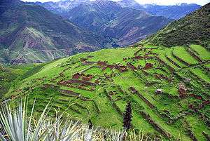 The Willkapampa valley of the Lamay District as seen from the archaeological site of Huch'uy Qusqu | |
| Country |
|
| Region | Cusco |
| Province | Calca |
| Founded | January 3, 1952 |
| Capital | Lamay |
| Government | |
| • Mayor | Guido Alvarez Chavez |
| Area | |
| • Total | 94.22 km2 (36.38 sq mi) |
| Elevation | 2,941 m (9,649 ft) |
| Population (2005 census) | |
| • Total | 5,633 |
| • Density | 60/km2 (150/sq mi) |
| Time zone | UTC-5 (PET) |
| UBIGEO | 080403 |
Lamay District is one of eight districts of the province Calca in Peru.[1]
Geography
Some of the highest mountains of the district are listed below:[2]
|
|
Ethnic groups
The people in the district are mainly indigenous citizens of Quechua descent. Quechua is the language which the majority of the population (81.43%) learnt to speak in childhood, 18.05% of the residents started speaking using the Spanish language (2007 Peru Census).[3]
See also
References
- ↑ (in Spanish) Instituto Nacional de Estadística e Informática. Banco de Información Distrital Archived 2008-04-23 at the Wayback Machine.. Retrieved April 11, 2008.
- ↑ escale.minedu.gob.pe - UGEL map of the Calca Province (Cusco Region)
- ↑ inei.gob.pe Archived 2013-01-27 at the Wayback Machine. INEI, Peru, Censos Nacionales 2007, Frequencias: Preguntas de Población
| |
|---|---|
| Acomayo | |
| Anta | |
| Calca | |
| Canas | |
| Canchis | |
| Chumbivilcas | |
| Cusco | |
| Espinar | |
| La Convención | |
| Paruro | |
| Paucartambo | |
| Quispicanchi | |
| Urubamba | |
This article is issued from
Wikipedia.
The text is licensed under Creative Commons - Attribution - Sharealike.
Additional terms may apply for the media files.