Sutton Waldron
| Sutton Waldron | |
|---|---|
 Sutton Waldron | |
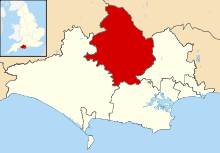
 Sutton Waldron Sutton Waldron shown within Dorset | |
| Population | 200 |
| OS grid reference | ST862158 |
| Civil parish |
|
| District | |
| Shire county | |
| Region | |
| Country | England |
| Sovereign state | United Kingdom |
| Post town | BLANDFORD FORUM |
| Postcode district | DT11 |
| Dialling code | 01747 |
| Police | Dorset |
| Fire | Dorset and Wiltshire |
| Ambulance | South Western |
| EU Parliament | South West England |
| UK Parliament | |
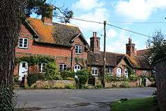
Sutton Waldron is a village and civil parish in north Dorset, England, situated on the A350 road between Iwerne Minster and Fontmell Magna, in the Blackmore Vale under the scarp of Cranborne Chase, 8 miles (13 km) north of Blandford Forum and 5 miles (8.0 km) south of Shaftesbury. In the 2011 census the parish had 93 dwellings,[1] 87 households and a population of 200.[2]
The parish covers about 1,300 acres (530 ha) in a strip of land that, from west to east, is composed of Kimmeridge clay, Lower Greensand, Gault Clay, Upper Greensand and chalk.[3]
In 1086 in the Domesday Book Sutton Waldron was recorded as Sudtone;[4] it had 24 households, one mill, six ploughlands, 6 acres (2.4 ha) of meadow and 40 acres (16 ha) of woodland. It was in the hundred of Gillingham and the lord and tenant-in-chief was Waleran the hunter.[5]
The parish church dates from 1847 and is constructed in the Decorated Gothic style.[6]
References
- ↑ "Area: Sutton Waldron (Parish). Dwellings, Household Spaces and Accommodation Type, 2011 (KS401EW)". Neighbourhood Statistics. Office for National Statistics. Retrieved 5 June 2015.
- ↑ "Area: Sutton Waldron (Parish). Key Figures for 2011 Census: Key Statistics". Neighbourhood Statistics. Office for National Statistics. Retrieved 5 June 2015.
- ↑ "'Sutton Waldron', in An Inventory of the Historical Monuments in Dorset, Volume 4, North (London, 1972), pp. 84-88". British History Online. University of London. Retrieved 20 February 2015.
- ↑ "Dorset S-Z". The Domesday Book Online. domesdaybook.co.uk. Retrieved 20 February 2015.
- ↑ "Place: Sutton [Waldron]". Open Domesday. domesdaymap.co.uk. Retrieved 20 February 2015.
- ↑ North Dorset District Council (1982–83). North Dorset District Official Guide. Home Publishing Co. Ltd. p. 49.
External links
![]()