Sutton, Vermont
| Sutton, Vermont | |
|---|---|
| Town | |
 Sutton, Vermont | |
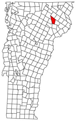
 Sutton, Vermont Location in the United States | |
| Coordinates: 44°39′15″N 72°1′45″W / 44.65417°N 72.02917°WCoordinates: 44°39′15″N 72°1′45″W / 44.65417°N 72.02917°W | |
| Country | United States |
| State | Vermont |
| County | Caledonia |
| Communities |
Sutton East Sutton Ridge Perry Summit Sutton Station |
| Area | |
| • Total | 38.4 sq mi (99.4 km2) |
| • Land | 38.2 sq mi (98.9 km2) |
| • Water | 0.2 sq mi (0.5 km2) |
| Elevation | 1,398 ft (426 m) |
| Population (2010) | |
| • Total | 1,029 |
| • Density | 27/sq mi (10.4/km2) |
| Time zone | UTC-5 (Eastern (EST)) |
| • Summer (DST) | UTC-4 (EDT) |
| ZIP code | 05867 |
| Area code(s) | 802 |
| FIPS code | 50-71575[1] |
| GNIS feature ID | 1462224[2] |
Sutton is a town in Caledonia County, Vermont, United States. The population was 1,029 at the 2010 census.[3]
Geography
Sutton is located in northern Caledonia County. It is bordered by the town of Lyndon to the south, Wheelock to the southwest, Sheffield to the west, Barton to the northwest, Westmore to the north, Newark to the northeast, and Burke to the east. According to the United States Census Bureau, the town has a total area of 38.4 square miles (99.4 km2), of which 38.2 square miles (98.9 km2) is land and 0.19 square miles (0.5 km2), or 0.51%, is water.[3]
The highest point in Sutton is the summit of Mount Hor in the northern corner of town, with an elevation of 2,656 feet (809.5 m) above sea level.[4]
Demographics
| Historical population | |||
|---|---|---|---|
| Census | Pop. | %± | |
| 1800 | 144 | — | |
| 1810 | 433 | 200.7% | |
| 1820 | 697 | 61.0% | |
| 1830 | 1,005 | 44.2% | |
| 1840 | 1,068 | 6.3% | |
| 1850 | 1,001 | −6.3% | |
| 1860 | 987 | −1.4% | |
| 1870 | 920 | −6.8% | |
| 1880 | 838 | −8.9% | |
| 1890 | 746 | −11.0% | |
| 1900 | 694 | −7.0% | |
| 1910 | 711 | 2.4% | |
| 1920 | 659 | −7.3% | |
| 1930 | 596 | −9.6% | |
| 1940 | 561 | −5.9% | |
| 1950 | 528 | −5.9% | |
| 1960 | 476 | −9.8% | |
| 1970 | 438 | −8.0% | |
| 1980 | 667 | 52.3% | |
| 1990 | 854 | 28.0% | |
| 2000 | 1,001 | 17.2% | |
| 2010 | 1,029 | 2.8% | |
| Est. 2014 | 1,019 | [5] | −1.0% |
| U.S. Decennial Census[6] | |||
As of the census[1] of 2000, there were 1,001 people, 366 households, and 270 families residing in the town. The population density was 26.2 people per square mile (10.1/km2). There were 439 housing units at an average density of 11.5 per square mile (4.4/km2). The racial makeup of the town was 97.60% White, 0.20% Native American, 0.20% Asian, 1.20% from other races, and 0.80% from two or more races. Hispanic or Latino of any race were 0.40% of the population.
There were 366 households out of which 38.3% had children under the age of 18 living with them, 61.5% were married couples living together, 6.3% had a female householder with no husband present, and 26.2% were non-families. 18.6% of all households were made up of individuals and 7.7% had someone living alone who was 65 years of age or older. The average household size was 2.73 and the average family size was 3.10.
In the town, the population was spread out with 29.8% under the age of 18, 5.8% from 18 to 24, 27.9% from 25 to 44, 25.0% from 45 to 64, and 11.6% who were 65 years of age or older. The median age was 37 years. For every 100 females, there were 102.2 males. For every 100 females age 18 and over, there were 102.0 males.
The median income for a household in the town was $36,750, and the median income for a family was $40,368. Males had a median income of $27,303 versus $25,000 for females. The per capita income for the town was $14,564. About 10.5% of families and 13.0% of the population were below the poverty line, including 22.2% of those under age 18 and 17.9% of those age 65 or over.
Notable people
- Luis Guzmán, actor[7]
- Edward Hoagland, essayist[8]
- Henry Oscar Houghton, co-founder of Houghton Mifflin
- Garret Keizer, author and essayist
Climate
This climatic region is typified by large seasonal temperature differences, with warm to hot summers and cold winters. [9]
| Climate data for Sutton 2 NE | |||||||||||||
|---|---|---|---|---|---|---|---|---|---|---|---|---|---|
| Month | Jan | Feb | Mar | Apr | May | Jun | Jul | Aug | Sep | Oct | Nov | Dec | Year |
| Record high °F (°C) | 61 (16) |
61 (16) |
77 (25) |
90 (32) |
92 (33) |
95 (35) |
98 (37) |
96 (36) |
96 (36) |
83 (28) |
70 (21) |
60 (16) |
98 (37) |
| Average high °F (°C) | 24 (−4) |
27 (−3) |
37 (3) |
51 (11) |
65 (18) |
74 (23) |
79 (26) |
77 (25) |
68 (20) |
55 (13) |
41 (5) |
29 (−2) |
52 (11) |
| Average low °F (°C) | −1 (−18) |
−1 (−18) |
11 (−12) |
26 (−3) |
36 (2) |
46 (8) |
51 (11) |
48 (9) |
41 (5) |
31 (−1) |
22 (−6) |
8 (−13) |
26 (−3) |
| Record low °F (°C) | −40 (−40) |
−41 (−41) |
−34 (−37) |
−11 (−24) |
15 (−9) |
19 (−7) |
29 (−2) |
26 (−3) |
19 (−7) |
9 (−13) |
−12 (−24) |
−35 (−37) |
−41 (−41) |
| Source: https://wrcc.dri.edu/cgi-bin/cliMAIN.pl?vt8172 | |||||||||||||
References
- 1 2 "American FactFinder". United States Census Bureau. Archived from the original on September 11, 2013. Retrieved August 12, 2016.
- ↑ "US Board on Geographic Names". United States Geological Survey. October 25, 2007. Retrieved August 12, 2016.
- 1 2 "Geographic Identifiers: 2010 Demographic Profile Data (G001): Sutton town, Caledonia County, Vermont". U.S. Census Bureau, American Factfinder. Retrieved February 6, 2013.
- ↑ U.S. Geological Survey Sutton, VT 7.5-minute quadrangle, 1986.
- ↑ "Annual Estimates of the Resident Population for Incorporated Places: April 1, 2010 to July 1, 2014". Archived from the original on May 23, 2015. Retrieved June 4, 2015.
- ↑ "U.S. Decennial Census". United States Census Bureau. Archived from the original on May 12, 2015. Retrieved May 16, 2015.
- ↑ "Joint Concurrent House Resolution". State of Vermont. Retrieved August 12, 2016.
- ↑ "Edward Hoagland | American writer". Encyclopedia Britannica. Retrieved 2017-09-14.
- ↑ https://wrcc.dri.edu/cgi-bin/cliMAIN.pl?vt8172
Municipalities and communities of Caledonia County, Vermont, United States | ||
|---|---|---|
| Towns | 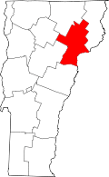 | |
| Incorporated villages | ||
| Non-village CDPs | ||
| Unincorporated communities | ||